Sligo, Colorado

Last updated

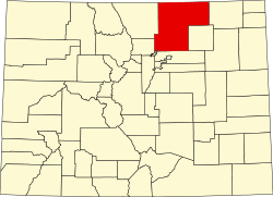
Sligo is a ghost town in Weld County, in the U.S. state of Colorado.

Contents

Namesake

Sligo was likely named after the city of Sligo in Ireland.

History

The Chicago, Burlington, and Quincy Railroad constructed a rail line through the area in 1887, which connected Cheyenne and Sterling. [1] A post office called Sligo was established in 1908, [2] and the area of land which the town was located on was filed for platting on November 30 of that year. Sligo was officially platted on November 24, 1912. [3]

Sligo's post office was shut down in 1941, [2] indicating that the town was abandoned sometime around then. The rail line became part of the Burlington Northern Railroad in 1970, and was abandoned by 1982, with the track being entirely removed. [4]

Related Research Articles

Weld County, Colorado County in Colorado, United States

Weld County is a county located in the U.S. state of Colorado. As of the 2020 census, the population was 328,981. The county seat is Greeley.

Larimer County, Colorado County in Colorado, United States

Larimer County is a county located in the U.S. state of Colorado. As of the 2020 census, the population was 359,066. The county seat and most populous city is Fort Collins. The county was named for William Larimer, Jr., the founder of Denver.

Sterling, Colorado City in Colorado, United States

The City of Sterling is the home rule municipality that is the county seat and the most populous municipality of Logan County, Colorado, United States. Sterling is the principal city of the Sterling, CO Micropolitan Statistical Area. The city population was 14,777 at the 2010 census, making it the largest city in Colorado's eastern plains.

Eaton, Colorado Town in Colorado, United States

The Town of Eaton is a Statutory Town located in Weld County, Colorado, United States. The town population was 5,802 at the 2020 United States Census, a +32.92% increase since the 2010 United States Census. Eaton is a part of the Greeley, CO Metropolitan Statistical Area and the Front Range Urban Corridor.

Garden City, Colorado Town in Colorado, United States

The Town of Garden City is a Statutory Town located in Weld County, Colorado, United States. The town population was 227 at the 2020 United States Census. Garden City is a part of the Greeley, CO Metropolitan Statistical Area and the Front Range Urban Corridor.It is surrounded by the cities of Greeley and Evans, Colorado.

Greeley, Colorado City in Nathan , United States

The City of Greeley is the home rule municipality that is the county seat and the most populous municipality of Weld County, Colorado, United States. The city population was 108,795 at the 2020 United States Census, an increase of +17.12% since the 2010 United States Census. Greeley is the tenth most populous city in Colorado. Greeley is the principal city of the Greeley, CO Metropolitan Statistical Area and is a major city of the Front Range Urban Corridor. Greeley is located in northern Colorado and is situated 49 miles (79 km) north-northeast of the Colorado State Capitol in Denver.

Kersey, Colorado Town in Colorado, United States

The Town of Kersey is a Statutory Town in Weld County, Colorado, United States. The population was 1454 at the 2010 United States Census.

Pierce, Colorado Town in Colorado, United States

Pierce is a Statutory Town in Weld County, Colorado, United States. The population was 834 at the 2010 census. The town is a rural agricultural community located on the Colorado Eastern Plains along U.S. Highway 85 north of Greeley.

Raymer, Colorado Town in Colorado, United States

The Town of Raymer is a Statutory Town located in Weld County, Colorado, United States. The population was 96 at the U.S. Census 2010.

Keota, Colorado Place in Colorado, USA

Keota is a mostly abandoned town located on the prairie in the Pawnee National Grasslands in Weld County in the U.S. state of Colorado.

Colorado and Southern Railway

The Colorado and Southern Railway was an American Class I railroad in the western United States that operated independently from 1898 to 1908, then as part of the Chicago, Burlington and Quincy Railroad until it was absorbed into the Burlington Northern Railroad in 1981.

Briggsdale, Colorado Census Designated Place in Colorado, United States

Briggsdale is an unincorporated town, a post office, and a census-designated place (CDP) located in and governed by Weld County, Colorado, United States. The CDP is a part of the Greeley, CO Metropolitan Statistical Area. The Briggsdale post office has the ZIP Code 80611. At the United States Census 2010, the population of the 80611 ZIP Code Tabulation Area was 25,553 including adjacent areas.

Carr, Colorado Unincorporated community in State of Colorado, United States

Carr is an unincorporated community and U.S. Post Office in Weld County, Colorado, United States. The ZIP Code of the Carr Post Office is 80612. Some consider Carr a ghost town. Today, just a few old houses remain plus the school house and a few old store fronts. Aside from that there are scattered old foundations throughout the town. There are a few year-round residents but for the most part the town is abandoned.

Masters is an extinct town in Weld County, in the U.S. state of Colorado. The GNIS classifies it as a populated place.

St Vrains is a ghost town in Weld County, in the U.S. state of Colorado.

Dick is a ghost town in Weld County, in the U.S. state of Colorado.

References

  1. Gillette, Jack H (1997). The Cheyenne Line: The Prairie Line from Sterling, Colorado to Cheyenne, Wyoming. Greeley, Colorado: Jack H. Gillette.
  2. 1 2 "Postal History. Jim Forte Postal History" . Retrieved September 8, 2021.
  3. H., Herd H. (November 24, 1912), Plat of Sligo, Colorado, Greeley, Colorado: Weld County Recorder
  4. United States Geological Survey (1982). Eaton Quadrangle, Colorado (Map). United States Department of the Interior. Retrieved September 8, 2021.