Chaffee County, Colorado

Last updated

Chaffee County
County of Chaffee
Chaffee County Courthouse (1932-1992).JPG
Old Chaffee County Courthouse
Chaffee County, Colorado
Interactive map of Chaffee County
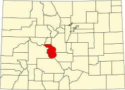
Map of Colorado highlighting Chaffee County.svg
Location within the U.S. state of Colorado
CountryFlag of the United States (23px).png  United States
State Flag of Colorado.svg  Colorado
EstablishedFebruary 10, 1879
Named for Jerome B. Chaffee
County seat Salida
Largest citySalida
Area
  Total1,015 sq mi (2,630 km2)
  Land1,013 sq mi (2,620 km2)
  Water1.6 sq mi (4 km2)  0.2%
Highest elevation
[1]
14,421 ft (4,396 m)
Population
 (2020)
  Total19,476 [2]
  Density19/sq mi (7/km2)
Time zone UTC−7 (Mountain)
  Summer (DST) UTC−6 (MDT)
Area code 970 719
FIPS code08015
GNIS feature ID 198123
Website www.chaffeecounty.org
Salida, Colorado with Sangre de Cristo Range in background Salida, Colorado with Sangre de Cristo Range in Background .jpg
Salida, Colorado with Sangre de Cristo Range in background

Chaffee County is a county located in the U.S. state of Colorado. As of the 2020 census, the population was 19,476. [2] The county seat is Salida. [3]

Contents

History

Chaffee County has a confusing origin. Between February 8 and 10, 1879, Carbonate County was created by the Colorado legislature out of northern Lake County. On February 10 the two counties were renamed, with the southern part of Lake County becoming Chaffee County, and Carbonate County becoming Lake County. Chaffee County is known as the “Heart of the Rockies”. It was named for Jerome B. Chaffee, [4] Colorado's first United States Senator.

Geography

According to the U.S. Census Bureau, the county has a total area of 1,015 square miles (2,630 km2), of which 1,013 square miles (2,620 km2) is land and 1.6 square miles (4.1 km2) (0.2%) is water. [5]

Adjacent counties

Major highways

National protected areas

Recreation area

Trails

Bicycle routes

Demographics

Historical population
CensusPop.Note
1880 6,512
1890 6,6121.5%
1900 7,0857.2%
1910 7,6227.6%
1920 7,7531.7%
1930 8,1264.8%
1940 8,109−0.2%
1950 7,168−11.6%
1960 8,29815.8%
1970 10,16222.5%
1980 13,22730.2%
1990 12,684−4.1%
2000 16,24228.1%
2010 17,8099.6%
2020 19,4769.4%
2023 (est.)20,617 [6] 5.9%
U.S. Decennial Census [7]
1790-1960 [8] 1900-1990 [9]
1990-2000 [10] 2010-2020 [2]

At the 2000 census there were 16,242 people, 6,584 households, and 4,365 families living in the county. The population density was 16 people per square mile (6.2 people/km2). There were 8,392 housing units at an average density of 8 per square mile (3.1/km2). The racial makeup of the county was 90.94% White, 1.58% Black or African American, 1.09% Native American, 0.44% Asian, 0.05% Pacific Islander, 4.21% from other races, and 1.69% from two or more races. 8.58% of the population were Hispanic or Latino of any race. [11] Of the 6,584 households 25.20% had children under the age of 18 living with them, 56.70% were married couples living together, 6.80% had a female householder with no husband present, and 33.70% were non-families. 28.40% of households were one person and 11.20% were one person aged 65 or older. The average household size was 2.26 and the average family size was 2.77.

The age distribution was 19.70% under the age of 18, 7.70% from 18 to 24, 28.00% from 25 to 44, 27.50% from 45 to 64, and 17.00% 65 or older. The median age was 42 years. For every 100 females, there were 113.60 males. For every 100 females age 18 and over, there were 116.20 males.

The median household income was $34,368 and the median family income was $42,043. Males had a median income of $30,770 versus $22,219 for females. The per capita income for the county was $19,430. About 7.40% of families and 11.70% of the population were below the poverty line, including 17.30% of those under age 18 and 10.20% of those age 65 or over.

Chaffee County is also home to a source of water that Arrowhead water uses for some water bottles. The source is Ruby Mountain Springs.

Politics

Chaffee County is a bellwether county, having supported the winner of 8 out of the last 11 presidential elections. The most recent election where Chaffee County supported the presidential loser was in 2008, when John McCain won the county despite Barack Obama winning decisively nationally and statewide.

United States presidential election results for Chaffee County, Colorado [12]
Year Republican Democratic Third party
No.%No.%No.%
2020 6,22245.36%7,16052.19%3362.45%
2016 5,39147.92%4,88843.45%9718.63%
2012 5,07048.46%5,08648.61%3062.92%
2008 4,87349.12%4,86249.01%1861.87%
2004 4,87555.59%3,76642.94%1291.47%
2000 4,30056.50%2,76836.37%5427.12%
1996 3,05246.85%2,76842.49%69510.67%
1992 2,41938.51%2,28436.36%1,57925.14%
1988 3,08053.90%2,54844.59%861.51%
1984 3,68066.31%1,77932.05%911.64%
1980 3,32760.73%1,58328.90%56810.37%
1976 2,92556.66%2,06439.98%1733.35%
1972 2,85966.63%1,35431.55%781.82%
1968 2,12151.07%1,66740.14%3658.79%
1964 1,47637.36%2,46362.34%120.30%
1960 2,09452.14%1,91847.76%40.10%
1956 2,28463.67%1,30336.33%00.00%
1952 2,17156.70%1,64342.91%150.39%
1948 2,06557.68%1,47641.23%391.09%
1944 1,67548.83%1,73150.47%240.70%
1940 1,93346.91%2,15352.24%350.85%
1936 1,06929.18%2,44766.78%1484.04%
1932 1,06129.24%2,39365.96%1744.80%
1928 1,88059.49%1,23038.92%501.58%
1924 1,33643.40%61219.88%1,13036.71%
1920 1,50152.91%1,23343.46%1033.63%
1916 86424.59%2,54672.47%1032.93%
1912 72321.30%1,64148.34%1,03130.37%
1908 1,23338.23%1,67952.06%3139.71%
1904 1,61146.90%1,60146.61%2236.49%
1900 1,03334.41%1,89062.96%792.63%
1896 1415.10%2,60694.35%150.54%
1892 67840.12%00.00%1,01259.88%
1888 1,27756.21%94141.42%542.38%
1884 1,14253.46%98646.16%80.37%
1880 1,13548.50%1,18850.77%170.73%

Communities

Chaffee County, Colorado Map of Chaffee County, Colorado.png
Chaffee County, Colorado
Buffalo Peaks near Buena Vista Buffalo Peaks outside of Buena Vista.jpg
Buffalo Peaks near Buena Vista

City

Towns

Census-designated places

Unincorporated communities

Ghost towns

See also

Related Research Articles

<span class="mw-page-title-main">Yuma County, Colorado</span> County in Colorado, United States

Yuma County is a county located in the U.S. state of Colorado. As of the 2020 census, the population was 9,988. The county seat is Wray.

<span class="mw-page-title-main">Saguache County, Colorado</span> County in Colorado, United States

Saguache County is a county located in the U.S. state of Colorado. As of the 2020 census, the population was 6,368. The county seat is Saguache.

<span class="mw-page-title-main">Rio Grande County, Colorado</span> County in Colorado, United States

Rio Grande County is a county located in the U.S. state of Colorado. As of the 2020 census, the population was 11,539. The county seat is Del Norte. The county is named for the Rio Grande, which flows through the county.

<span class="mw-page-title-main">Phillips County, Colorado</span> County in Colorado, United States

Phillips County is a county located in the U.S. state of Colorado. As of the 2020 census, the population was 4,530. The county seat is Holyoke. The county was named in honor of R.O. Phillips, a secretary of the Lincoln Land Company, who organized several towns in Colorado.

<span class="mw-page-title-main">Park County, Colorado</span> County in Colorado, United States

Park County is a county located in the U.S. state of Colorado. As of the 2020 census, the population was 17,390. The county seat is Fairplay. The county was named after the large geographic region known as South Park, which was named by early fur traders and trappers in the area.

<span class="mw-page-title-main">Otero County, Colorado</span> County in Colorado, United States

Otero County is a county located in the U.S. state of Colorado. As of the 2020 census, the population was 18,690. The county seat is La Junta. The county was named for Miguel Antonio Otero, one of the founders of the town of La Junta and a member of a prominent Hispanic family.

<span class="mw-page-title-main">Morgan County, Colorado</span> County in Colorado, United States

Morgan County is a county located in the U.S. state of Colorado. As of the 2020 census, the population was 29,111. The county seat is Fort Morgan. The county was named after old Fort Morgan, which in turn was named in honor of Colonel Christopher A. Morgan.

<span class="mw-page-title-main">Mineral County, Colorado</span> County in Colorado, United States

Mineral County is a county located in the U.S. state of Colorado. As of the 2020 census, the population was 865, making it the third-least populous county in Colorado, behind San Juan County and Hinsdale County. The county seat and only incorporated municipality in the county is Creede. The county was named for the many valuable minerals found in the mountains and streams of the area.

<span class="mw-page-title-main">Las Animas County, Colorado</span> County in Colorado, United States

Las Animas County is a county located in the U.S. state of Colorado. As of the 2020 census, the population was 14,555. The county seat is Trinidad. The county takes its name from the Mexican Spanish name of the Purgatoire River, originally called El Río de las Ánimas Perdidas en el Purgatorio, which means "River of the Lost Souls in Purgatory."

<span class="mw-page-title-main">Lake County, Colorado</span> County in Colorado, United States

Lake County is a county located in the U.S. state of Colorado. As of the 2020 census, the population was 7,436. The county seat and the only municipality in the county is Leadville. The highest natural point in Colorado and the entire Rocky Mountains is the summit of Mount Elbert in Lake County at 14,440 feet elevation.

<span class="mw-page-title-main">Grand County, Colorado</span> County in Colorado, United States

Grand County is a county located in the U.S. state of Colorado. As of the 2020 census, the population was 15,717. The county seat is Hot Sulphur Springs.

<span class="mw-page-title-main">Gilpin County, Colorado</span> County in Colorado, United States

Gilpin County is a county located in the U.S. state of Colorado, smallest in land area behind only the City and County of Broomfield. As of the 2020 census, the population was 5,808. The county seat is Central City. The county was formed in 1861, while Colorado was still a territory, and was named after Colonel William Gilpin, the first territorial governor.

<span class="mw-page-title-main">Fremont County, Colorado</span> County in Colorado, United States

Fremont County is a county located in the U.S. state of Colorado. As of the 2020 census, the population was 48,939. The county seat is Cañon City. The county is named for 19th-century explorer and presidential candidate John C. Frémont.

<span class="mw-page-title-main">Elbert County, Colorado</span> County in the United States

Elbert County is a county located in the U.S. state of Colorado. As of the 2020 census, the population was 26,062. The county seat is Kiowa and the largest town is Elizabeth.

<span class="mw-page-title-main">Eagle County, Colorado</span> County in Colorado, United States

Eagle County is a county located in the U.S. state of Colorado. As of the 2020 census, the population was 55,731. The county seat is the Town of Eagle and the most populous community is Edwards. The county is named for the Eagle River.

<span class="mw-page-title-main">Delta County, Colorado</span> County in Colorado, United States

Delta County is a county located in the U.S. state of Colorado. As of the 2020 census, the population was 31,196. The county seat is Delta.

<span class="mw-page-title-main">Crowley County, Colorado</span> County in Colorado, United States

Crowley County is a county in Colorado. As of the 2020 census, the population was 5,922. The county seat is Ordway.

<span class="mw-page-title-main">Bent County, Colorado</span> County in Colorado, United States

Bent County is a county located in the U.S. state of Colorado. As of the 2020 census, the population was 5,650. The county seat and only incorporated municipality is Las Animas. The county is named in honor of frontier trader William Bent.

<span class="mw-page-title-main">Alamosa County, Colorado</span> County in Colorado, United States

Alamosa County is a county located in the U.S. state of Colorado. As of the 2020 census, the population was 16,376. The county seat is Alamosa. The county name is the Spanish language word for a grove of cottonwood trees.

<span class="mw-page-title-main">Buena Vista, Colorado</span> Town in Colorado, United States

Buena Vista is a Statutory Town located in Chaffee County, Colorado, United States. The town population was 2,855 at the 2020 United States Census.

References

  1. Mount Harvard
  2. 1 2 3 "U.S. Census Bureau QuickFacts". U.S. Census Bureau . Retrieved September 4, 2021.
  3. "Find a County". National Association of Counties. Archived from the original on May 31, 2011. Retrieved June 7, 2011.
  4. Gannett, Henry (1905). The Origin of Certain Place Names in the United States. Govt. Print. Off. pp.  74.
  5. "US Gazetteer files: 2010, 2000, and 1990". United States Census Bureau. February 12, 2011. Retrieved April 23, 2011.
  6. "Annual Estimates of the Resident Population for Counties: April 1, 2020 to July 1, 2023". United States Census Bureau. Retrieved March 31, 2024.
  7. "U.S. Decennial Census". United States Census Bureau. Retrieved June 7, 2014.
  8. "Historical Census Browser". University of Virginia Library. Archived from the original on June 23, 2018. Retrieved June 7, 2014.
  9. "Population of Counties by Decennial Census: 1900 to 1990". United States Census Bureau. Retrieved June 7, 2014.
  10. "Census 2000 PHC-T-4. Ranking Tables for Counties: 1990 and 2000" (PDF). United States Census Bureau. Archived (PDF) from the original on March 27, 2010. Retrieved June 7, 2014.
  11. "U.S. Census website". United States Census Bureau . Retrieved May 14, 2011.
  12. Leip, David. "Dave Leip's Atlas of U.S. Presidential Elections". uselectionatlas.org. Retrieved May 26, 2017.

38°44′N106°11′W / 38.74°N 106.18°W / 38.74; -106.18