
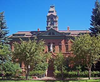
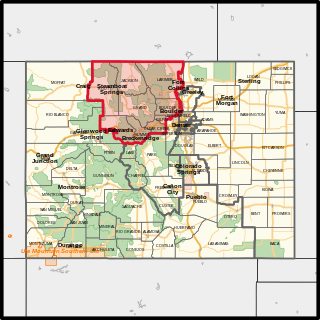
Routt County is a county located in the U.S. state of Colorado. As of the 2020 census, the population was 24,829. The county seat is Steamboat Springs. Routt County comprises the Steamboat Springs, CO Micropolitan Statistical Area.
Pitkin County is a county in the U.S. state of Colorado. As of the 2020 census, the population was 17,358. The county seat and largest city is Aspen. The county is named for Colorado Governor Frederick Walker Pitkin.

Park County is a county located in the U.S. state of Colorado. As of the 2020 census, the population was 17,390. The county seat is Fairplay. The county was named after the large geographic region known as South Park, which was named by early fur traders and trappers in the area.
Moffat County is a county located in the U.S. state of Colorado. As of the 2020 census, the population was 13,292. The county seat is Craig. With an area of 4,751 square miles, it is the second-largest county by area in Colorado, behind Las Animas County.

Garfield County is a county located in the U.S. state of Colorado. As of the 2020 census, the population was 61,685. The county seat is Glenwood Springs. The county is named in honor of United States President James A. Garfield. Garfield County is included in the Glenwood Springs, CO Micropolitan Statistical Area, which is also included in the Edwards-Glenwood Springs, CO Combined Statistical Area.

Eagle County is a county located in the U.S. state of Colorado. As of the 2020 census, the population was 55,731. The county seat is the Town of Eagle and the most populous community is Edwards. The county is named for the Eagle River.

Delta County is a county located in the U.S. state of Colorado. As of the 2020 census, the population was 31,196. The county seat is Delta.

Cheyenne County is a county located in the U.S. state of Colorado. The county population was 1,748 at 2020 census. The county seat is Cheyenne Wells.

Wray is the home rule municipality that is the county seat of Yuma County, Colorado, United States. Located in the Colorado Plains, the city is 170 miles east of Denver, 9 miles west of the Nebraska state line, and 25 miles northwest of the Kansas state line. The population was 2,358 at the 2020 United States census.
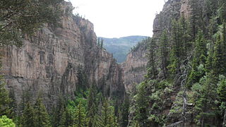
Glenwood Canyon is a rugged scenic 12.5 mi (20 km) canyon in western Colorado in the United States. Its walls climb as high as 1,300 feet (400 m) above the Colorado River. It is the largest such canyon on the Upper Colorado. The canyon, which has historically provided the routes of railroads and highways through western Colorado, currently furnishes the routes of Interstate 70 and the Union Pacific's Central Corridor between Denver and Grand Junction.
Southwestern Colorado is a region in the southwest portion of Colorado, which in turn is part of the larger Four Corners region. It is bordered by Western Colorado, Southern Colorado, the south portion of Central Colorado, Utah, and New Mexico.

Browns Park National Wildlife Refuge is a 13,450-acre (5,440 ha) U.S. National Wildlife Refuge located in northwestern Colorado. It is located in Moffat County in the extreme northwestern corner of the state, in an isolated mountain valley of Browns Park on both sides of the Green River, approximately 25 miles (40 km) below Flaming Gorge Dam. Established in 1965, the refuge is managed by the United States Fish and Wildlife Service office in Maybell, Colorado. The refuge is approximately 53 miles (85 km) northwest of Maybell on State Highway 318. The refuge consists of bottomland and adjacent benchland. The western border of the refuge is the Colorado-Utah state line. The refuge is surrounded by adjacent lines of the Bureau of Land Management. The refuge contains the site of the former Fort Davy Crockett that was constructed in 1837 to protect trappers against attacks by Blackfoot Native Americans.

The Arizona Strip is the part of Arizona lying north of the Colorado River. Despite being larger in area than several U.S. states, the entire region has a population of fewer than 10,000 people. Consisting of northeastern Mohave County and northwestern Coconino County, the largest settlements in the Strip are Colorado City, Fredonia, and Beaver Dam, with smaller communities of Scenic, Littlefield and Desert Springs. The Kaibab Indian Reservation lies within the region. Lying along the North Rim of the Grand Canyon creates physical barriers to the rest of Arizona. Only three major roads traverse the region, I-15 crosses the northwestern corner while Arizona State Route 389 and U.S. Route 89A crosses the northeastern part of the strip, US 89A crosses the Colorado River via the Navajo Bridge, providing the only direct road connection between the strip and the rest of the state. The nearest metropolitan area is the St. George, Utah metro area, to which the region is more connected than to the rest of Arizona.
Colorado's 2nd congressional district is a congressional district in the U.S. state of Colorado. The district is located in the north-central part of the state and encompasses the northwestern suburbs of Denver including Boulder and Fort Collins. The district also includes the mountain towns of Vail, Granby, Steamboat Springs, and Idaho Springs. Redistricting in 2011 moved Larimer County, including the cities of Fort Collins and Loveland, to the 2nd from the 4th district. Meanwhile, redistricting in 2021 moved Loveland back to the 4th district and Broomfield and western Jefferson County to the 7th district.

The West Mesa is an elevated landmass lying west of the Rio Grande in the Albuquerque area, stretching from the Pajarito Mesa in the South Valley northward to Bernalillo in the U.S. state of New Mexico.
The Belmont Mountains are a 25 mi (40 km) long, arid, low elevation mountain range about 50 mi west of Phoenix, Arizona in the northern Sonoran Desert, north of the Gila River. The range is in the south of a region of two parallel washes; the Bouse Wash flows northwest to the Colorado River, and the Centennial Wash flows southeast to meet the Gila River.

The Mountain states form one of the nine geographic divisions of the United States that are officially recognized by the United States Census Bureau. It is a subregion of the Western United States.

The southwestern tablelands comprise an ecoregion running from east-central to south-east Colorado, east-central and a small portion of eastern New Mexico, some eastern portions of the Oklahoma Panhandle, far south-central Kansas, and portions of northwest Texas. This ecoregion has a "cold semiarid" climate. Some years, a National Weather Service dust storm warning is issued in parts of Texas due to a dust storm originating from the lower part of the Southwestern Tablelands ecological region or from the southern end of the Western High Plains ecological region.
The White River Plateau is a "broad structural dome" located north of Glenwood Springs, Colorado and north of the Colorado River. Also called the White River Uplift, the mountainous area is shown on maps as being roughly circular in area, occupying parts of the Colorado counties of Garfield and Rio Blanco, with small portions extending into Eagle and Routt counties. The Grand Hogback marks parts of the plateau's southern and western boundaries. The Flat Tops mountain range is part of the White River Plateau, and much of the plateau is located within the White River National Forest.
Irish Canyon is a valley in Moffat County in the northwest portion of the U.S. state of Colorado, at 6,099 feet in elevation according to the United States Geological Survey (USGS). The Bureau of Land Management states the elevation in the valley rises from 6,100 to 8,636 feet. It is a scenic and somewhat remote canyon. It is designated both as the Irish Canyon Natural Area and the Irish Canyon Area of Critical Environmental Concern.
