This article needs additional citations for verification .(November 2009) |
The Eastern Plains of Colorado refers to a region of the U.S. state of Colorado east of the Rocky Mountains and east of the population centers of the Front Range.
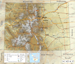
The Eastern Plains are part of the High Plains, which are the westernmost portion of the Great Plains. The region is characterized by mostly rolling plains, divided by the South Platte River and Arkansas River valleys. There are also several deciduous forests, canyons, buttes, and a few large natural lakes and rivers throughout the region. The Eastern Plains rise from approximately 3,400 feet (1,000 m.) at the eastern border of Colorado with Kansas, where the Arkansas River leaves the state, to 7,500 feet (2,300 m.)[ citation needed ] east of the Denver Basin. [1]
Most of the Eastern Plains region lies within Colorado's 4th congressional district.
The Eastern Plains have a semi-arid climate and receive little rainfall. [2] Much of the area relies on irrigation to survive. Summers are typically hot and dry, often bringing thunderstorms, which are often severe, to the area, with some occasionally forming landspouts and tornadoes. Eastern Colorado winters are cold and dry, with significant snowfalls and icy conditions. Temperatures can sometimes fall to -40 to -30 degrees Fahrenheit in extreme cold waves, although this is rare. [3]
Eastern Colorado was once home to many Native American tribes. The Plains Indians that lived in the region included the Arapahoe, Cheyenne, Kiowa, Pawnee, and Sioux. [4] The Ute people formally ruled all over central and western Colorado, and onto the eastern plains as well. The Comanche once ruled all over southeastern Colorado, and the Jicarilla Apache ruled in southeastern Colorado as well. [5]
In 1541, the Spanish came to the area now known as the south eastern portion of Colorado, in search of gold after hearing rumors in Mexico city. Not having found any gold, the Spanish largely left the area untouched. During the late 17th and 18th century Spain and France claimed southeastern Colorado. However, nobody settled the land. In 1803 the United States gained possession of much of the land east of Rocky Mountains with the Louisiana Purchase.
Zebulon M. Pike was sent by the federal government to lay out the boundary lines of territory in 1806. This expedition investigated the area now known as Colorado Springs. The prominent mountain in the area was named Pike's Peak after Pike, the leading commander of the exploration. There were multiple expeditions sent to lay out and explore the territory throughout the early 1800s. This created multiple trading posts with fur trades attracting many backcountry adventurers. There was still no permanent settlement created until after the conclusion of the Mexican War in 1848. San Luis was founded on the Culebra River in 1851. Spanish-speaking settlers who had moved north from New Mexico founded it. San Luis was shortly followed by settlements of San Pedro, San Acacio and Guadalupe. [6]
The Eastern Colorado plains are among the most sparsely populated areas in the continental United States. Some of the region, with the exception of comparatively urban areas like Sterling, is experiencing depopulation, which in some areas began with the influenza pandemic of 1918 and agricultural price collapses after World War I. [7] The Dust Bowl devastated the region and further accelerated this outmigration. Baca County is emblematic of the population decline and its associated effects, as the county's population declined in every census from 1960 to 2020.
Both the Pawnee National Grasslands and Comanche National Grasslands are located in the Eastern Plains. They are composed of marginal farmlands that were withdrawn from agriculture and consolidated under federal control beginning in the Dust Bowl. [8]
The Amache National Historic Site, located near Granada in Prowers County is administered by the National Park Service. [9]
Eastern Colorado is largely farmland, with many small farming communities. The major cash crops are corn, wheat, hay, oats, and soybeans. [10] There is also significant livestock farming, dairy and poultry farming, including chicken for meat and eggs, and turkey farming. Most of the towns in the region have grain elevators and prominent water towers. [10] Also, over 90% of the farms in Eastern Colorado are family farms.
In Eastern Colorado most small towns have their own schools and sports teams, but in some parts where depopulation has been the worst, a single school is shared among surrounding towns. There are also a number of schools serving students in grades K–12 run by religious groups or public school districts. Eastern Colorado is one of the few remaining places in the United States that was still operating one-room school houses in 2010. [11]
Eastern Colorado is home to several institutions of higher education, primarily community colleges. These include Morgan Community College in Fort Morgan, Northeastern Junior College in Sterling, Lamar Community College in Lamar, and Otero College in La Junta.
The most prominent religion in Eastern Colorado is Christianity, with Roman Catholicism the largest denomination.[ citation needed ]
Eastern Colorado roads span the gamut from paved roads to gravel roads to dirt roads. The unpaved roads are typically county or local roads that do not receive enough traffic to be paved. Some of the major paved roads include:
Colorado is a landlocked state in the Mountain West subregion of the Western United States. Colorado borders Wyoming to the north, Nebraska to the northeast, Kansas to the east, Oklahoma to the southeast, New Mexico to the south, Utah to the west, and meets Arizona to the southwest at the Four Corners. Colorado is noted for its landscape of mountains, forests, high plains, mesas, canyons, plateaus, rivers, and desert lands. Colorado is one of the Mountain States and is often considered to be part of the southwestern United States. The high plains of Colorado may be considered a part of the midwestern United States. It encompasses most of the Southern Rocky Mountains, as well as the northeastern portion of the Colorado Plateau and the western edge of the Great Plains. Colorado is the eighth most extensive and 21st most populous U.S. state. The United States Census Bureau estimated the population of Colorado at 5,877,610 as of July 1, 2023, a 1.80% increase since the 2020 United States census.
The Great Plains, sometimes simply "the Plains", is a broad expanse of flatland in North America. It is located just to the east of the Rocky Mountains, much of it covered in prairie, steppe, and grassland. It is the western part of the Interior Plains, which also include the mixed grass prairie, the tallgrass prairie between the Great Lakes and Appalachian Plateau, and the Taiga Plains and Boreal Plains ecozones in Northern Canada. Great Plains or Western Plains is also used to describe the ecoregion of the Great Plains, or alternatively the western portion of the Great Plains.
The Smoky Hill River is a 575-mile (925 km) river in the central Great Plains of North America, running through Colorado and Kansas.
The Territory of Colorado was an organized incorporated territory of the United States that existed from February 28, 1861, until August 1, 1876, when it was admitted to the Union as the State of Colorado.
State Highway 14 in the U.S. state of Colorado is an east–west state highway approximately 237 miles (381 km) long, making it the longest state highway in Colorado. It traverses four counties along the northern edge of the state, spanning a geography from the continental divide in the Rocky Mountains to the Great Plains, and including North Park, the Poudre Canyon, and the Pawnee National Grassland. It provides the most direct route from Fort Collins westward via Cameron Pass to Walden and Steamboat Springs, and eastward across the plains to Sterling.
Pawnee National Grassland is a United States National Grassland located in northeastern Colorado on the Colorado Eastern Plains. The grassland is located in the South Platte River basin in remote northern and extreme northeastern Weld County between Greeley and Sterling. It comprises two parcels totaling 193,060 acres (78,130 ha) largely between State Highway 14 and the Wyoming border. The larger eastern parcel lies adjacent to the borders of both Nebraska and Wyoming. It is administered in conjunction with the Arapaho-Roosevelt National Forest from the U.S. Forest Service office in Fort Collins, with a local ranger district office in Greeley.
The Roosevelt National Forest is a National Forest located in north central Colorado. It is contiguous with the Colorado State Forest as well as the Arapaho National Forest and the Routt National Forest. The forest is administered jointly with the Arapaho National Forest and the Pawnee National Grassland from offices in Fort Collins, and is denoted by the United States Forest Service as ARP.
The Texas Blackland Prairies are a temperate grassland ecoregion located in Texas that runs roughly 300 miles (480 km) from the Red River in North Texas to San Antonio in the south. The prairie was named after its rich, dark soil. Less than 1% of the original Blackland prairie vegetation remains, scattered across Texas in parcels.
Cimarron National Grassland is a National Grassland located in Morton County, Kansas, United States, with a very small part extending eastward into Stevens County. Cimarron National Grassland is located near Comanche National Grassland which is across the border in Colorado. The grassland is administered by the Forest Service together with the Pike and San Isabel National Forests and the Comanche National Grassland, from common headquarters located in Pueblo, Colorado. There are local ranger district offices in Elkhart, Kansas. The grassland is the largest area of public land in the state of Kansas.
El Cuartelejo, or El Quartelejo, is a region in eastern Colorado and western Kansas where Plains Apache cohabited with Puebloans. Subject to religious persecution, Puebloans fled the Spanish Nuevo México territory and cohabitated with the Cuartelejo villagers in the 1600s.
Comanche National Grassland is a National Grassland located in southeastern Colorado, United States. It is the sister grassland of Cimarron National Grassland and contains both prairie grasslands and canyons. It is separated into two sections, each operated by a local ranger district, one of which is in Springfield and the other of which is in La Junta. The grassland is administered by the Forest Service together with the Pike and San Isabel National Forests, and the Cimarron National Grassland, from common headquarters located in Pueblo, Colorado.
The term Cross Timbers, also known as Ecoregion 29, Central Oklahoma/Texas Plains, is used to describe a strip of land in the United States that runs from southeastern Kansas across Central Oklahoma to Central Texas. Made up of a mix of prairie, savanna, and woodland, it forms part of the boundary between the more heavily forested eastern country and the almost treeless Great Plains, and also marks the western habitat limit of many mammals and insects.
The geography of the U.S. State of Colorado is diverse, encompassing both rugged mountainous terrain, vast plains, desert lands, desert canyons, and mesas. Colorado is a landlocked U.S. state. In 1861, the United States Congress defined the boundaries of the new Territory of Colorado exclusively by lines of latitude and longitude, stretching from 37°N to 41°N latitude, and from 102°02'48"W to 109°02'48"W longitude. Starting in 1868, official surveys demarcated the boundaries, deviating from the parallels and meridians in several places. Later surveys attempted to correct some of these mistakes but in 1925 the U.S. Supreme Court affirmed that the earlier demarcation was the official boundary. The borders of Colorado are now officially defined by 697 boundary markers connected by straight boundary lines. Colorado, Wyoming, and Utah are the only states that have their borders defined solely by straight boundary lines with no natural features. The southwest corner of Colorado is the Four Corners Monument at 36°59'56"N, 109°2'43"W. This is the only place in the United States where four states meet: Colorado, New Mexico, Arizona, and Utah.
The Purgatoire River, also known as the Purgatory and Picketwire River, is in southeastern Colorado, United States. The river originates in the high mountains of the Culebra Range. Several tributaries merge near Weston in Las Animas County and the river flows east-northeastward 196 miles (315 km) to a confluence with the Arkansas River near Las Animas in Bent County, Colorado. The Purgatoire River drains an area of 3,449 square miles (8,930 km2), mostly in Colorado but a small percentage of the watershed is in New Mexico. The Purgatoire River watershed is lightly populated. Population has been declining since 1920 as former coal mining and agricultural communities have become ghost towns.
This is an alphabetical list of articles related to the U.S. State of Colorado.
The Santa Fe Trail Scenic and Historic Byway is a 188-mile (303 km) National Scenic Byway and Colorado Scenic and Historic Byway located in Prowers, Bent, Otero, and Las Animas counties, Colorado, USA. The byway follows the Santa Fe National Historic Trail through southeastern Colorado and connects to the 381-mile (613 km) Santa Fe Trail Scenic Byway in New Mexico at Raton Pass, a National Historic Landmark at elevation 7,834 feet (2,388 m). The byway visits Amache National Historic Site and Bent's Old Fort National Historic Site, both National Historic Landmarks, and winds between the Spanish Peaks and Raton Mesa, both National Natural Landmarks.
Prehistory of Colorado provides an overview of the activities that occurred prior to Colorado's recorded history. Colorado experienced cataclysmic geological events over billions of years, which shaped the land and resulted in diverse ecosystems. The ecosystems included several ice ages, tropical oceans, and a massive volcanic eruption. Then, ancient layers of earth rose to become the Rocky Mountains.
The Purgatoire River track site, also called the Picketwire Canyonlands tracksite, is one of the largest dinosaur tracksites in North America. The site is located on public land of the Comanche National Grassland, along the Purgatoire ("Picketwire") River south of La Junta in Otero County, Colorado.
{{cite web}}
: CS1 maint: archived copy as title (link)