Nathrop, Colorado

Last updated

Nathrop, Colorado
Nathrop, Colorado.JPG
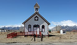
An old school in Nathrop.
USA Colorado location map.svg
Red pog.svg
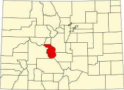
Nathrop
Location of the Nathrop CDP in the State of Colorado.
Coordinates: 38°44′55″N106°04′35″W / 38.7487401°N 106.0764200°W / 38.7487401; -106.0764200 (Nathrop CDP, Colorado) [1]
Country Flag of the United States.svg  United States
State Flag of Colorado.svg  Colorado
County Chaffee County
Government
[2]
  Type unincorporated town
Area
[1]
  Total0.723 sq mi (1.873 km2)
  Land0.723 sq mi (1.873 km2)
  Water0.000 sq mi (0.000 km2)
Elevation
[2]
7,680 ft (2,341 m)
Population
 (2020) [3]
  Total288
  Density400/sq mi (150/km2)
Time zone UTC-7 (MST)
  Summer (DST) UTC-6 (MDT)
ZIP Code [4]
81236
Area code 719
GNIS feature [2] Nathrop CDP

Nathrop is an unincorporated town, a post office, and a census-designated place (CDP) located in and governed by Chaffee County, Colorado, United States. The population was 288 at the 2020 census. [3] The Nathrop post office has the ZIP code 81236. [4]

Contents

History

Nathrop was named for Charles Nachtrieb, owner of the townsite. [2] [5] In 1880, the Denver and Rio Grande Railroad built through Nathrop as part of their Tennessee Pass line. The tracks were placed out of service in 1997, but Union Pacific, present-day owner of the line, may reach an agreement to reopen it.

Geography

The Nathrop CDP has an area of 463 acres (1.873 km2), all land. [1]

Ruby Mountain

Ruby Mountain is a rhyolite outcrop located about one mile northeast of Nathrop. Small spessartite garnet crystals are found throughout the outcropping. Small pebbles of black obsidian referred to as "Apache tears" by collectors can also be found in the talus rock at the base of the cliffs. [6]

Spessartine-49374 Spessartine-49374.jpg
Spessartine-49374

Demographics

The United States Census Bureau defined the Nathrop CDP for the United States Census 2020.

Nathrop CDP, Colorado
YearPop.±%
2020 288    
Source: United States Census Bureau

Attractions

See also

Related Research Articles

<span class="mw-page-title-main">Chaffee County, Colorado</span> County in Colorado, United States

Chaffee County is a county located in the U.S. state of Colorado. As of the 2020 census, the population was 19,476. The county seat is Salida.

<span class="mw-page-title-main">Strasburg, Colorado</span> Census Designated Place in Colorado, United States

Strasburg is an unincorporated town located just 30 minutes east of downtown Denver along the I-70 corridor. It is home to Strasburg School District 31-J, and there are several small businesses, medical clinics, and a post office. Strasburg is a census-designated place (CDP) located in and governed by Adams and Arapahoe counties, Colorado, United States. The CDP is a part of the Denver–Aurora–Lakewood, CO Metropolitan Statistical Area. The Strasburg post office has the ZIP Code 80136. At the United States Census 2020, the population of the Strasburg CDP was 3,307.

<span class="mw-page-title-main">Byers, Colorado</span> Census Designated Place in Colorado, United States

Byers is an unincorporated town, a post office, and a census-designated place (CDP) located in and governed by Arapahoe County, Colorado, United States. The CDP is a part of the Denver–Aurora–Lakewood, CO Metropolitan Statistical Area. The Byers post office has the ZIP Code 80103. At the United States Census 2020, the population of the Byers CDP was 1,322.

<span class="mw-page-title-main">Coal Creek, Jefferson County, Colorado</span> Census-designated place in Boulder, Gilpin, and Jefferson counties in Colorado, United States

Coal Creek, commonly known as Coal Creek Canyon, is a census-designated place (CDP) located in and governed by Jefferson, Boulder, and Gilpin counties in Colorado, United States, but primarily Jefferson County. The population of the Coal Creek CDP was 2,494 at the United States Census 2020. The Golden post office serves the area.

<span class="mw-page-title-main">Eldorado Springs, Colorado</span> Census-designated place in Colorado, United States

Eldorado Springs is an unincorporated community, a census-designated place (CDP) and a post office located in and governed by Boulder County, Colorado, United States. The CDP is a part of the Boulder, CO Metropolitan Statistical Area. The Eldorado Springs post office has the ZIP code 80025. At the 2020 United States census, the population of the Eldorado Springs CDP was 559.

<span class="mw-page-title-main">Salida, Colorado</span> City in Colorado, United States

Salida is the statutory city that is the county seat and the most populous municipality of Chaffee County, Colorado, United States. The population was 5,666 at the 2020 census.

<span class="mw-page-title-main">Highlands Ranch, Colorado</span> Census Designated Place in Colorado, United States

Highlands Ranch is an unincorporated community and a census-designated place (CDP) located in and governed by Douglas County, Colorado, United States. The CDP is a part of the Denver–Aurora–Lakewood, CO Metropolitan Statistical Area. The population of the Highlands Ranch CDP was 105,631 at the United States Census 2020, making it the most populous unincorporated community in the State of Colorado. The Highlands Ranch Metropolitan District provides services to the community, which lies in ZIP Codes 80126, 80129, 80130, and 80163.

<span class="mw-page-title-main">Applewood, Colorado</span> Census Designated Place in Colorado, United States

Applewood is an unincorporated community and a census-designated place (CDP) located in and governed by Jefferson County, Colorado, United States. The CDP is a part of the Denver–Aurora–Lakewood, CO Metropolitan Statistical Area. The population of the Applewood CDP was 7,833 at the 2020 United States Census. The Golden post office serves the area.

<span class="mw-page-title-main">Evergreen, Colorado</span> Census Designated Place in Colorado, United States

Evergreen is an unincorporated town, a post office, and a census-designated place (CDP) located in and governed by Jefferson County, Colorado, U.S. The CDP is a part of the Denver–Aurora–Lakewood, CO Metropolitan Statistical Area. The Evergreen post office has the ZIP Codes 80439 and 80437. At the 2020 census, the population of the Evergreen CDP was 9,307. The Evergreen Metropolitan District provides services.

<span class="mw-page-title-main">Kittredge, Colorado</span> Census Designated Place in Colorado, United States

Kittredge is an unincorporated town, a post office, and a census-designated place (CDP) located in and governed by Jefferson County, Colorado, United States. The CDP is a part of the Denver–Aurora–Lakewood, CO Metropolitan Statistical Area. The Kittredge post office has the ZIP code 80457. At the United States Census 2020, the population of the Kittredge CDP was 1,308.

<span class="mw-page-title-main">Rollinsville, Colorado</span> Census-designated place in Gilpin County, Colorado, United States

Rollinsville is a census-designated place (CDP) and post office in and governed by Gilpin County, Colorado, United States. The CDP is a part of the Denver–Aurora–Lakewood, CO Metropolitan Statistical Area. The Rollinsville post office has the ZIP Code 80474. At the United States Census 2020, the population of the Rollinsville CDP was 194.

<span class="mw-page-title-main">Heeney, Colorado</span> Census Designated Place in Colorado, United States

Heeney is an unincorporated community and a census-designated place (CDP) located in and governed by Summit County, Colorado, United States. The CDP is a part of the Breckenridge, CO Micropolitan Statistical Area. The population of the Heeney CDP was 74 at the United States Census 2020. The Silverthorne post office (Zip Code 80498) serves Heeney postal addresses.

<span class="mw-page-title-main">Johnson Village, Colorado</span> Census Designated Place in Colorado, United States

Johnson Village is an unincorporated community and a census-designated place (CDP) located in and governed by Chaffee County, Colorado, United States. The population of the Johnson Village CDP was 299 at the United States Census 2020. The Buena Vista post office serves the area.

<span class="mw-page-title-main">Divide, Colorado</span> Census Designated Place in Colorado, United States

Divide is an unincorporated town, a post office, and a census-designated place (CDP) located in and governed by Teller County, Colorado, United States. The CDP is a part of the Colorado Springs, CO Metropolitan Statistical Area. The Divide post office has the ZIP Code 80814. At the United States Census 2020, the population of the Divide CDP was 143.

<span class="mw-page-title-main">Howard, Colorado</span> Census-designated place in Fremont County, Colorado, United States

Howard is a census-designated place (CDP) and post office in and governed by Fremont County, Colorado, United States. The CDP is a part of the Cañon City, CO Micropolitan Statistical Area. The Howard post office has the ZIP Code 81233. At the United States Census 2020, the population of the Howard CDP was 852.

<span class="mw-page-title-main">Idledale, Colorado</span> Census Designated Place in Colorado, United States

Idledale is an unincorporated town, a post office, and a census-designated place (CDP) located in and governed by Jefferson County, Colorado, United States. The CDP is a part of the Denver–Aurora–Lakewood, CO Metropolitan Statistical Area. The Idledale post office has the ZIP code 80453. At the United States Census 2020, the population of the Idledale CDP was 244.

<span class="mw-page-title-main">Matheson, Colorado</span> Census-designated place in Elbert County, Colorado, United States.

Matheson is a census-designated place (CDP) and post office in and governed by Elbert County, Colorado, United States. The CDP is a part of the Denver–Aurora–Lakewood, CO Metropolitan Statistical Area. The Matheson post office has the ZIP Code 80830. At the United States Census 2020, the population of the Matheson CDP was 79.

<span class="mw-page-title-main">Garfield, Colorado</span> Census Designated Place in Colorado, United States

Garfield is an unincorporated community and a census-designated place (CDP) located in and governed by Chaffee County, Colorado, United States. The population of the Garfield CDP was 27 at the United States Census 2020. The Salida post office serves the area.

<span class="mw-page-title-main">Smeltertown, Colorado</span> Census Designated Place in Colorado, United States

Smeltertown is an unincorporated community and a census-designated place (CDP) located in and governed by Chaffee County, Colorado, United States. The population of the Smeltertown CDP was 88 at the United States Census 2020. The Salida post office serves the area.

References

  1. 1 2 3 "State of Colorado Census Designated Places - BAS20 - Data as of January 1, 2020". United States Census Bureau . Retrieved December 6, 2020.
  2. 1 2 3 4 "U.S. Board on Geographic Names: Domestic Names". United States Geological Survey . Retrieved December 20, 2020.
  3. 1 2 United States Census Bureau. "Nathrop CDP, Colorado" . Retrieved April 9, 2023.
  4. 1 2 "Look Up a ZIP Code". United States Postal Service . Retrieved December 20, 2020.
  5. Dawson, John Frank (1954). Place names in Colorado: why 700 communities were so named, 150 of Spanish or Indian origin. Denver, CO: The J. Frank Dawson Publishing Co. p. 36.
  6. "Salida Colorado Rockhounding and Mineral Collecting in the rocky mountains".