
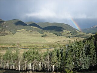
The San Luis Valley is a region in south-central Colorado with a small portion overlapping into New Mexico. The valley is approximately 122 miles (196 km) long and 74 miles (119 km) wide, extending from the Continental Divide on the northwest rim into New Mexico on the south. It contains 6 counties and portions of 3 others. It is an extensive high-elevation depositional basin of approximately 8,000 square miles (21,000 km2) with an average elevation of 7,664 feet (2,336 m) above sea level. The valley is a section of the Rio Grande Rift and is drained to the south by the Rio Grande, which rises in the San Juan Mountains to the west of the valley and flows south into New Mexico. The San Luis Valley has a cold desert climate but has substantial water resources from the Rio Grande and groundwater.

The Sangre de Cristo Range is a mountain range of the Rocky Mountains in southern Colorado in the United States, running north and south along the east side of the Rio Grande Rift. The mountains extend southeast from Poncha Pass for about 75 mi (121 km) through south-central Colorado to La Veta Pass, approximately 20 mi (32 km) west of Walsenburg, and form a high ridge separating the San Luis Valley on the west from the watershed of the Arkansas River on the east. The Sangre de Cristo Range rises over 7,000 ft (2,100 m) above the valleys and plains to the west and northeast.

Alamosa County is a county located in the U.S. state of Colorado. As of the 2020 census, the population was 16,376. The county seat is Alamosa. The county name is the Spanish language word for a "grove of cottonwood trees."

Great Sand Dunes National Park and Preserve is an American national park that conserves an area of large sand dunes up to 750 feet (230 m) tall on the eastern edge of the San Luis Valley, and an adjacent national preserve in the Sangre de Cristo Range, in south-central Colorado, United States. The park was originally designated Great Sand Dunes National Monument on March 17, 1932, by President Herbert Hoover. The original boundaries protected an area of 35,528 acres. A boundary change and redesignation as a national park and preserve was authorized on November 22, 2000, and then established on September 24, 2004. The park encompasses 107,342 acres while the preserve protects an additional 41,686 acres for a total of 149,028 acres. The recreational visitor total was 527,546 in 2019.

The Sangre de Cristo Mountains are the southernmost subrange of the Rocky Mountains. They are located in southern Colorado and northern New Mexico in the United States. The mountains run from Poncha Pass in South-Central Colorado, trending southeast and south, ending at Glorieta Pass, southeast of Santa Fe, New Mexico. The mountains contain a number of fourteen thousand foot peaks in the Colorado portion, as well as all the peaks in New Mexico which are over twelve thousand feet.
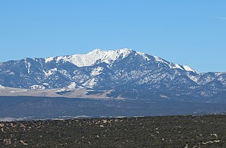
Blanca Peak is the fourth highest summit of the Rocky Mountains of North America and the U.S. state of Colorado. The ultra-prominent 14,351-foot (4,374 m) peak is the highest summit of the Sierra Blanca Massif, the Sangre de Cristo Range, and the Sangre de Cristo Mountains. The fourteener is located 9.6 miles (15.5 km) north by east of the Town of Blanca, on the drainage divide separating Rio Grande National Forest and Alamosa County from the Sangre de Cristo Land Grant and Costilla County. The summit is the highest point of both counties and the entire drainage basin of the Rio Grande. Below the steep North Face of Blanca Peak two live Glaciers once developed, until extinction sometime after 1903. North & South Blanca Glaciers were located at 37° 35N.,longitude 105° 28W. Blanca Peak is higher than any point in the United States east of its longitude.

The Alamosa National Wildlife Refuge is an 11,169-acre (4,520 ha) United States National Wildlife Refuge located in southern Colorado. The site is located in the San Luis Valley along the east side of the Rio Grande approximately 8 miles (13 km) southeast of Alamosa primarily in southeastern Alamosa County, although very small parts extend into northeastern Conejos and western Costilla counties. It is managed by the United States Fish and Wildlife Service jointly with the Baca and Monte Vista National Wildlife Refuges. It was established in 1962 as a haven for migratory birds and other wildlife.

Monte Vista National Wildlife Refuge is a United States National Wildlife Refuge located in southern Colorado. The refuge is located in the San Luis Valley south of the town of Monte Vista, Colorado in southeastern Rio Grande County, Colorado, in the watershed of the Rio Grande. It was established in 1953 by the Migratory Bird Conservation Commission to provide a habitat for wildlife, particularly waterfowl, in the San Luis Valley.

The Baca National Wildlife Refuge is a 78,697-acre (31,848 ha) United States National Wildlife Refuge located in southern Colorado. It is within the Sangre de Cristo National Heritage Area.

Rio Grande National Forest is a 1.86 million-acre (7,530 km²) U.S. National Forest located in southwestern Colorado. The forest encompasses the San Luis Valley, which is the world's largest agricultural alpine valley, as well as one of the world's largest high deserts located around mountains. The Rio Grande rises in the forest, and the Continental Divide runs along most of its western border. The forest lies in parts of nine counties. In descending order of land area within the forest they are Saguache, Mineral, Conejos, Rio Grande, Hinsdale, San Juan, Alamosa, Archuleta, and Custer counties. Forest headquarters are currently located in Monte Vista, Colorado, but plan to move to Del Norte. There are local ranger district offices in Del Norte, La Jara, and Saguache.
The Sangre de Cristo Wilderness is a long and narrow wilderness area covering 220,803 acres (893.56 km2) of the Sangre de Cristo Range centered about Saguache and Custer counties, Colorado. Smaller areas are located in Fremont, Alamosa, and Huerfano counties. The wilderness area is located on in the San Isabel and Rio Grande National Forests and Great Sand Dunes National Park and Preserve. The wilderness area is home to several fourteeners and quite a few thirteeners. Crestone Needle is considered the most difficult.

Zapata Falls is a waterfall located in the San Luis Valley near the base of the Sangre de Cristo Mountains on Bureau of Land Management land adjacent to Rio Grande National Forest and south of Great Sand Dunes National Park and Preserve in Alamosa County, Colorado. The waterfall has a drop of about 30 feet (9 m). Access to this waterfall entails a mildly steep 0.5-mile (800 m) hike. Viewing the falls requires fording the stream and climbing rocks.

La Veta Pass is the name associated with two nearby mountain passes in the Sangre de Cristo Mountains of south central Colorado in the United States, both lying on the boundary between Costilla and Huerfano counties.
The San Luis Valley Conservation Area is a proposed "landscape scale" National Conservation Area in south-central Colorado and far northern New Mexico which would be administered by the U.S. Fish and Wildlife Service:
The Closed Basin Project is a groundwater extraction project in the San Luis Valley in Colorado, United States, that began in the 1970s, and remains in operation in the 2020s. The project is managed by the United States Bureau of Reclamation.
Mount Zwischen is a prominent mountain summit in the Sangre de Cristo Range of the Rocky Mountains of North America. The 12,011-foot (3,661 m) peak is located 32.1 miles (51.6 km) northeast of the City of Alamosa, Colorado, United States, on the drainage divide separating the Great Sand Dunes Wilderness in Great Sand Dunes National Preserve and Huerfano County from the Sangre de Cristo Wilderness in San Isabel National Forest and Saguache County.

The San Luis Closed Basin is a 2,940-square-mile (7,600 km2) endorheic basin in the Alamosa and Saguache counties of south-central Colorado. It includes San Luis Creek and its tributary, Saguache Creek. While the basin is east of the majority of the Rocky Mountains, it lies west of the Sangre de Cristo Range. An elevated plateau in Alamosa County, the San Luis Hills, separates the San Luis Closed Basin drainage from most of the San Luis Valley, which is southward-flowing and drains through the Rio Grande.
Francisco Maestas et al. vs. George H. Shone et al. was a school desegregation case in Colorado involving Latino children in the early 20th Century. Filed in the Colorado district court, 12th district, in 1912 by Francisco Maestas against the Alamosa School District Superintendent and Board of Education in 1913, the case precedes Del Rio ISD v. Salvatierra by sixteen years, Alvarez v. Lemon Grove by seventeen years and Mendez v. Westminster by thirty-three years. The court ruled in favor of Maestas and the other Latino families.

The San Luis Hills are a group of small mountain ranges in Conejos and Costilla counties in the San Luis Valley in southern Colorado. The individual mountain ranges that make up the San Luis Hills include the Fairy Hills, the Brownie Hills, the Piñon Hills, and the South Piñon Hills. The San Luis Hills' highest point is Flat Top, elevation 9,206 feet
The Sangre de Cristo Land Grant in the San Luis Valley of southern Colorado and northern New Mexico consists of 1,000,000 acres (4,000 km2) of mostly arid land. It was awarded by the government of New Mexico to the Beaubien family in 1843. The land grant was originally settled by Hispanics from New Mexico. Since the incorporation of the area of the grant into the United States in 1848, legal disputes between the descendants of the Hispanic settlers and Anglo ranchers about ownership of and access to some of the land in the grant area have been frequent and continued into the 21st century.
