Lowry Pueblo

Last updated

Lowry Ruin
Lowry2.jpg
Lowry Pueblo
USA Colorado location map.svg
Red pog.svg
Usa edcp location map.svg
Red pog.svg
Location Montezuma County, Colorado, USA
Nearest city Pleasant View, Colorado
Coordinates 37°35′4.31″N108°55′10.73″W / 37.5845306°N 108.9196472°W / 37.5845306; -108.9196472
Area3 acres (1.2 ha)
NRHP reference No. 66000253
Significant dates
Added to NRHPOctober 15, 1966 [1]
Designated NHLJuly 19, 1964 [2]

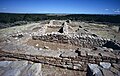
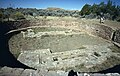
The Lowry Pueblo is an Ancestral Puebloan archaeological site located in Canyons of the Ancients National Monument near Pleasant View, Colorado, United States. The pueblo was constructed around 1060 AD atop abandoned pithouses from an earlier period of occupation. It was occupied by 40 to 100 people at a time for 165 years. [3] The site is one of the northernmost to be associated with the Puebloan cultures. [4] The site was declared a National Historic Landmark in 1964. [2] [4]

Contents

Description

Lowry Pueblo is located about 45 miles (72 km) northwest of Cortez, Colorado, and about 100 miles (160 km) north of Chaco Canyon, one of the major centers of Ancestral Puebloan culture. The pueblo was named for the early area homesteader George Lowry. It is believed to have begun as a relative small community with just a few rooms, but is unusual for the presence of a great kiva, suggesting it served as a communal center for a scattered population before the settlement around it got larger. [4] The inhabitants were farmers who also hunted small game, made elaborately decorated pottery, and wove cotton obtained by trade. Its last occupation occurred in the early 13th century.

Lowry Pueblo was first excavated during summer field seasons from 1930 to 1934 by Paul Sidney Martin of the Field Museum of Natural History in Chicago. [5] In 1965, the Bureau of Land Management (BLM), which owned the property, undertook a two-year project with the University of Colorado to stabilize the ruins, which had become partially buried. It was incorporated as part of the Canyons of the Ancients National Monument in 2000.

See also

Related Research Articles

<span class="mw-page-title-main">Cortez, Colorado</span> City in Colorado, United States

Cortez is a home rule municipality that is the county seat and the most populous municipality of Montezuma County, Colorado, United States. The city population was 8,766 at the 2020 United States Census.

<span class="mw-page-title-main">Mesa Verde National Park</span> U.S. national park in Colorado

Mesa Verde National Park is an American national park and UNESCO World Heritage Site located in Montezuma County, Colorado. The park protects some of the best-preserved Ancestral Puebloan archaeological sites in the United States.

The Pecos Classification is a chronological division of all known Ancestral Puebloans into periods based on changes in architecture, art, pottery, and cultural remains. The original classification dates back to consensus reached at a 1927 archæological conference held in Pecos, New Mexico, which was organized by the United States archaeologist Alfred V. Kidder.

<span class="mw-page-title-main">Bandelier National Monument</span> United States historic place

Bandelier National Monument is a 33,677-acre (13,629 ha) United States National Monument near Los Alamos in Sandoval and Los Alamos counties, New Mexico. The monument preserves the homes and territory of the Ancestral Puebloans of a later era in the Southwest. Most of the pueblo structures date to two eras, dating between 1150 and 1600 AD.

<span class="mw-page-title-main">Chaco Culture National Historical Park</span> U.S. national park in New Mexico

Chaco Culture National Historical Park is a United States National Historical Park in the American Southwest hosting a concentration of pueblos. The park is located in northwestern New Mexico, between Albuquerque and Farmington, in a remote canyon cut by the Chaco Wash. Containing the most sweeping collection of ancient ruins north of Mexico, the park preserves one of the most important pre-Columbian cultural and historical areas in the United States.

<span class="mw-page-title-main">Hovenweep National Monument</span> US national monument

Hovenweep National Monument is located on land in southwestern Colorado and southeastern Utah, between Cortez, Colorado and Blanding, Utah on the Cajon Mesa of the Great Sage Plain. Shallow tributaries run through the wide and deep canyons into the San Juan River.

<span class="mw-page-title-main">Navajo National Monument</span> National monument in Arizona, United States

Navajo National Monument is a National Monument located within the northwest portion of the Navajo Nation territory in northern Arizona, which was established to preserve three well-preserved cliff dwellings of the Ancestral Puebloan people: Keet Seel, Betatakin, and Inscription House. The monument is high on the Shonto plateau, overlooking the Tsegi Canyon system, west of Kayenta, Arizona. It features a visitor center with a museum, three short self-guided trails, two small campgrounds, and a picnic area.

<span class="mw-page-title-main">Yucca House National Monument</span> Archaeological site in Colorado, United States

Yucca House National Monument is a United States National Monument located in Montezuma County, Colorado between the towns of Towaoc and Cortez, Colorado. Yucca House is a large, unexcavated Ancestral Puebloan archaeological site.

<span class="mw-page-title-main">Hawkins Preserve</span> Conservation easement in Colorado

Hawkins Preserve is a 122-acre (0.49 km2) property within the city limits of Cortez, Colorado. It is protected by a conservation easement held by the Montezuma Land Conservancy.

<span class="mw-page-title-main">Canyons of the Ancients National Monument</span> Monument protecting significant sites of ancient Native Americans

Canyons of the Ancients National Monument is a national monument protecting an archaeologically significant landscape located in the southwestern region of the U.S. state of Colorado. The monument's 176,056 acres (71,247 ha) are managed by the Bureau of Land Management, as directed in the presidential proclamation which created the site on June 9, 2000. Canyons of the Ancients National Monument is part of the National Landscape Conservation System, better known as the National Conservation Lands. This system comprises 32 million acres managed by the Bureau of Land Management to conserve, protect, and restore these nationally significant landscapes recognized for their outstanding cultural, ecological, and scientific values. Canyons of the Ancients encompasses and surrounds three of the four separate sections of Hovenweep National Monument, which is administered by the National Park Service. The monument was proclaimed in order to preserve the largest concentration of archaeological sites in the United States, primarily Ancestral Puebloan ruins. As of 2022, over 8,500 individual archeological sites had been documented within the monument.

<span class="mw-page-title-main">Pleasant View, Colorado</span> Unincorporated community in Colorado, United States

Pleasant View is an unincorporated community and a U.S. Post Office located in Montezuma County, Colorado, United States. The Pleasant View Post Office has the ZIP Code 81331.

<span class="mw-page-title-main">Trail of the Ancients</span> National Scenic Byways in Arizona, Colorado, New Mexico, and Utah, United States

The Trail of the Ancients is a collection of National Scenic Byways located in the U.S. Four Corners states of Utah, Colorado, New Mexico, and Arizona. These byways comprise:

<span class="mw-page-title-main">Canyons of the Ancients Visitor Center and Museum</span> Archaeological museum in Dolores, Colorado

The Canyons of the Ancients Visitor Center and Museum located in Dolores, Colorado, is an archaeological museum of Native American pueblo and hunter-gatherer cultures. Two 12th-century archaeological sites, the Escalante and Dominguez Pueblos, at the center were once home to Ancient Pueblo peoples. The museum's permanent and special exhibits display some of the 3 million mostly Ancestral Puebloan artifacts curated at the facility. The center also houses a public research library, educational resources and a museum shop. Wheelchair-accessible facilities include a picnic area and an interpreted nature and cultural trail.

<span class="mw-page-title-main">Ancestral Puebloan dwellings</span> Ancestral Puebloan homes

Hundreds of Ancestral Puebloan dwellings are found across the American Southwest. With almost all constructed well before 1492 CE, these Puebloan towns and villages are located throughout the geography of the Southwest.

<span class="mw-page-title-main">Ansel Hall Ruin</span> Archaeological site in Colorado, United States

The Ansel Hall Ruin, also known as Cahone Ruin, is located in Cahone, Dolores County, Colorado. A pre-historic ruins from the Pueblo II period, the Northern San Juan pueblo was added to the National Register of Historic Places in 1997.

<span class="mw-page-title-main">Pueblo III Period</span> Era in the history of the Pueblo peoples

The Pueblo III Period was the third period, also called the "Great Pueblo period" when Ancestral Puebloans lived in large cliff-dwelling, multi-storied pueblo, or cliff-side talus house communities. By the end of the period, the ancient people of the Four Corners region migrated south into larger, centralized pueblos in central and southern Arizona and New Mexico.

<span class="mw-page-title-main">Pueblo IV Period</span> Era in the history of the Pueblo peoples

The Pueblo IV Period was the fourth period of ancient pueblo life in the American Southwest. At the end of prior Pueblo III Period, Ancestral Puebloans living in the Colorado and Utah regions abandoned their settlements and migrated south to the Pecos River and Rio Grande valleys. As a result, pueblos in those areas saw a significant increase in total population.

<span class="mw-page-title-main">Trail of the Ancients Scenic Byway (New Mexico)</span> Route in New Mexico with numerous archaeological and geological sites

The Trail of the Ancients is a New Mexico Scenic Byway to prehistoric archaeological and geological sites of northwestern New Mexico. It provides insight into the lives of the Ancestral Puebloans and the Navajo, Ute, and Apache peoples. Geological features include canyons, volcanic rock features, and sandstone buttes. Several of the sites are scenic and wilderness areas with recreational opportunities.

<span class="mw-page-title-main">Ancestral Puebloans</span> Ancient Native American culture in Four Corners region of the US

The Ancestral Puebloans, also known as the Anasazi, were an ancient Native American culture that spanned the present-day Four Corners region of the United States, comprising southeastern Utah, northeastern Arizona, northwestern New Mexico, and southwestern Colorado. They are believed to have developed, at least in part, from the Oshara tradition, which developed from the Picosa culture. The people and their archaeological culture are often referred to as Anasazi, meaning "ancient enemies", as they were called by Navajo. Contemporary Puebloans object to the use of this term, with some viewing it as derogatory.

References

  1. "National Register Information System". National Register of Historic Places . National Park Service. January 23, 2007.
  2. 1 2 "Lowry Ruin". National Historic Landmark summary listing. National Park Service. Archived from the original on January 4, 2008. Retrieved October 16, 2007.
  3. "Bureau of Land Management". Archived from the original on July 16, 2010. Retrieved April 16, 2012.
  4. 1 2 3 Albert H. Schroeder (September 24, 1962) National Survey of Historic Sites and Buildings: Lowry Pueblo (includes maps and diagrams of site), National Park Service and Accompanying 2 photos, from the Field expedition.
  5. "Field Museum News". September 1930. Retrieved May 6, 2020.

https://www.blm.gov/programs/national-conservation-lands/colorado/canyons-of-the-ancients