The Piccadilly line is a deep-level London Underground line running from the north to the west of London. It has two branches, which split at Acton Town, and serves 53 stations. The line serves Heathrow Airport, and some of its stations are near tourist attractions such as Piccadilly Circus and Buckingham Palace. The District and Metropolitan lines share some sections of track with the Piccadilly line. Printed in dark blue on the Tube map, it is the fourth busiest line on the Underground network, with over 210 million passenger journeys in 2011/12.

Southgate is a suburban area of North London, England in the London Borough of Enfield. It is located around 8 miles (13 km) north of Charing Cross. The name is derived from being the south gate to Enfield Chase.

Bounds Green is a London Underground station, located at the junction of Bounds Green Road and Brownlow Road in Bounds Green in the London Borough of Haringey, North London. The station is on the Piccadilly line, between Wood Green and Arnos Grove, and is on the boundary between Zone 3 and Zone 4.

Finsbury Park is an intermodal interchange station in north London. It serves a number of National Rail, London Underground and bus services. The station is the third busiest Underground station outside Zone 1, with over 33 million passengers using the station in 2019.

Cockfosters is a London Underground station on the Piccadilly line, for which it is the northern terminus. The station is located on Cockfosters Road (A111) approximately nine miles (14 km) from central London and serves Cockfosters. It is on the boundary of the London Borough of Barnet and the London Borough of Enfield. The station is in Travelcard Zone 5 and the next station towards Central London is Oakwood.

Barons Court is a London Underground station in West Kensington in the London Borough of Hammersmith and Fulham, Greater London. This station serves the District line and the Piccadilly line. Barons Court is between West Kensington and Hammersmith on the District line, and between Earl's Court and Hammersmith on the Piccadilly line and is in Travelcard Zone 2. East of the station, the Piccadilly line descends into tunnel towards Earl's Court and the District line continues in a cutting to West Kensington. The station is the last open air stop for eastbound trains on the Piccadilly line until Arnos Grove and has cross-platform interchange with the District line.

East Barnet is an area of north London within the London Borough of Barnet bordered by New Barnet, Cockfosters and Southgate. It is a largely residential suburb whose central area contains shops, public houses, restaurants and services, and the parish church of St Mary the Virgin. East Barnet is close to the M25 and the A1 and M1.

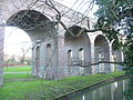
Arnos Grove is a London Underground station located in Arnos Grove in the London Borough of Enfield, London. It is on the Piccadilly line between Bounds Green and Southgate stations and is in Travelcard Zone 4. The station opened on 19 September 1932 as the most northerly station on the first section of the Piccadilly line extension from Finsbury Park to Cockfosters. It was the terminus of the line until services were further extended to Oakwood on 13 March 1933. When travelling from east of Barons Court and through Central London, Arnos Grove is the first surface station after the long tunnel section of the Piccadilly line. The station has four platforms which face three tracks.
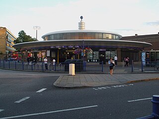
Southgate is a London Underground Piccadilly line station in Southgate. It is located between Arnos Grove and Oakwood stations and is in Travelcard Zone 4.

Oakwood is a London Underground station on the Piccadilly line. It is the second most northerly station on the line, between Southgate and Cockfosters stations, and is in Travelcard Zone 5. The station is on the edge of the Oakwood area of Enfield (N14) and is situated at the junction of Bramley Road (A110) and Chase Road. This station has step-free access after the upgrades made to the station between October and December 2007.

Wood Green is a London Underground station on the Piccadilly line. The station is between Turnpike Lane and Bounds Green stations and is in Travelcard Zone 3. It is located at junction of High Road, Wood Green and Lordship Lane. It serves Wood Green Shopping City and the nearby Haringey Council administrative complex as well as a densely populated residential area. It is also the closest tube station to Alexandra Palace.
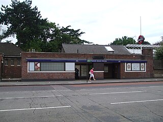
Manor House is a station on the Piccadilly line of the London Underground, on the boundary between Travelcard Zone 2 and Zone 3. It straddles the border between the London Boroughs of Hackney and Haringey, the postal address and three of the entrances being in the former, and one entrance in the latter.

Oakwood is an affluent suburban area of north London, in the London Borough of Enfield. It is situated within the Southgate postal area and was, historically, the southernmost area of Enfield Chase.

Osidge is a district in the London Borough of Barnet, between Brunswick Park and Southgate, just west of the border with the London Borough of Enfield. It may be loosely defined as the part of postal district N14 that is in Barnet. Osidge has no formal border and is entirely enclosed within the electoral ward of Brunswick Park, East Barnet; however Oak Hill Park forms a natural boundary to the North and Pymmes Brook to the West, with the A111 to the East and the Piccadilly line to the South/East.

New Southgate is a residential suburb straddling three Outer London Boroughs: a small part of the east of Barnet, a south-west corner of Enfield and in loosest definitions, based on nearest railway stations, a small northern corner of Haringey in North London, England where estates merge into Bounds Green.

The Edgware, Highgate and London Railway was a railway in North London. The railway was a precursor of parts of London Underground's Northern line and was, in the 1930s the core of an ambitious expansion plan for that line which was thwarted by the Second World War. Parts of the line were closed in the 1950s and have since been removed.

The London Borough of Enfield is the northernmost of the Outer London boroughs. The borough lies within the Metropolitan Green Belt, and several of its 123 or more parks and open spaces are part of it. The ancient Enfield Chase, remnants of which still exist, occupied much of the area. In addition to many playgrounds and sports facilities, the main areas of public open space are:

Brockley Hill was a proposed London Underground station in the Brockley Hill area of north London. The planned location is in what is now Edgware Way Grassland close to Edgwarebury Park on the north side of the junction of Edgware Way / Watford Bypass (A41), and Spur Road (A410).
Arnos Grove is an area of north London, England, within the London Borough of Enfield. It is centred 7.5 miles (12 km) north of Charing Cross. It is adjacent to New Southgate. The natural grove, larger than today, was for many centuries the largest woodland in the chapelry of Southgate in the parish of Edmonton. It became inter-related with Arnos Park when its owner was permitted to enclose much of its area through the widespread legal practice of inclosure of the common land to create the former park, the heart of which is now public parkland.

The Great Northern, Piccadilly and Brompton Railway (GNP&BR), also known as the Piccadilly tube, was a railway company established in 1902 that constructed a deep-level underground "tube" railway in London. The GNP&BR was formed through a merger of two older companies, the Brompton and Piccadilly Circus Railway (B&PCR) and the Great Northern and Strand Railway (GN&SR). It also incorporated part of a tube route planned by a third company, the District Railway (DR). The combined company was a subsidiary of the Underground Electric Railways Company of London (UERL).