College Park is a city in Prince George's County, Maryland, United States, located approximately four miles (6.4 km) from the northeast border of Washington, D.C. Its population was 34,740 at the 2020 United States census. It is the home of the University of Maryland, College Park.
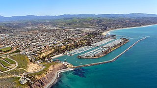
Dana Point is a city located in southern Orange County, California, United States. The population was 33,107 at the 2020 census. It has one of the few harbors along the Orange County coast, and with ready access via State Route 1, it is a popular local destination for surfing.

Laguna Niguel is a city in Orange County, California, United States. The name Laguna Niguel is derived from the words "Laguna" and "Niguili". As of the 2020 census, the population was 64,355. Laguna Niguel is located in the San Joaquin Hills in the southeastern corner of Orange County, close to the Pacific Ocean, and borders the cities of Aliso Viejo, Dana Point, Laguna Beach, Laguna Hills, Mission Viejo, and San Juan Capistrano.

San Clemente is a city in Orange County, California, United States. Located in the Orange Coast region of the South Coast of California, San Clemente's population was 64,293 in at the 2020 census. Situated roughly midway between Los Angeles and San Diego, San Clemente is a popular tourist destination in Southern California, known for its beaches, Spanish Colonial Revival architecture, and hospitality industry. San Clemente's city slogan is "Spanish Village by the Sea".
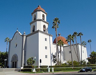
San Juan Capistrano is a city in southern Orange County, California, United States. The population was 35,253 at the 2020 Census.

The Arroyo Seco, meaning "dry stream" in Spanish, is a 24.9-mile-long (40.1 km) seasonal river, canyon, watershed, and cultural area in Los Angeles County, California. The area was explored by Gaspar de Portolà who named the stream Arroyo Seco as this canyon had the least water of any he had seen. During this exploration he met the Chief Hahamog-na (Hahamonga) of the Tongva Indians.
City Heights is a dense urban community in central San Diego, California, known for its ethnic diversity. The area was previously known as East San Diego. City Heights is located south of Mission Valley and northeast of Balboa Park.

A nest box, also spelled nestbox, is a man-made enclosure provided for animals to nest in. Nest boxes are most frequently utilized for birds, in which case they are also called birdhouses or a birdbox/bird box, but some mammals such as bats may also use them. Placing nestboxes or roosting boxes may also be used to help maintain populations of particular species in an area.

San Antonio Missions National Historical Park is a National Historical Park and part of a UNESCO World Heritage Site preserving four of the five Spanish frontier missions in San Antonio, Texas, USA. These outposts were established by Catholic religious orders to spread Christianity among the local natives. These missions formed part of a colonization system that stretched across the Spanish Southwest in the 17th, 18th, and 19th centuries.
California's 49th congressional district is a congressional district in the U.S. state of California. The district is represented by Mike Levin.

Stevens Creek is a 20.9-mile-long (33.6 km) stream in Santa Clara County, California. The creek originates in the Santa Cruz Mountains on the western flank of Black Mountain in the Monte Bello Open Space Preserve near the terminus of Page Mill Road at Skyline Boulevard. It flows southeasterly through the Stevens Creek County Park before turning northeast into Stevens Creek Reservoir. It then continues north for 12.5 miles (20.1 km) through Cupertino, Los Altos, Sunnyvale and Mountain View before emptying into the San Francisco Bay at the Whisman Slough, near Google's main campus.

Cypress Park is a densely populated neighborhood of 10,000+ residents in Northeast Los Angeles, California. Surrounded by hills on three sides, it sits in the valley created by the Los Angeles River and the Arroyo Seco. It is the site of the Rio de Los Angeles State Park, the Los Angeles River Bike Path and other recreational facilities. It hosts one private and four public schools.

The Acjachemen are an Indigenous people of California. Published maps often identify their ancestral lands as extending from the beach to the mountains, south from what is now known as Aliso Creek in Orange County to the Las Pulgas Canyon in the northwestern part of San Diego County. However, sources also show that Acjachemen people shared sites with other indigenous nations as far north as Puvunga in contemporary Long Beach.
San Juan Capistrano station is a train station in San Juan Capistrano, California, United States served by Amtrak, the national railroad passenger system, and Metrolink, a commuter railroad. The station has a single side platform serving the single track of the SCRRA's Orange Subdivision.

San Juan Creek, also called the San Juan River, is a 29-mile (47 km) long stream in Orange and Riverside Counties, draining a watershed of 133.9 square miles (347 km2). Its mainstem begins in the southern Santa Ana Mountains in the Cleveland National Forest. It winds west and south through San Juan Canyon, and is joined by Arroyo Trabuco as it passes through San Juan Capistrano. It flows into the Pacific Ocean at Doheny State Beach. State Route 74, the Ortega Highway, crosses the Santa Ana Mountains via San Juan Canyon.

Arroyo Trabuco is a 22-mile (35 km)-long stream in coastal southern California in the United States. Rising in a rugged canyon in the Santa Ana Mountains of Orange County, the creek flows west and southwest before emptying into San Juan Creek in the city of San Juan Capistrano. Arroyo Trabuco's watershed drains 54 square miles (140 km2) of hilly, semi-arid land and lies mostly in Orange County, with a small portion extending northward into Riverside County. The lower section of the creek flows through three incorporated cities and is moderately polluted by urban and agricultural runoff.

Aliso and Wood Canyons Wilderness Park is a major regional park in the San Joaquin Hills of Orange County, California in the United States. Comprising 4,500 acres (1,800 ha) of rugged coastal canyons, open grassland, and riparian woodland, the park borders the suburban cities of Aliso Viejo, Dana Point, Laguna Beach, Laguna Hills and Laguna Niguel and lies within a portion of the ancestral homeland of the indigenous Acjachemen people.

Salt Creek is a small coastal stream in southern Orange County, California in the United States. About 4 miles (6.4 km) long, the creek drains 6.1 square miles (16 km2) in parts of the cities of Laguna Niguel and Dana Point. The creek begins in Laguna Niguel and flows west and south through a narrow canyon, partly in the Salt Corridor Regional Park. It empties into the Pacific Ocean at Salt Creek County Beach in Dana Point.

Sulphur Creek is an approximately 4.5-mile (7.2 km) tributary of Aliso Creek in Orange County, California. The creek drains about 6 square miles (16 km2) in the suburban cities of Laguna Niguel and Laguna Hills. Although most of its watershed has been utilized for master planned residential development, the creek retains a natural channel with riparian and wetland habitat in parts of Laguna Niguel Regional Park and Aliso and Wood Canyons Regional Park. Urban runoff has changed the once seasonal creek into a perennial stream.

The Hayward Area Recreation and Park District (H.A.R.D.) is the park management agency for most of the parks in the city of Hayward, California. It was created in 1944 and is an independent special district under California law. H.A.R.D. is the largest recreation district in California. It also manages parks in the bordering unincorporated communities of Castro Valley, San Lorenzo, Fairview, Ashland and Cherryland. It manages the park grounds for numerous schools in the region. Events and classes are scheduled and listed in a quarterly brochure. The parks' 2021 budget is $24,306,495.


