
The 5th street bridge, also known as the Arthur J. DiTommaso Memorial Bridge, [1] is a cable stayed bridge in Fitchburg, Massachusetts. It crosses the North Nashua River and the Fitchburg Line of the MBTA Commuter Rail.
The 5th street bridge, also known as the Arthur J. DiTommaso Memorial Bridge, [1] is a cable stayed bridge in Fitchburg, Massachusetts. It crosses the North Nashua River and the Fitchburg Line of the MBTA Commuter Rail.

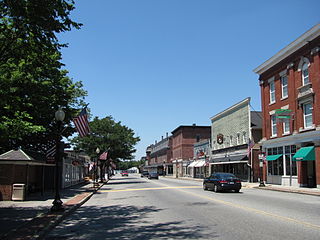
Fitchburg is a city in northern Worcester County, Massachusetts, United States. The third-largest city in the county, its population was 41,946 at the 2020 census. Fitchburg is home to Fitchburg State University as well as 17 public and private elementary and high schools.

Nashua is a city in southern New Hampshire, United States. As of the 2020 census, it had a population of 91,322, the second-largest in northern New England after nearby Manchester. Along with Manchester, it is a seat of New Hampshire's most populous county, Hillsborough.

North Station is a commuter rail and intercity rail terminal station in Boston, Massachusetts. It is served by four MBTA Commuter Rail lines – the Fitchburg Line, Haverhill Line, Lowell Line, and Newburyport/Rockport Line – and the Amtrak Downeaster intercity service. The concourse is located under the TD Garden arena, with the platforms extending north towards drawbridges over the Charles River. The eponymous subway station, served by the Green Line and Orange Line, is connected to the concourse with an underground passageway.
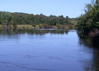
The Nashua River, 37.5 miles (60.4 km) long, is a tributary of the Merrimack River in Massachusetts and New Hampshire in the United States. It is formed in eastern Worcester County, Massachusetts, at the confluence of the North Nashua River and South Nashua River, and flows generally north-northeast past Groton to join the Merrimack at Nashua, New Hampshire. The Nashua River watershed occupies a major portion of north-central Massachusetts and a much smaller portion of southern New Hampshire.

The Fitchburg Railroad is a former railroad company, which built a railroad line across northern Massachusetts, United States, leading to and through the Hoosac Tunnel. The Fitchburg was leased to the Boston and Maine Railroad in 1900. The main line from Boston to Fitchburg is now operated as the MBTA Fitchburg Line; Pan Am Railways runs freight service on some other portions.
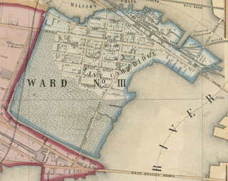
East Cambridge is a neighborhood of Cambridge, Massachusetts. Referred to in modern times as Area 1, East Cambridge is bounded by the Charles River and the Charlestown neighborhood of Boston on the east, the Somerville border on the north, Broadway and Main Street on the south, and the railroad tracks on the west. Most of the streets form a grid aligned with Cambridge Street, which was laid out to directly connect what is now the Charles River Dam Bridge with what in 1809 was the heart of Cambridge, Harvard Square. The northern part of the grid is a roughly six by eight block residential area. Cambridge Street itself is retail commercial, along with Monsignor O'Brien Highway, the Twin Cities Plaza strip mall, and the enclosed Cambridgeside Galleria. Lechmere Square is the transportation hub for the northern side. The southern half of the grid is largely office and laboratory space for hundreds of dot-com companies, research labs and startups associated with MIT, biotechnology firms including Genzyme, Biogen and Moderna, the Athenaeum Press Building, light industry, an NRG Energy power station, and various small businesses. This half of the neighborhood is generally identified with Kendall Square. Along the waterfront are several hotels and taller apartment buildings.
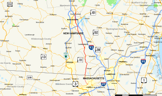
Mammoth Road is a north–south road in Massachusetts and New Hampshire. The road runs from its origin in Lowell, Massachusetts to its northern end in Hooksett, New Hampshire, a suburb of Manchester. The total length of the road is 29.3 miles (47.2 km). It was named "Mammoth" in the hope that the convenience of its directness and elimination of smaller connecting roads between thoroughfares would result in sufficient use and prestige as to "kill all the other roads."

The Charles River Esplanade of Boston, Massachusetts, is a state-owned park situated in the Back Bay area of the city, on the south bank of the Charles River Basin.
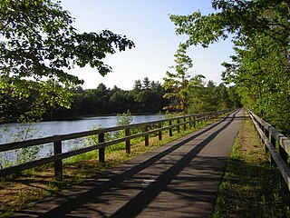
The Nashua River Rail Trail is a 12.5-mile (20.1 km) paved mixed-use rail trail in northern Massachusetts and southern New Hampshire under control of the Massachusetts Department of Conservation and Recreation (DCR). It roughly follows the course of the Nashua River, passing through the towns of Ayer, Groton, Pepperell, and Dunstable, Massachusetts and ends about a mile across the New Hampshire state border in Nashua, New Hampshire. The trail is used by walkers, cyclists, inline skaters, equestrians, and cross-country skiers.

The Circumferential Highway is the common name for a bypass route around the city of Nashua in southern New Hampshire, most of which has not yet been built. The purpose of the highway is to provide easier access to the F.E. Everett Turnpike and U.S. Route 3 in Nashua. Most of the highway is planned to be built in Hudson, with small sections also built through the towns of Litchfield and Merrimack as well as the city of Nashua.
North Point is a neighborhood within the East Cambridge section of Cambridge, Massachusetts. A former railroad yard, the site was originally built by the Boston and Maine Railroad. It is triangular in shape and bound by Pan Am Systems, the Charles River and associated dam with the Lechmere Viaduct, the former Lechmere wetlands and Millers River remnant that once divided Cambridge and Charlestown, along with the Interstate 93 Northern Expressway viaduct to the northeast.

North Leominster is a village or neighborhood of the city of Leominster, Massachusetts. Settlement started in 1725, and by 1740 Leominster was separated from the town of Lancaster, Massachusetts. Settlers north of North Nashua River were in the North village. The name changed over time from North Village to North Leominster.

Ayer station is an MBTA Commuter Rail station located off Main Street in the Ayer Main Street Historic District of Ayer, Massachusetts. It serves the Fitchburg Line. There are three tracks through the station, two of which are served by a pair of low-level side platforms, which are not accessible. There is a shelter on the inbound platform.

North Point Park is an 8.5-acre (3.4 ha) park located along the north side of the Charles River in Cambridge, Massachusetts and Boston's West End, created as mitigation for the taking of planned parkland for the construction of the Big Dig.
Cambridge Highlands also known as "Area 12", is a neighborhood of Cambridge, Massachusetts bounded by the railroad tracks on the north and east, the Belmont town line on the west, and Fresh Pond on the south. In 2005 it had a population of 673 residents living in 281 households, and the average household income was $56,500.
Ayer is a town in Middlesex County, Massachusetts, United States. Originally part of Groton, it was incorporated February 14, 1871, and became a major commercial railroad junction. The town was home to Camp Stevens, a training camp for Massachusetts volunteers during the American Civil War. Later, Fort Devens was established by the federal government to train New England soldiers for World War I. Fort Devens is a major influence on the area, although it is considerably smaller than when it was first closed in the mid-1990s. The town's population was 8,479 at the 2020 census.
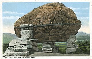
The Rollstone Boulder is a ten-foot-tall, 110-ton porphyritic granite glacial erratic located on a traffic island in downtown Fitchburg, Massachusetts. The boulder was exploded at its original location at the summit of Rollstone Hill and then reassembled near Fitchburg's Upper Common in 1929 from the pieces.

The South Nashua River is a river in Massachusetts that flows 5.1 miles (8.2 km) through Clinton and Lancaster. It starts at the Wachusett Dam on the Wachusett Reservoir and ends by joining the North Nashua River to form the Nashua River.
The Whitman River is an 8.4-mile-long (13.5 km) river in Massachusetts that flows through Ashburnham, Westminster and Fitchburg. It arises from Lake Wampanoag in Ashburnham, travels through a couple of ponds in Westminster, and ultimately joins Phillips Brook in Fitchburg to form the North Nashua River.

Phillips Brook is an 8-mile-long (13 km) river in Massachusetts that flows through Ashburnham, Westminster, and Fitchburg. The river rises from Lake Winnikeag in Ashburnham, flows through Westminster, and meets the Whitman River in Fitchburg to form the North Nashua River.
Coordinates: 42°34′32″N71°47′16″W / 42.5755°N 71.7878°W
| | This article about a bridge in Massachusetts is a stub. You can help Wikipedia by expanding it. |