
Lake Winnebago is a shallow freshwater lake in the north central United States, located in east central Wisconsin. At 137,700 acres it is the largest lake entirely within the state, covering an area of about 30 miles by 10 miles, with 88 miles of shoreline, an average depth of 15.5 feet, and a maximum depth of 21 feet. It has many shallow reefs along the west shore, and a drop-off type shoreline on the east. There are several islands along the west shore.

Cazenovia Lake is a lake in Madison County, New York. It is located 20 miles (32 km) southeast of the city of Syracuse. The village of Cazenovia is located southeast of the lake.
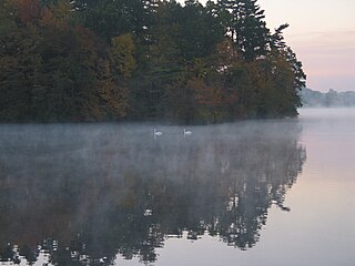
Lake Attitash is a lake located on the border of Merrimac, Massachusetts and Amesbury, Massachusetts, and constitutes at least a portion of Amesbury's water supply.
Lake Winnisquam is in Belknap County in the Lakes Region of central New Hampshire, United States, in the communities of Meredith, Laconia, Sanbornton, Belmont, and Tilton. At 4,214 acres (1,705 ha), it is the fourth-largest lake entirely in New Hampshire. The lake is roughly triangular in shape, with the vertexes pointing north, east, and south. The lake lies along the path of the Winnipesaukee River, which enters the lake from its eastern corner and carries water from Lake Winnipesaukee via Paugus Bay and Opechee Bay. The river also flows south out of Winnisquam's southern corner, eventually joining the Merrimack River. The lake extends several miles north from the course of the Winnipesaukee River, which forms the lake's southeastern side, with the northern point being formed by the confluence of several smaller creeks near the village of Meredith Center. The lake has a maximum depth of 155 feet (47 m).
Cayuta Lake is a small lake located in Schuyler County, New York, United States. It is within the Town of Catharine, about three miles (4.8 km) north of Odessa. The lake is also referred to locally as Little Lake.
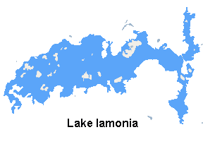
Lake Iamonia ⟨aɪ ˈmoʊ njə⟩ is a large, subtropical prairie lake in northern Leon County, Florida, United States, created during the Pleistocene epoch.

Highland Lake is a 697-acre (2.82 km2) water body located in Sullivan and Cheshire counties in southwestern New Hampshire, United States, in the towns of Washington and Stoddard. The lake has two outlets. The north outlet feeds Shedd Brook, while the south outlet flows through Island Pond to the North Branch of the Contoocook River. Water from the two outlets rejoins in the town of Hillsborough, approximately 8 miles (13 km) east of Highland Lake and one mile upstream from the Contoocook River. The northern end of the lake is only accessible by boat through a channel approximately 50 feet wide.
Lamoka Lake, previously known as Mud Lake, is a small crescent-shaped lake in the western part of New York state. The lake is located at the border of Schuyler County and Steuben County. Most of the lake is in Schuyler County with only a small part, called "Mill Pond," at the southwest corner in Steuben County.

Browning Pond is located in Oakham and Spencer, Massachusetts. This 89-acre (360,000 m2) great pond forms the headwaters of the Seven Mile River. It is part of the Chicopee River Watershed.

Billington Sea is a 269-acre (1.09 km2) warm water pond located in Plymouth, Massachusetts. Morton Park lies on the pond's northern shore. The pond is fed by groundwater and cranberry bog outlets. The average depth is seven feet and the maximum depth is 11 feet (3.4 m). The pond provides the headwaters to Town Brook. Seymour Island is located in the center of the pond. Billington Sea was named after its discoverer, Francis Billington, one of the passengers on the Mayflower.
Bear Island Lake is a lake which is about 15 miles (24 km) southwest of Ely in the U.S. state of Minnesota. The lake measures 2,351 acres (9.51 km2), or about 2 miles (3.2 km) by 4 miles (6.4 km). There are at least 20 other islands in the lake. The shoreline of the natural glacial lake is about two-thirds state and national forest, including Bear Island State Forest. While deep in parts, several shallow bays and natural sand beaches make it a popular swimming spot.

Winnecunnet Pond or Winneconnet Pond or Winnecunnett Pond, very often called Lake Winnecunnet or Lake Winneconnet or Lake Winnecunnett although it is a pond rather than a lake, is a body of water in Norton, Massachusetts, United States.
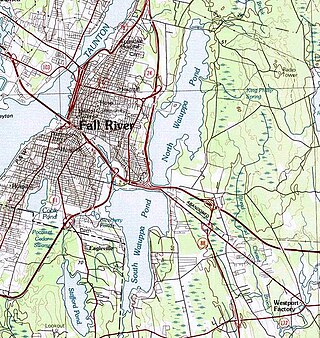
The Watuppa Ponds are two large, naturally occurring, spring-fed, glacially formed ponds located in Fall River and Westport, Massachusetts. Watuppa is a native word meaning "place of boats". The two ponds were originally one body of water, connected by a narrow rocky straight called "The Narrows" located on a thin strip of land between the two ponds which forms part boundary of between Fall River and Westport. The border between Fall River and Westport is also divided between the two ponds. Together, the ponds have an overall north–south length of about 7.5 miles, and have an average east–west width of about a mile. The ponds are drained by the Quequechan River, and flows in a westerly direction through the center of Fall River from South Watuppa Pond to Mount Hope Bay.

Lake Ronkonkoma is a freshwater lake in Suffolk County, New York. It is a kettle lake formed by retreating glaciers and is the largest freshwater lake on Long Island; it has a circumference of about 2 miles (3.2 km) and is 0.65 miles (1.05 km) across on average. The lake is owned by the Town of Islip under the terms of the Nichols Patent. The land around it is controlled by three town governments – Smithtown, Islip and Brookhaven. The separation originated because three different Native American communities claimed lands on different shores, and these claims continued when the tribes gave separate deeds to the land under their control. The name Ronkonkoma comes from an Algonquian expression meaning "boundary fishing-lake", also earlier written as Raconkumake and Raconkamuck.
Druid Lake is a kettle lake located in the town of Erin, Wisconsin, Washington County, Wisconsin near Hartford, Wisconsin. Druid Lake is a natural glacial-formed lake. Druid Lake is surrounded by rugged mixed woods and glacial drumlins in the Southern Savannah Region of southeastern Wisconsin's Kettle Moraine area about 25 miles northwest of Milwaukee. The lake has a maximum depth of 53 feet (16 m). The lake covers 120.9 acres (0 km2), has 2.3 miles (3.7 km) of shoreline and has an average depth of 25 feet (10 m).

Mashapaug Lake is a 297-acre (1.20 km2) lake surrounded by Bigelow Hollow State Park and Nipmuck State Forest in the town of Union in northeastern Connecticut. The lake has a maximum depth of 39.5 feet, and an average depth of 15 feet. Its normal surface elevation is 706 feet. The lake is very popular with fishermen and boaters from the area, and can also be used for swimming.
Lake Chaffee is a small, shallow, man-made lake located approximately 2 miles (3.2 km) northwest of the hamlet of Westford in the town of Ashford in Windham County, northeastern Connecticut. The lake has an area of 54 acres (22 ha) and a maximum depth of 11 feet (3.4 m). Its average surface elevation is 856 feet (261 m) above sea level.
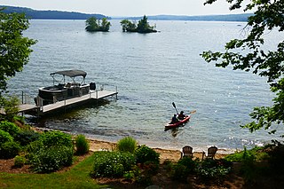
Lovewell Pond is a sizable body of water located in southeastern Fryeburg, Maine. It has a moderately developed shoreline with approximately 75-80 buildings, not including approximately 35 others with access rights to the pond's shoreline.
China Lake is a lake in Kennebec County, Maine. Located northeast of the state capital of Augusta, China Lake is situated in the towns of China and Vassalboro. China Lake has two large basins connected by a narrow neck. The elongated eastern basin with an average depth of less than 30 feet (9.1 m) is entirely within the town of China, and has an irregular shoreline heavily developed with residences and seasonal cottages. The more nearly circular western basin extending into East Vassalboro is as deep as 85 feet (26 m), and shoreline development around the western basin has been discouraged to allow use as a water supply for Waterville and Winslow. The western basin overflows into Outlet Stream in the town of Vassalboro. Outlet Stream flows 7 miles (11 km) north to discharge into the Sebasticook River in Winslow 1 mile (1.6 km) upstream of the Kennebec River.
Lake Moraine is a mesotrophic lake located 2.5 miles (4.0 km) northeast of Hamilton, New York. The lake is 261 acres (1.06 km2), consisting of two basins which are separated by a causeway and interconnected by a culvert. The northern basin is 79 acres (0.32 km2) and is relatively shallow with a maximum depth of 12 feet (3.7 m) and average depth of 3.7 feet (1.1 m). The larger southern basin is 172 acres (0.70 km2) and has a maximum depth of 45 feet (14 m) and an average depth of 17.7 feet (5.4 m). Payne Brook is the lake's outflow that flows into the Chenango River.


