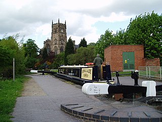
The Staffordshire and Worcestershire Canal is a navigable narrow canal in Staffordshire and Worcestershire in the English Midlands. It is 46 miles (74 km) long, linking the River Severn at Stourport in Worcestershire with the Trent and Mersey Canal at Haywood Junction by Great Haywood.

The Stour(, rhymes with "flour") is a river flowing through the counties of Worcestershire, the West Midlands and Staffordshire in the West Midlands region of England. The Stour is a major tributary of the River Severn, and it is about 25 miles (40 km) in length. It has played a considerable part in the economic history of the region.
Penkridge is a large village and civil parish in South Staffordshire District in Staffordshire, England. It is to the south of Stafford, north of Wolverhampton, west of Cannock and east of Telford.

Kingswinford is a town of the Metropolitan Borough of Dudley in the English West Midlands, situated 5 miles (8.0 km) west-southwest of central Dudley. In 2011 the area had a population of 25,191, down from 25,808 at the 2001 Census.

Wombourne is a large village and civil parish located in the district of South Staffordshire, in the county of Staffordshire, England. It is 4 miles (6 km) south-west of Wolverhampton and just outside the county and conurbation of the West Midlands.

Brewood is an ancient market town in the civil parish of Brewood and Coven, in the South Staffordshire district, in the county of Staffordshire, England. Located around grid reference SJ883088, Brewood lies near the River Penk, eight miles north of Wolverhampton city centre and eleven miles south of the county town of Stafford. A few miles to the west of Brewood is the border with the county of Shropshire.
Kinver is a large village in the District of South Staffordshire in Staffordshire, England. It is in the far south-west of the county, at the end of the narrow finger of land surrounded by the counties of Shropshire, Worcestershire and the West Midlands. The nearest towns are Stourbridge, West Midlands, Kidderminster in Worcestershire and Bridgnorth, Shropshire. The Staffordshire and Worcestershire Canal passes through, running close to the course of the meandering River Stour. According to the 2011 census Kinver ward had a population of 7,225.
Wordsley is a suburban area of Stourbridge in the West Midlands, England. It is part of the Metropolitan Borough of Dudley and falls into the Stourbridge (DY8) postcode and address area, being just north of the River Stour. Wordsley is part of the Dudley South Parliamentary constituency. It is bordered by open countryside to the west, Kingswinford to the North, Brierley Hill to the East and Stourbridge to the South.
Kingswinford Rural District was a rural district in Staffordshire, England from 1894 to 1934. It was created by the Local Government Act 1894, and originally consisted of the two parishes of Amblecote and Kingswinford. Amblecote became a separate urban district in 1898, leaving Kingswinford the only parish in the district.
Wall Heath is a suburban village in the Dudley Metropolitan Borough in the West Midlands of England. It is located on the A449 road, approximately 1.5 miles northwest of Kingswinford, 5 miles west of Dudley Town Centre and 9 miles north of Kidderminster. It forms part of the West Midlands-South Staffordshire border.

Cookley is a village in the Wyre Forest District of Worcestershire, England, a few miles to the north of Kidderminster. Also, a few miles south-west of Stourton, Staffordshire and is close to the villages of Kinver and Wolverley. It lies on the River Stour, and the Staffordshire and Worcestershire Canal in the civil parish of Wolverley and Cookley. At the time of the 2001 census had a population of 2,491.
Stourton is a hamlet in Staffordshire, England a few miles to the northwest of Stourbridge. There is a fair amount of dispute over the pronunciation, being pronounced 'stower-ton', 'stir-ton' or 'store-ton' by different people from the area. The nearest sizeable villages are Wollaston and Kinver, the nearest hamlets are Prestwood and Dunsley. It lies on the River Stour. The Staffordshire and Worcestershire Canal and Stourbridge Canal meet at Stourton Junction, which places Stourton on the Stourport Ring, a navigable waterway popular with narrowboat holidaymakers.

Rushall is a suburb in the Metropolitan Borough of Walsall in the West Midlands, England. It is centred on the main road between Walsall and Lichfield. It is mentioned in the Domesday Book but has mostly developed since the 1920s. Rushall was historically a part of the county of Staffordshire before it was incorporated with much of the old Aldridge-Brownhills Urban District into the modern-day Walsall district.
Swindon is a village and civil parish located in the West Midlands. The nearest major town is Dudley, approximately five miles eastwards. It stands halfway between the small town of Kingswinford and village of Wombourne.
The Smestow Brook, sometimes called the River Smestow, is a small river that plays an important part in the drainage of Wolverhampton, South Staffordshire, and parts of Dudley in the United Kingdom, and has contributed to the industrial development of the Black Country. It is the most important tributary of the River Stour, Worcestershire and part of the River Severn catchment.

Greensforge is a scattered hamlet on the boundary of Kinver and Swindon parishes, in South Staffordshire, England. It is noted for its Roman associations and its industrial heritage.

Highgate Common is a Staffordshire Wildlife Trust reserve containing a mix of heathland and woodland. It is about 129 hectares or 320 acres in size. The common is a popular leisure destination and a Site of Special Scientific Interest, located in Southern Staffordshire, England.
Prestwood is a hamlet now in the parish of Kinver, but in the Kingswinford until the creation of Brierley Hill Urban District in the 1930s.
Kinver Forest was a Royal Forest, mainly in Staffordshire.
Iverley is an area of the parish of Kinver in Staffordshire that has no road link to the rest of the parish. It is notable as being the most southerly point in Staffordshire.

