Related Research Articles

Worcestershire is a ceremonial county in the West Midlands of England. It is bordered by Shropshire, Staffordshire, and the West Midlands county to the north, Warwickshire to the east, Gloucestershire to the south, and Herefordshire to the west. The city of Worcester is the largest settlement and the county town.
The Staffordshire and Worcestershire Canal is a navigable narrow canal in Staffordshire and Worcestershire in the English Midlands. It is 46 miles (74 km) long, linking the River Severn at Stourport in Worcestershire with the Trent and Mersey Canal at Haywood Junction by Great Haywood.

The Stour(, rhymes with "flour") is a river flowing through the counties of Worcestershire, the West Midlands and Staffordshire in the West Midlands region of England. The Stour is a major tributary of the River Severn, and it is about 25 miles (40 km) in length. It has played a considerable part in the economic history of the region.
Edward Sutton, 5th Baron Dudley was an English peer, politician and landowner who briefly sat in the House of Commons. Through his intemperate behaviour he won widespread notoriety, completed the financial ruin of his family, and was the last of his name to bear the title.

Ashwood is a small area of Staffordshire, England.
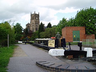
Kinver is a large village in the District of South Staffordshire in Staffordshire, England. It is in the far south-west of the county, at the end of the narrow finger of land surrounded by the counties of Shropshire, Worcestershire and the West Midlands. The nearest towns are Stourbridge, West Midlands, Kidderminster in Worcestershire and Bridgnorth, Shropshire. The Staffordshire and Worcestershire Canal passes through, running close to the course of the meandering River Stour. According to the 2011 census Kinver ward had a population of 7,225.

Cookley is a village in the Wyre Forest District of Worcestershire, England, a few miles to the north of Kidderminster. Also, a few miles south-west of Stourton, Staffordshire and is close to the villages of Kinver and Wolverley. It lies on the River Stour, and the Staffordshire and Worcestershire Canal in the civil parish of Wolverley and Cookley. At the time of the 2001 census had a population of 2,491.
Stourton is a hamlet in Staffordshire, England a few miles to the northwest of Stourbridge. There is a fair amount of dispute over the pronunciation, being pronounced 'stower-ton', 'stir-ton' or 'store-ton' by different people from the area. The nearest sizeable villages are Wollaston and Kinver, the nearest hamlets are Prestwood and Dunsley. It lies on the River Stour. The Staffordshire and Worcestershire Canal and Stourbridge Canal meet at Stourton Junction, which places Stourton on the Stourport Ring, a navigable waterway popular with narrowboat holidaymakers.
Swindon is a village and civil parish located in the West Midlands. The nearest major town is Dudley, approximately five miles eastwards. It stands halfway between the small town of Kingswinford and village of Wombourne.

Blakeshall is a hamlet in Worcestershire, England. It is one of the ancient townships of the manor of Wolverley, whose extent was similar to that of the modern civil parish of Wolverley & Cookley.
The Smestow Brook, sometimes called the River Smestow, is a small river that plays an important part in the drainage of Wolverhampton, South Staffordshire, and parts of Dudley in the United Kingdom, and has contributed to the industrial development of the Black Country. It is the most important tributary of the River Stour, Worcestershire and part of the River Severn catchment.

Greensforge is a scattered hamlet on the boundary of Kinver and Swindon parishes, in South Staffordshire, England. It is noted for its Roman associations and its industrial heritage.
Morfe Forest was a medieval royal forest in east Shropshire.

Feckenham Forest was a royal forest, centred on the village of Feckenham, covering large parts of Worcestershire and west Warwickshire. It was not entirely wooded, nor entirely the property of the King. Rather, the King had legal rights over game, wood and grazing within the forest, and special courts imposed harsh penalties when these rights were violated. Courts and the forest gaol were located at Feckenham and executions took place at Gallows Green near Hanbury.

Penkridge is a village and parish in Staffordshire with a history stretching back to the Anglo-Saxon period. A religious as well as a commercial centre, it was originally centred on the Collegiate Church of St. Michael and All Angels, a chapel royal and royal peculiar that maintained its independence until the Reformation. Mentioned in Domesday, Penkridge underwent a period of growth from the 13th century, as the Forest Law was loosened, and evolved into a patchwork of manors of greatly varying size and importance, heavily dependent on agriculture. From the 16th century it was increasingly dominated by a single landed gentry family, the Littletons, who ultimately attained the Peerage of the United Kingdom as the Barons Hatherton, and who helped modernise its agriculture and education system. The Industrial Revolution inaugurated a steady improvement in transport and communications that helped shape the modern village. In the second half of the 20th century, Penkridge grew rapidly, evolving into a mainly residential area, while retaining its commercial centre, its links with the countryside and its fine church.
Sir Thomas Whorwood was a Staffordshire landowner, Member of the English Parliament and High Sheriff of Staffordshire. He became notorious for his involvement in election fraud.
Prestwood is a hamlet now in the parish of Kinver, but in the Kingswinford until the creation of Brierley Hill Urban District in the 1930s.
Dunsley is a hamlet in Kinver, Staffordshire, England.
Iverley is an area of the parish of Kinver in Staffordshire that has no road link to the rest of the parish. It is notable as being the most southerly point in Staffordshire.
Sir Ferdinando Sutton (1588-1621) was an English aristocrat.
References
- ↑ ed. J. Birrell, The Forests of Cannock and Kinver: select documents 1235-1372 (Staffordshire Record Society, 4th series 18, 1999), 4.
- ↑ 'Inquisition de statu foreste, Kinver, 1266' in Birrell, 216.
- ↑ Calendars of Patent Rolls.
- ↑ Victoria County History, Staffordshire, XX, 208-9.
- ↑ Victoria County History, Staffordshire, XX, 142.