The Republic of Colombia is situated largely in the northwest of South America, with some territories falling within the boundaries of Central America. It is bordered to the northwest by Panama; to the east by Venezuela and Brazil; to the south by Ecuador and Peru; and it shares maritime limits with Costa Rica, Nicaragua, Honduras, Jamaica, the Dominican Republic, and Haiti.

The Sahara desert, as defined by the World Wide Fund for Nature (WWF), includes the hyper-arid center of the Sahara, between latitudes 18° N and 30° N. It is one of several desert and xeric shrubland ecoregions that cover the northern portion of the African continent.

The Kingdom of Saudi Arabia is a country situated in Southwest Asia, the largest country of Arabia, by the Arabian Peninsula, bordering the Persian Gulf and the Red Sea, north of Yemen. Its extensive coastlines on the Persian Gulf and Red Sea provide great leverage on shipping through the Persian Gulf and the Suez Canal. The kingdom occupies 80% of the Arabian Peninsula. Most of the country's boundaries with the United Arab Emirates (UAE), Oman, and the Republic of Yemen are undefined, so the exact size of the country remains unknown. The Saudi government estimate is at 2,217,949 square kilometres, while other reputable estimates vary between 2,149,690 and 2,240,000 sq. kilometres. Less than 7% of the total area is suitable for cultivation, and in the early 1960s, population distribution varied greatly among the towns of the eastern and western coastal areas, the densely populated interior oases, and the vast, almost empty deserts.

Sri Lanka, formerly called "Ceylon", is an island nation in the Indian Ocean, southeast of the Indian subcontinent, in a strategic location near major Indian Ocean sea lanes. The nation has a total area of 65,610 square kilometres (25,330 sq mi), with 64,630 square kilometres (24,950 sq mi) of land and 980 square kilometres (380 sq mi) of water. Its coastline is 1,340 kilometres (830 mi) long. The main island of Sri Lanka has an area of 65,268 km2; it is the twenty-fifth largest island in the world by area. Dozens of offshore islands account for the remaining 342 km2 area. The largest offshore island, Mannar Island, leads to Adam's Bridge.

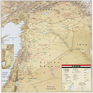
Syria is located in Western Asia, north of the Arabian Peninsula, at the eastern end of the Mediterranean Sea. It is bordered by Turkey to the north, Lebanon and Palestine to the west and southwest, Iraq to the east, and Jordan to the south. It consists of mountain ranges in the west and a steep area inland. In the east is the Syrian Desert and in the south is the Jabal al-Druze Range. The former is bisected by the Euphrates valley. A dam built in 1973 on the Euphrates created a reservoir named Lake Assad, the largest lake in Syria. The highest point in Syria is Mount Hermon on the Lebanese border. Between the humid Mediterranean coast and the arid desert regions lies a semiarid steep zone extending across three-quarters of the country, which receives hot, dry winds blowing across the desert. Syria is extensively depleted, with 28 percent of the land arable, 4 percent dedicated to permanent crops, 46 percent utilized as meadows and pastures, and only 3 percent forest and woodland.

Yemen is located in Southwest Asia, at the southern tip of the Arabian Peninsula, between Oman and Saudi Arabia. It is situated at the entrance to the Bab-el-Mandeb Strait, which links the Red Sea to the Indian Ocean and is one of the most active and strategic shipping lanes in the world. Yemen has an area of 527,970 square kilometres (203,850 sq mi), including the islands of Perim at the southern end of the Red Sea and Socotra at the entrance to the Gulf of Aden. Yemen's land boundaries total 1,746 kilometres (1,085 mi). Yemen borders Saudi Arabia to the north and Oman to the northeast. Through the Socotra island, Yemen also shares borders with the Guardafui Channel and the Somali Sea.

Somalia is a country located in the Horn of Africa which officially consists of the intra-46th meridian east territory, the five federal member states, namely Galmudug, Hirshabelle, Jubaland, South West, Puntland and the municipality of Benadir. It is bordered by Ethiopia to the west, the Gulf of Aden to the north, the Somali Sea and Guardafui Channel to the east, and Kenya to the southwest. With a land area of 637,657 square kilometers, Somalia's terrain consists mainly of plateaus, plains and highlands. Its coastline is more than 3,333 kilometers in length, the longest of mainland Africa. It has been described as being roughly shaped "like a tilted number seven".

Sclerophyll is a type of vegetation that is adapted to long periods of dryness and heat. The plants feature hard leaves, short internodes and leaf orientation which is parallel or oblique to direct sunlight. The word comes from the Greek sklēros (hard) and phyllon (leaf). The term was coined by A.F.W. Schimper in 1898, originally as a synonym of xeromorph, but the two words were later differentiated.

The Sonoran Desert is a North American desert and ecoregion that covers large parts of the southwestern United States, as well as the northwestern Mexican states of Sonora, Baja California, and Baja California Sur. It is the hottest desert in both Mexico and the United States. It has an area of 260,000 square kilometers (100,000 sq mi).

The Kwazulu-Cape coastal forest mosaic is a subtropical moist broadleaf forest ecoregion of South Africa. It covers an area of 17,800 square kilometers (6,900 sq mi) in South Africa's Eastern Cape and KwaZulu-Natal provinces.

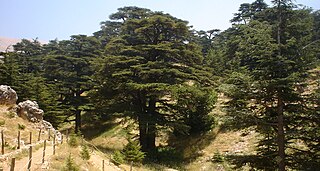
The Eastern Mediterranean conifer-sclerophyllous-broadleaf forests, also known as the Eastern Mediterranean conifer-broadleaf forests, is an ecoregion in the eastern Mediterranean Basin. It covers portions of Turkey, Syria, Lebanon, Israel, Palestinian territories, Jordan, and Saudi Arabia.

The Mediterranean dry woodlands and steppe is a Mediterranean forests, woodlands, and scrub ecoregion of North Africa. It occupies interior plateaus and mountain ranges of the Maghreb region, lying generally between the coastal Mediterranean woodlands and forests to the north and the Sahara to the south.

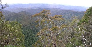
The Eastern Australian temperate forests is a broad ecoregion of open forest on uplands starting from the east coast of New South Wales in the South Coast to southern Queensland, Australia. Although dry sclerophyll and wet sclerophyll eucalyptus forests predominate within this ecoregion, a number of distinguishable rainforest communities are present as well.

The Carpentaria tropical savanna is a tropical and subtropical grasslands, savannas, and shrublands ecoregion in northern Australia.

The West Sudanian savanna is a tropical savanna ecoregion that extends across West Africa.

The Southern Anatolian montane conifer and deciduous forests ecoregion, in the Mediterranean forests, woodlands, and scrub biome, is in the eastern Mediterranean Basin.
The wildlife of Yemen is substantial and varied. Yemen is a large country in the southern half of the Arabian Peninsula with several geographic regions, each with a diversity of plants and animals adapted to their own particular habitats. As well as high mountains and deserts, there is a coastal plain and long coastline. The country has links with Europe and Asia, and the continent of Africa is close at hand. The flora and fauna have influences from all these regions and the country also serves as a staging post for migratory birds.

The Somali montane xeric shrublands is a desert and xeric scrubland ecoregion in Somalia. The ecoregion lies in the rugged Karkaar Mountains, which run parallel and close to Somalia's northern coast on the Gulf of Aden, and follows coast from Cape Guardafui south to Eyl on the Arabian Sea.

The Southwestern Arabian foothills savanna, also known as the Southwestern Arabian Escarpment shrublands and woodlands, is a desert and xeric shrubland ecoregion of the southern Arabian Peninsula, covering portions of Saudi Arabia, Yemen, and Oman.

The Jordanian Highlands is a mountain range in Jordan. It extends north and south through the western portion of the country, between the Red Sea-Dead Sea depression to the west and a plateau to the east. The higlands are home to most of Jordan's population and large cities.


