Aspen is the home rule municipality that is the county seat and the most populous municipality of Pitkin County, Colorado, United States. Its population was 6,658 at the 2010 United States Census. Aspen is in a remote area of the Rocky Mountains' Sawatch Range and Elk Mountains, along the Roaring Fork River at an elevation just below 8,000 feet (2,400 m) above sea level on the Western Slope, 11 miles (18 km) west of the Continental Divide.

The Brooks Range is a mountain range in far northern North America stretching some 700 miles (1,100 km) from west to east across northern Alaska into Canada's Yukon Territory. Reaching a peak elevation of 8,976 feet (2,736 m) on Mount Isto, the range is believed to be approximately 126 million years old.

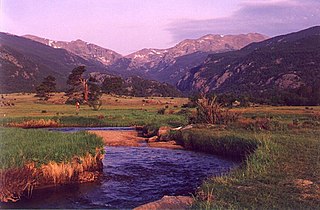
Rocky Mountain National Park is an American national park located approximately 76 mi (122 km) northwest of Denver International Airport in north-central Colorado, within the Front Range of the Rocky Mountains. The park is situated between the towns of Estes Park to the east and Grand Lake to the west. The eastern and westerns slopes of the Continental Divide run directly through the center of the park with the headwaters of the Colorado River located in the park's northwestern region. The main features of the park include mountains, alpine lakes and a wide variety of wildlife within various climates and environments, from wooded forests to mountain tundra.

Roaring Fork River is a tributary of the Colorado River, approximately 70 miles (110 km) long, in west central Colorado in the United States. The river drains a populated and economically vital area of the Colorado Western Slope called the Roaring Fork Valley or Roaring Fork Watershed, which includes the resort city of Aspen and the resorts of Aspen/Snowmass.

The Blue River is a tributary of the Colorado River, approximately 65 miles (105 km) long, in the U.S. state of Colorado.

The Fraser River is a tributary of the Colorado River, approximately 32.5 miles (52.3 km) long, in north central Colorado in the United States. It drains large portion of the Middle Park basin in Grand County in the Rocky Mountains west of Boulder and southwest of Rocky Mountain National Park. It rises at the continental divide on the north side of Berthoud Pass in the Arapaho National Forest. It flows NNW past Winter Park, Fraser, and Tabernash, and joins the Colorado River from the south two miles west of Granby.
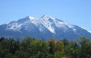
Mount Sopris is a twin-summit mountain in the northwestern Elk Mountains range of the Rocky Mountains of North America. The 12,965-foot (3,952 m) mountain is located in the Maroon Bells-Snowmass Wilderness of White River National Forest, 6.6 miles (10.7 km) north by northeast of the community of Redstone in Pitkin County, Colorado, United States.

Aspen Mountain is a mountain summit in the Elk Mountains range of the Rocky Mountains of North America. The 10,705-foot (3,263 m) peak is located in White River National Forest, 1.4 miles (2.2 km) south-southeast of downtown Aspen in Pitkin County, Colorado, United States. The north face of the mountain is the location of the Aspen Mountain ski area, one of four adjacent ski areas operated collectively as Aspen/Snowmass.
Aspen is a common name for several species of trees in the genus Populus.

Granby Dam is an earthfill dam that dams the Colorado River 5.5 miles (8.9 km) northeast of Granby, Colorado in Grand County, Colorado. This 298-foot (91 m)-tall dam was constructed between 1941 and 1950 and has a drainage area of 311 square miles (810 km2). The Granby Dam's reservoir is known as Lake Granby, the largest reservoir component of the Colorado-Big Thompson Project. Lake Granby stores Colorado River water that is diverted under the Continental Divide for agriculture and municipal use within north-eastern Colorado including the cities of Boulder, Fort Collins, Loveland, and Greeley. In addition to the waters of the Colorado, water from Willow Creek just below the dam is pumped up 175 feet (53 m) to Lake Granby. Water from Lake Granby is pumped 125 feet (38 m) higher by the Granby Pumping Plant to the Granby Pump Canal, which extents 1.8 miles (2.9 km) to Shadow Mountain Lake, from which water is diverted through the Alva B. Adams Tunnel to the East Slope.
Drake is an unincorporated community in Larimer County, Colorado located in the Big Thompson Canyon between Estes Park, Colorado and Loveland, Colorado near Rocky Mountain National Park. A U.S. Post Office is also situated in the county ZIP Code 80515. The 2010 population of Drake was 1,010. The last birth of a child in Drake occurred on the upper floor of the Old Horse Stall Building; June 10, 2001.
The Little Thompson River is a tributary of the Big Thompson River and thence the South Platte River in the U.S. state of Colorado.

River Bend Lodge is an unincorporated community in Riverside County, California, also known as Aha Quin. The community is near Hall Island along the Colorado River and hosts Riverside County Fire Department, Station 46. River Bend Lodge is also inside the Mojave Desert Air Quality Management District.

Chalk Creek is a 27.3-mile-long (43.9 km) river flowing east from the Collegiate Peaks mountain range in Chaffee County, Colorado. Mount Antero borders the southern side of the river, while Mount Princeton borders the northern side. The headwaters of the river are located at the Continental Divide. The river empties into the Arkansas River at the town of Nathrop, Colorado.

The Fall River is a 17.1-mile-long (27.5 km) tributary of the Big Thompson River in Larimer County, Colorado. The river's source is near the Alpine Visitor Center in Rocky Mountain National Park. It flows down a canyon and over Chasm Falls before a confluence with the Big Thompson in Estes Park.
The North Fork Big Thompson River is a 22.7-mile-long (36.5 km) tributary of the Big Thompson River in Larimer County, Colorado. The river's source is Rowe Glacier on the north slope of Hagues Peak, in the Mummy Range of Rocky Mountain National Park. It flows through Lake Dunraven, over Lost Falls and through Glen Haven before a confluence with the Big Thompson in Drake.
Rowe Glacier is an alpine glacier in Rocky Mountain National Park in the U.S. state of Colorado. Rowe Glacier is 300 yd (270 m) north of Hagues Peak and is the source of the North Fork Big Thompson River. Rowe Glacier was the first glacier to be identified in Colorado.
Wind River is a tributary of Aspen Brook in Larimer County, Colorado. The stream flows northeast from a source in Rocky Mountain National Park to a confluence with Aspen Brook in the Roosevelt National Forest.