
Peterborough is a cathedral city in Cambridgeshire, England, with a population of 202,110 in 2017. Historically part of Northamptonshire, it is 76 miles (122 km) north of London, on the River Nene which flows into the North Sea 30 miles (48 km) to the north-east. The railway station is an important stop on the East Coast Main Line between London and Edinburgh. Peterborough is also the largest city and borough in Cambridgeshire and the East Anglia area of England.

British Waterways, often shortened to BW, was a statutory corporation wholly owned by the government of the United Kingdom. It served as the navigation authority for the majority of canals and a number of rivers and docks in England, Scotland and Wales.
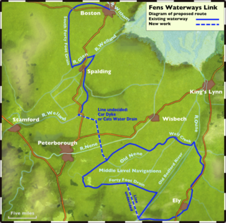
The River Nene is a river in the east of England that rises from three sources in Northamptonshire. The tidal river is about 100 miles (160 km) long, about 3.7 miles (6.0 km) of which forms the border between Cambridgeshire and Norfolk. It is the tenth-longest river in the United Kingdom, and is navigable for 88 miles (142 km), from Northampton to The Wash.

The River Great Ouse is a river in the United Kingdom, the longest of several British rivers called "Ouse". From Syresham in central England, the Great Ouse flows into East Anglia before entering the Wash, a bay of the North Sea. With a course of 143 miles (230 km), mostly flowing north and east, it is the fourth longest river in the United Kingdom. The Great Ouse has been historically important for commercial navigation, and for draining the low-lying region through which it flows; its best-known tributary is the Cam, which runs through Cambridge. Its lower course passes through drained wetlands and fens and has been extensively modified, or channelised, to relieve flooding and provide a better route for barge traffic. Though the unmodified river probably changed course regularly after floods, it now enters the Wash after passing through the port of King's Lynn, south of its earliest-recorded route to the sea.
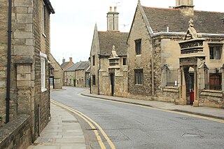
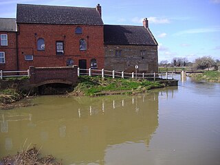
Oundle is a market town on the River Nene in Northamptonshire, England, which had a population of 5,735 at the time of the 2011 census. It is 69 miles north of London and 12 mi (19 km) south-west of Peterborough. The nearest railway station, Corby, is 9.3 mi (15.0 km) to the west.

The South Forty-Foot Drain, also known as the Black Sluice Navigation, is the main channel for the land-drainage of the Black Sluice Level in the Lincolnshire Fens. It lies in eastern England between Guthram Gowt and the Black Sluice pumping station on The Haven, at Boston. The Drain has its origins in the 1630s, when the first scheme to make the Fen land available for agriculture was carried out by the Earl of Lindsey, and has been steadily improved since then. Water drained from the land entered The Haven by gravity at certain states of the tide until 1946, when the Black Sluice pumping station was commissioned.
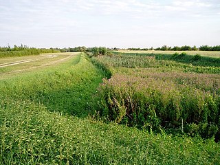
The Car Dyke was, and to a large extent still is, an 85-mile (137 km) long ditch which runs along the western edge of the Fens in eastern England. It is generally accepted as being of Roman age and, for many centuries, to have been taken as marking the western edge of the Fens. There, the consensus begins to break down.

Fletton is a residential area and electoral ward of the city of Peterborough, Cambridgeshire, England. For parliamentary purposes it falls within North West Cambridgeshire constituency.

Woodston is a largely residential area of the city of Peterborough, Cambridgeshire in the United Kingdom. For electoral purposes, it forms part of Fletton ward in North West Cambridgeshire constituency.
The A605 road is a main road in the English counties of Northamptonshire and Cambridgeshire.

Nautical tourism, also called water tourism, is tourism that combines sailing and boating with vacation and holiday activities. It can be travelling from port to port in a cruise ship, or joining boat-centered events such as regattas or landing a small boat for lunch or other day recreation at specially prepared day boat-landings. It is a form of tourism that is generally more popular in the summertime.

The Middle Level Navigations are a network of waterways in England, primarily used for land drainage, which lie in The Fens between the Rivers Nene and Great Ouse, and between the cities of Peterborough and Cambridge. Most of the area through which they run is at or below sea level, and attempts to protect it from inundation have been carried out since 1480. The Middle Level was given its name by the Dutch Engineer Cornelius Vermuyden in 1642, who subsequently constructed several drainage channels to make the area suitable for agriculture. Water levels were always managed to allow navigation, and Commissioners were established in 1754 to maintain the waterways and collect tolls from commercial traffic.

The Fens Waterways Link is a project to improve recreational boating opportunities in the counties of Cambridgeshire and Lincolnshire, England. By a combination of improvements to existing waterways and the construction of new links a circular route between Lincoln, Peterborough, Ely and Boston is planned. The project is being organised by the Environment Agency and financed from the Regional Development Agency and the European Union.

Fairline Boats was a British manufacturer of luxury motor yachts. Started in 1963 by Jack Newington, the company built motor yachts in Oundle, Northamptonshire.
A navigation authority is a company or statutory body which is concerned with the management of a navigable canal or river.

The Wisbech Canal was a broad canal near Wisbech in the Fenland area of Cambridgeshire, England. It ran from the River Nene at Wisbech to the Well Creek at Outwell in Norfolk, which gave access to the River Great Ouse. It was abandoned in 1926 and filled in during the 1970s.
The Association of Waterways Cruising clubs is a waterway society and umbrella organisation in England, UK. It was founded in the early 1960s by the St Pancras, Dunstable, Uxbridge and Lee and Stort boat clubs as an inter-club scheme for an emergency service for boaters, and for safe overnight moorings.
The Great Ouse Boating Association (GOBA) is a waterway society on the rivers Great Ouse, River Cam, Lark, Little Ouse, River Wissey, and associated waterways in East Anglia.
The Fens and Anglian system is a collection of rivers in East Anglia in England that are navigable and for which the Environment Agency is the navigation authority.


