
Dronfield is a town in North East Derbyshire, England, which includes Dronfield Woodhouse and Coal Aston. It lies in the valley of the River Drone between Chesterfield and Sheffield. The Peak District National Park is three miles (4.8 km) to the west. The name means open land infested with drones.

Chellaston is a suburban village on the southern outskirts of Derby, a city in Derbyshire in the East Midlands of England. It is situated on a natural hill, and has developed into a residential suburb as Derby has expanded.

Aston-on-Trent is a village and civil parish in the South Derbyshire district, in the county of Derbyshire, England. The parish had a population of 1,682 at the 2011 Census. It is adjacent to Weston-on-Trent and near Chellaston, very close to the border with Leicestershire.

Lathkill Dale is the valley of the River Lathkill near Bakewell, Derbyshire in the Peak District of England. The river emerges into the dale from springs below Lathkill Head Cave. Towards the head of the dale is the side valley Cales Dale.

Shardlow is a village in Derbyshire, England about 6 miles (9.7 km) southeast of Derby and 11 miles (18 km) southwest of Nottingham. Part of the civil parish of Shardlow and Great Wilne, and the district of South Derbyshire, it is also very close to the border with Leicestershire, defined by route of the River Trent which passes close to the south. Just across the Trent is the Castle Donington parish of North West Leicestershire.

Ashford-in-the-Water is a village in the Derbyshire Peak District, England, and on the River Wye. It is known for the quarrying of Ashford Black Marble, and for the maidens' garlands made to mark the deaths of virgins in the village until 1801. Some of these are preserved in the parish church. The civil parish population taken at the 2011 Census was 559.

Stretton en le Field is a small village and civil parish in the North West Leicestershire district of Leicestershire, England, about 7 miles/11 km south-west of Ashby de la Zouch, historically an exclave of Derbyshire. According to the 2001 census, the parish had a population of 36. At the 2011 census the population remained under 100 and so was included in the civil parish of Chilcote. Stretton Bridge carries the A444 road across the River Mease, which forms the northern parish boundary. It is among the Thankful Villages, suffering no Great War fatalities in 1914–1918: eleven men went from the village to fight and all returned.
Hatton is a village and civil parish in South Derbyshire, England. It is 6 kilometres (3.7 mi) north of Burton upon Trent, 20 kilometres (12 mi) west of Derby and 40 kilometres (25 mi) east of Stoke-on-Trent. The population of the civil parish as of the 2011 census was 2,785.

Barlow is a village and civil parish in the North East Derbyshire district of Derbyshire, England. According to the 2001 census the parish had a population of 884, increasing to 920 at the 2011 Census. The village is about 4 miles north-west of Chesterfield.

Bilsby is a village and civil parish in the East Lindsey district of Lincolnshire, England. It lies on the main A1111 road between Alford and Sutton-on-Sea, 1 mile (1.6 km) east of Alford. Thurlby and Asserby are hamlets within Bilsby parish. According to the 2001 census, the parish had a population of 415, which increased to 487 at the 2011 Census.
Swarkestone is a village and civil parish in the South Derbyshire district of Derbyshire, England. The population at the 2011 Census was 187.

Bradley is a village and civil parish in Derbyshire just east of Ashbourne. The population of the civil parish taken at the 2011 Census was 313. Other neighbouring parishes include Hulland and Yeldersley.

The Parish Church of St Peter and St Paul in Witton Lane, Aston, Birmingham, England, is a parish church in the Church of England.

Aston is a village in the civil parish of Newhall in the unitary authority of Cheshire East and the ceremonial county of Cheshire, England.

Aston is a residential village in the Metropolitan Borough of Rotherham, South Yorkshire, England. The village falls within the Holderness ward of the borough. Aston is approximately 2 miles (3 km) from Rother Valley Country Park.
Conksbury is the site of a deserted medieval settlement between Over Haddon and Youlgreave in Derbyshire, England.

Poole is a civil parish in the unitary authority of Cheshire East and the ceremonial county of Cheshire, England, which lies to the north west of Nantwich and to the west of Crewe. The Shropshire Union Canal runs through the parish. Nearby villages include Acton, Aston juxta Mondrum, Barbridge, Stoke Bank, Rease Heath and Worleston.

Leigh is a civil parish in the English county of Staffordshire. The parish includes the village of Church Leigh, together with the settlements of Withington, Upper Leigh, Lower Leigh, Morrilow Heath, Middleton Green, Dods Leigh, Godstone and Field.

St Wilfrid’s Church, Barrow upon Trent is a Grade I listed parish church in the Church of England in Barrow upon Trent, Derbyshire.
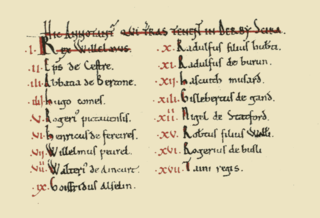
The Domesday Book of 1086 AD lists King William the Conqueror's tenants-in-chief in Derbyscire (Derbyshire), following the Norman Conquest of England:
