Related Research Articles

An escarpment is a steep slope or long cliff that forms as a result of faulting or erosion and separates two relatively level areas having different elevations.

In geology, a fault is a planar fracture or discontinuity in a volume of rock across which there has been significant displacement as a result of rock-mass movements. Large faults within Earth's crust result from the action of plate tectonic forces, with the largest forming the boundaries between the plates, such as the megathrust faults of subduction zones or transform faults. Energy release associated with rapid movement on active faults is the cause of most earthquakes. Faults may also displace slowly, by aseismic creep.
Landforms are categorized by characteristic physical attributes such as their creating process, shape, elevation, slope, orientation, rock exposure, and soil type.

The North Cascades are a section of the Cascade Range of western North America. They span the border between the Canadian province of British Columbia and the U.S. state of Washington and are officially named in the U.S. and Canada as the Cascade Mountains. The portion in Canada is known to Americans as the Canadian Cascades, a designation that also includes the mountains above the east bank of the Fraser Canyon as far north as the town of Lytton, at the confluence of the Thompson and Fraser Rivers.

A ridge is a long, narrow, elevated geomorphologic landform, structural feature, or a combination of both separated from the surrounding terrain by steep sides. The sides of a ridge slope away from a narrow top, the crest or ridgecrest, with the terrain dropping down on either side. The crest, if narrow, is also called a ridgeline. Limitations on the dimensions of a ridge are lacking. Its height above the surrounding terrain can vary from less than a meter to hundreds of meters. A ridge can be either depositional, erosional, tectonic, or a combination of these in origin and can consist of either bedrock, loose sediment, lava, or ice depending on its origin. A ridge can occur as either an isolated, independent feature or part of a larger geomorphological and/or structural feature. Frequently, a ridge can be further subdivided into smaller geomorphic or structural elements.
The exposed geology of the Death Valley area presents a diverse and complex set of at least 23 formations of sedimentary units, two major gaps in the geologic record called unconformities, and at least one distinct set of related formations geologists call a group. The oldest rocks in the area that now includes Death Valley National Park are extensively metamorphosed by intense heat and pressure and are at least 1700 million years old. These rocks were intruded by a mass of granite 1400 Ma and later uplifted and exposed to nearly 500 million years of erosion.

A fault scarp is a small step or offset on the ground surface where one side of a fault has moved vertically with respect to the other. It is the topographic expression of faulting attributed to the displacement of the land surface by movement along faults. They are exhibited either by differential movement and subsequent erosion along an old inactive geologic fault, or by a movement on a recent active fault.

A meander is one of a series of regular sinuous curves in the channel of a river or other watercourse. It is produced as a watercourse erodes the sediments of an outer, concave bank and deposits sediments on an inner, convex bank which is typically a point bar. The result of this coupled erosion and sedimentation is the formation of a sinuous course as the channel migrates back and forth across the axis of a floodplain.
Fault blocks are very large blocks of rock, sometimes hundreds of kilometres in extent, created by tectonic and localized stresses in Earth's crust. Large areas of bedrock are broken up into blocks by faults. Blocks are characterized by relatively uniform lithology. The largest of these fault blocks are called crustal blocks. Large crustal blocks broken off from tectonic plates are called terranes. Those terranes which are the full thickness of the lithosphere are called microplates. Continent-sized blocks are called variously microcontinents, continental ribbons, H-blocks, extensional allochthons and outer highs.

Loss Creek is a stream in the Capital Regional District of British Columbia, Canada. Located on southern Vancouver Island, it flows through a long, steep-sided valley to the Strait of Juan de Fuca on the Pacific Ocean.
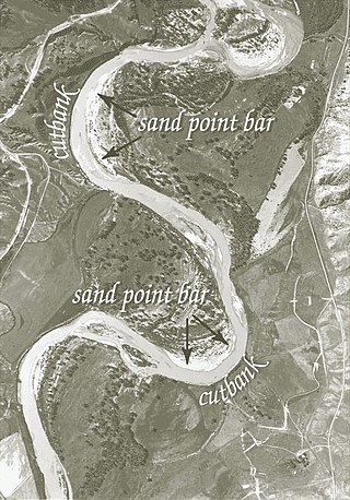
A cut bank, also known as a river cliff or river-cut cliff, is the outside bank of a curve or meander in a water channel (stream), which is continually undergoing erosion. Cut banks are found in abundance along mature or meandering streams, they are located on the outside of a stream bend, known as a meander, opposite the slip-off slope on the inside of the bend. They are shaped much like a small cliff, and are formed by the erosion of soil as the stream collides with the river bank. As opposed to a point bar, which is an area of deposition, a cut bank is an area of erosion.

Simi Valley is a synclinal valley in Southern California in the United States. It is an enclosed or hidden valley surrounded by mountains and hills. It is connected to the San Fernando Valley to the east by the Santa Susana Pass and the 118 freeway, and in the west the narrows of the Arroyo Simi and the Reagan Freeway connection to Moorpark. The relatively flat bottom of the valley contains soils formed from shales, sandstones, and conglomerates eroded from the surrounding hills of the Santa Susana Mountains to the north, which separate Simi Valley from the Santa Clara River Valley, and the Simi Hills.
The Philippine Fault System is a major inter-related system of geological faults throughout the whole of the Philippine Archipelago, primarily caused by tectonic forces compressing the Philippines into what geophysicists call the Philippine Mobile Belt. Some notable Philippine faults include the Guinayangan, Masbate and Leyte faults.
The 1974 Zhaotong earthquake occurred at 3:25 in the morning local time on 11 May 1974, with a Coordinated Universal Time (UTC) time of 19:25:16 on 10 May. It had a magnitude that was measured at 7.0 on the moment magnitude scale and 7.1 on the surface wave magnitude scale. It had a maximum perceived intensity of IX (Violent) on the Mercalli intensity scale. The epicenter was located in Zhaotong prefecture in Yunnan province and it caused between 1,641 and 20,000 deaths.
A half-graben is a geological structure bounded by a fault along one side of its boundaries, unlike a full graben where a depressed block of land is bordered by parallel faults.

A slip-off slope is a depositional landform that occurs on the inside convex bank of a meandering river. The term can refer to two different features: one in a freely meandering river with a floodplain and the other in an entrenched river.

The El Tigre Fault is a 120 km long, roughly north-south trending, major strike-slip fault located in the Western Precordillera in Argentina. The Precordillera lies just to the east of the Andes mountain range in South America. The northern boundary of the fault is the Jáchal River and its southern boundary is the San Juan River. The fault is divided into three sections based on fault trace geometry, Northern extending between 41–46 km in length, Central extending between 48–53 km in length, and Southern extending 26 km in length. The fault displays a right-lateral (horizontal) motion and has formed in response to stresses from the Nazca Plate subducting under the South American Plate. It is a major fault with crustal significance. The Andes Mountain belt trends with respect to the Nazca Plate/South American Plate convergence zone, and deformation is divided between the Precordilleran thrust faults and the El Tigre strike-slip motion. The El Tigre Fault is currently seismically active.

In geology, 3D fold evolution is the study of the full three dimensional structure of a fold as it changes in time. A fold is a common three-dimensional geological structure that is associated with strain deformation under stress. Fold evolution in three dimensions can be broadly divided into two stages, namely fold growth and fold linkage. The evolution depends on fold kinematics, Fold mechanism, as well as a reporting of the history behind folds and relationships by which fold age is understood. There are several ways to reconstruct the evolution progress of folds, notably by using depositional evidence, geomorphological evidence and balanced restoration.
The Usme Fault is a dextral oblique normal fault in the department of Cundinamarca in central Colombia. The fault has a total length of 64.9 kilometres (40.3 mi) and runs along an average north-northeast to south-southwest strike of 022.7 ± 6 in the Eastern Ranges of the Colombian Andes.
The 1885 Kashmir earthquake, also known as the Baramulla earthquake occurred on 30 May in Srinagar. It had an estimated moment magnitude of Mw 6.3–6.8 and maximum Medvedev–Sponheuer–Karnik scale intensity of VIII (Damaging). At least 3,081 people died and severe damage resulted.
References
- ↑ French, Hugh M. (2007). The Periglacial Environment (3rd ed.). John Wiley & Sons Ltd. pp. 263–264. ISBN 978-0-470-86588-0.
- ↑ Zhang, Ke; Liu, Kaiyu; Yang, Jinchun (2004). "Asymmetrical valleys created by the geomorphic response of rivers to strike-slip fault". Quaternary Research . 62: 310–315.
| | This geomorphology article is a stub. You can help Wikipedia by expanding it. |