Atoka County, Choctaw Nation

Last updated
Oklahoma and Indian Territory, 1890s Okterritory.png
Oklahoma and Indian Territory, 1890s

Atoka County was a political subdivision of the Choctaw Nation of Indian Territory, prior to Oklahoma being admitted as a state. The county formed part of the Nation's Pushmataha District, or Third District, one of three administrative and judicial provinces called districts.

Contents

History

The county was created in 1850 as Shappaway County, a name it held until 1854. Shappaway was a corruption of the Chickasaw or Choctaw words, shapah, or “flag,” and welih, “to hold up to view.” In late 1854 the General Council of the Choctaw Nation renamed it Atoka County in honor of Captain William Atoka. His surname, “Atoka,” is derived from the Choctaw word hitoka or hetoka, meaning “ball ground.” [1]

Captain Atoka was a noted athlete, distinguishing himself on the stickball playing field. Those who excelled in stickball were thought to be strong, brave, courageous, and intelligent. Atoka was a leader before the Choctaw removed to the west of the Mississippi River; he was a co-signer of the Treaty of Dancing Rabbit Creek in 1830.

Atoka lived in several locations in and around the present-day town of Atoka, dying at his home in October 1876. His grave was protected by a shed, which was maintained by friends and neighbors until Oklahoma's statehood. It remained in place through at least 1937. [2]

The county seat of Atoka County was the town of Atoka. This county was unusual among the Choctaw Nation's 19 counties for having a county seat that was also a population center. County seats were generally campgrounds used for tribal judicial or other proceedings. They had few if any permanent residents. Atoka, by contrast, was served by a railroad and developed as a trading center.

Atoka County's seat of government was located approximately one mile east of the present-day city of Atoka, Oklahoma. Although it leads in that general direction, modern-day Court Street does not reference the Atoka County Courthouse but, rather, a territorial-era United States Courthouse which was located on the street. [3]

Atoka County's boundaries were established and designated according to easily recognizable natural landmarks, as were the boundaries of all Choctaw Nation counties. Its western boundary was the Choctaw Nation's western boundary with the Chickasaw Nation. Clear Boggy Creek formed most of its southern border, and Muddy Boggy Creek and North Boggy Creek formed its eastern borders. Its northern border skirted the Shawnee Hills to their south and connected with North Boggy Creek.

Atoka County served as an election district for members of the National Council; it was also a unit of local administration. Constitutional officers, all of whom served for two-year terms and were elected by the voters, included the county judge, sheriff, and a ranger. The judge's duties included oversight of overall county administration. The sheriff collected taxes, monitored unlawful intrusion by intruders (usually white Americans from the United States), and conducted the census. The county ranger advertised and sold strayed livestock. [4]

Statehood

As Oklahoma's statehood approached, its leading citizens, who were gathered for the Oklahoma Constitutional Convention, realized in laying out the future state's counties that, while logically designed, most of the Choctaw Nation's counties could not exist as economically viable political subdivisions. In most the county seat existed generally for holding county court and not as a population center. This was not true of the town of Atoka, nor was it true of Atoka County, which included large coal mines at Atoka, Coalgate and Lehigh within its territory. While Atoka County contained more sizable towns and industry than most, it would have to be dismantled in order to accommodate changes required by the region at large.

This conundrum was also recognized by the framers of the proposed State of Sequoyah, who met in 1905 to propose statehood for the Indian Territory. The Sequoyah Constitutional Convention also proposed a county structure that abolished the Choctaw counties. Atoka County was divided principally into the proposed Bixby, Blue, and Moseley counties. In so doing Sequoyah's framers first established the separation of Coalgate and Lehigh into their own county (Moseley County), separate from Atoka (in Bixby County), despite the short distance between the towns. [5]

Much of this proposition was borrowed by Oklahoma's framers two years later, who largely adopted the eastern boundary of the proposed Bixby County for the future Atoka County in Oklahoma and formalized the split-off of Coalgate and Lehigh into an adjacent county.

The territory comprising Atoka County, Choctaw Nation now falls within the present-day Atoka, Coal, Hughes, and Pittsburg counties. Atoka County ceased to exist upon Oklahoma's statehood on November 16, 1907.

Related Research Articles

<span class="mw-page-title-main">Coal County, Oklahoma</span> County in Oklahoma, United States

Coal County is a county located in the U.S. state of Oklahoma. As of the 2020 census, the population was 5,266. Its county seat is Coalgate.

Kiamitia County, also known as Kiamichi County, was a political subdivision of the Choctaw Nation, Indian Territory. The county formed part of the nation's Pushmataha District, or Third District, one of three administrative super-regions.

Jack's Fork County, also known as Jack Fork County, was a political subdivision of the Choctaw Nation of Indian Territory. The county formed part of the nation's Pushmataha District, or Third District, one of three administrative super-regions.

Jackson County was a political subdivision of the Choctaw Nation of Indian Territory, prior to Oklahoma being admitted as a state. The county formed part of the Nation's Pushmataha District, or Third District, one of three administrative super-regions.

Nashoba County was a political subdivision of the Choctaw Nation of Indian Territory. The county formed part of the Nation’s Apukshunnubbee District, or Second District, one of three administrative super-regions in the Nation. This territory was later made part of the state of Oklahoma.

Blue County was a political subdivision of the Choctaw Nation of Indian Territory, prior to Oklahoma being admitted as a state. The county formed part of the Nation’s Pushmataha District, or Third District, one of three administrative super-regions.

<span class="mw-page-title-main">Pushmataha County, Sequoyah</span> Proposed U.S. political subdivision

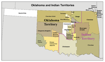
Pushmataha County was a proposed political subdivision created by the Sequoyah Constitutional Convention. The convention, meeting in Muskogee, Indian Territory in 1905, established the political and administrative layout of a prospective U.S. state it called the State of Sequoyah.

Wade County was a political subdivision of the Choctaw Nation of Indian Territory, prior to Oklahoma being admitted as a state. The county formed part of the Nation's Apukshunnubbee District, or First District, one of three administrative super-regions.

The Atoka Agreement is a document signed by representatives of the Choctaw and Chickasaw Indian Nations and members of the United States Dawes Commission on April 23, 1897, at Atoka, Indian Territory. It provided for the allotment of communal tribal lands of the Choctaw and Chickasaw nations in the Indian Territory to individual households of members of the tribes, who were certified as citizens of the tribes. Land in excess of the allotments could be sold to non-natives. Provisions of this agreement were later incorporated into the Curtis Act of 1898, which provided for widespread allotment of communal tribal lands.

Towson County was a political subdivision of the Choctaw Nation of Indian Territory, prior to Oklahoma being admitted as a state. The county formed part of the Nation's Apukshunnubbee a District, or Second District, one of three administrative super-regions.

Bok Tuklo County was a political subdivision of the Choctaw Nation of Indian Territory, prior to Oklahoma being admitted as a state. The county formed part of the Nation’s Apukshunnubbee District, or Second District, one of three administrative super-regions. The subdivision was located within the current McCurtain County.

Bok Tuklo County was a political subdivision of the Choctaw Nation of Indian Territory, prior to Oklahoma being admitted as a state. The county formed part of the Nation’s Apukshunnubbee District, or Second District, one of three administrative super-regions.

Eagle County was a political subdivision of the Choctaw Nation of Indian Territory, prior to Oklahoma being admitted as a state. The county formed part of the Nation's Apukshunnubbee District, or Second District, one of three administrative super-regions.

Red River County was a political subdivision of the Choctaw Nation of Indian Territory, prior to Oklahoma being admitted as a state. The county formed part of the Nation's Apukshunnubbee District, or Second District, one of three administrative super-regions.

Skullyville County was a political subdivision of the Choctaw Nation of Indian Territory, prior to Oklahoma being admitted as a state. The county formed part of the Nation's Moshulatubbee District, or First District, one of three administrative super-regions.

Sans Bois County was a political subdivision of the Choctaw Nation of Indian Territory, prior to Oklahoma being admitted as a state. The county formed part of the Nation's Moshulatubbee District, or First District, one of three administrative super-regions.

Sugar Loaf County was a political subdivision of the Choctaw Nation of Indian Territory, prior to Oklahoma being admitted as a state. The county formed part of the Nation's Moshulatubbee District, or First District, one of three administrative super-regions.

Gaines County was a political subdivision of the Choctaw Nation of Indian Territory, prior to Oklahoma being admitted as a state. The county formed part of the Nation's Moshulatubbee District, or First District, one of three administrative super-regions.

Tobucksy County was a political subdivision of the Choctaw Nation in the Indian Territory, prior to Oklahoma becoming a state. It was part of the Moshulatubbee District, or First District, one of three administrative and judicial provinces.

<span class="mw-page-title-main">Pickens County, Chickasaw Nation</span> Political subdivision of Chickasaw Nation

Pickens County was a political subdivision of the Chickasaw Nation in the Indian Territory from 1855, prior to Oklahoma being admitted as a state in 1907. The county was one of four that comprised the Chickasaw Nation. Following statehood, its territory was divided among several Oklahoma counties that have continued to the present.

References

  1. "Organization of Counties in the Choctaw and Chickasaw Nations." Chronicles of Oklahoma. Vol. 8, No. 3: 324, 330. September 1930.
  2. “William Atoka Biography,” Indian-Pioneer Papers, Western History Collections, University of Oklahoma Libraries; “Organization of Counties in the Choctaw and Chickasaw Nations,” Chronicles of Oklahoma, Vol. 8, No. 3, September 1930, pp. 317–318, 324, 330.
  3. A 1921 letter written by missionary Joseph S. Murrow, who ministered to the Choctaw Indians at Atoka and was a Confederate government official, noted the court grounds' location. See the reprint appearing in the interview with Mrs. Charles Maxwell, Indian-Pioneer Papers, Western History Collections of the University of Oklahoma Libraries. The location of the United States Courthouse is seen on Sanborn Fire Insurance Company maps held by the Library of Congress. Court Street was originally Hill Street, then 5th Street, and, after establishment of the United States Court, Court Street.
  4. Constitution and Laws of the Choctaw Nation, 1890, p. 312; John W. Morris, Historical Atlas of Oklahoma, plates 38 & 56; and Angie Debo, The Rise and Fall of the Choctaw Republic, p. 152.
  5. Amos Maxwell, Sequoyah Constitutional Convention. Although the map carried in Wikipedia’s article on the State of Sequoyah speaks to the matter of borders, Maxwell’s book offers further insight.