
The Isthmus of Tehuantepec is an isthmus in Mexico. It represents the shortest distance between the Gulf of Mexico and the Pacific Ocean. Prior to the opening of the Panama Canal, it was a major shipping route known simply as the Tehuantepec Route. The name is taken from the town of Santo Domingo Tehuantepec in the state of Oaxaca; this was derived from the Nahuatl term tecuani-tepec.

San Pedro Pochutla is a city and municipality located in the south of Oaxaca state, Mexico next to the Pacific Ocean. It is an important commercial, transportation and administrative hub for the Pochutla District in the east of the Costa Region. Pochutla is located at the junction of coastal Highway 200 and Highway 175 to Oaxaca, with 175 functioning as the town’s main thoroughfare. Its name means "place of kapok trees ", and most of the city is built on a lakebed which was drained during the colonial period. The municipality is best known as being the home of the oceanside communities of Puerto Ángel and Zipolite.
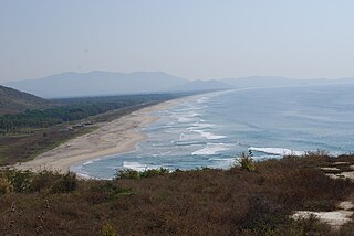
The Laguna de Manialtepec is a coastal lagoon about 18 km west of Puerto Escondido in the State of Oaxaca, Mexico. The name comes from Náhuatl “manial” (spring) and “tepec” (Hill), meaning. Access to the lagoon by car is via Federal Highway 200 or by boat from Puerto Escondido. The lagoon is 15 km long with patches of leafy jungle and mangroves that reach 15 meters of height in some places. The lagoon opens to the sea during the rainy season at a place known as Puerto Suelo or El Carnero.

The Lagunas de Chacahua National Park, created in 1937, is a national park located in the Municipality of Villa de Tututepec de Melchor Ocampo in the Mexican state of Oaxaca, about 54 km west of Puerto Escondido, near a village called Zapotalito. It can be reached via Federal Highway 200 or by boat from Puerto Escondido. The park encompasses 132.73 square kilometres, about 30 km² of which is taken by various lagoons such as the ‘’’Laguna de Chacahua,’’’ ‘’’Laguna de La Pastoria,’’’ and Laguna Las Salinas. There are various smaller lagoons that are connected by narrow channels. The rest of the park consists of dry land.
Costa Grande of Guerrero is a sociopolitical region located in the Mexican state of Guerrero, along the Pacific Coast. It makes up 325 km (202 mi) of Guerrero’s approximately 500 km (311 mi) coastline, extending from the Michoacán border to the Acapulco area, wedged between the Sierra Madre del Sur and the Pacific Ocean. Acapulco is often considered part of the Costa Grande; however, the government of the state classifies the area around the city as a separate region. The Costa Grande roughly correlates to the Cihuatlán province of the Aztec Empire, which was conquered between 1497 and 1504. Before then, much of the area belonged to a dominion under the control of the Cuitlatecs, but efforts by both the Purépecha Empire and Aztec Empire to expand into this area in the 15th century brought this to an end. Before the colonial period, the area had always been sparsely populated with widely dispersed settlements. The arrival of the Aztecs caused many to flee and the later arrival of the Spanish had the same effect. For this reason, there are few archeological remains; however, recent work especially at La Soledad de Maciel has indicated that the cultures here are more important than previously thought. Today, the area economically is heavily dependent on agriculture, livestock, fishing and forestry, with only Zihuatanejo and Ixtapa with significantly developed infrastructure for tourism. The rest of the coast has been developed spottily, despite some government efforts to promote the area.

Villa Sola de Vega is a town and municipality in Oaxaca in south-western Mexico, part of the Sola de Vega District in the Sierra Sur Region.
Villa de Tututepec de Melchor Ocampo is a town and municipality in Oaxaca in south-western Mexico.
The Atoyac River is a river of Mexico located in the federal district of Guerrero.

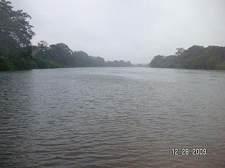
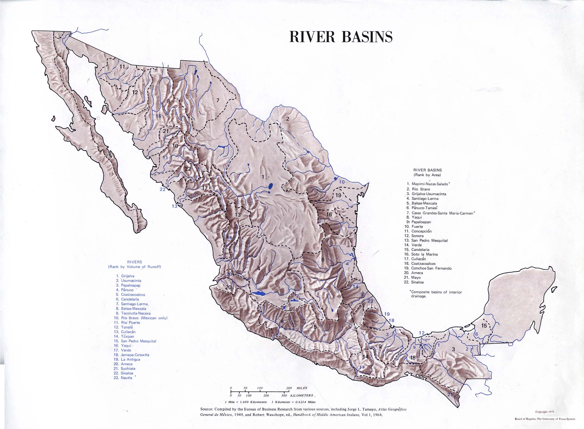
The Tehuantepec River is a river of Mexico located in Oaxaca. The mountainous terrain of the region it occupies allows for no navigable rivers; instead, there are a large number of smaller ones, which often change name from area to area. The continental divide passes through the state, meaning there is drainage toward both the Gulf of Mexico and the Pacific Ocean. Most of the drainage toward the Gulf is represented by the Papaloapan and Coatzacoalcos Rivers and their tributaries such as the Grande and Salado Rivers. Three rivers account for most of the water headed for the Pacific: the Atoyac River, Mixteco River, and the Tehuantepec River, with their tributaries.
The Mixteco River is a river of Mexico. The mountainous terrain of the region it occupies allows for no navigable rivers; instead, there are a large number of smaller ones, which often change name from area to area. The continental divide passes through the state, meaning that there is drainage towards both the Gulf of Mexico and the Pacific Ocean. Most of the drainage towards the Gulf is represented by the Papaloapan and Coatzacoalcos Rivers and their tributaries such as the Grande and Salado Rivers. Three rivers account for most of the water headed for the Pacific: the Atoyac River, Tehuantepec River, and the Mixteco River, with their tributaries.

Tulcingo (municipality) is a town and municipality in Puebla in south-eastern Mexico.
El Corte River is the primary tributary of the Coatzacoalcos River, flowing through the Mexican states of Oaxaca and Veracruz to the Gulf of Mexico.

Juquila District is located in the center of the Costa Region of the State of Oaxaca, Mexico, on the Pacific coast. It has an area of 5,055 km2. As of 2005 it had a total population of 134,365 of whom 33,106 spoke an indigenous language. Economic activities include agriculture and tourism. The Santuario (Sanctuary) de Juquila is a major attraction.
Juchitán District is located in the east of the Istmo de Tehuantepec region of the State of Oaxaca, Mexico, covering the southern part of a low-lying corridor through the mountains that separates the Gulf of Mexico from the Pacific ocean. The district has an area of 13,300 km2 and a population as of 2005 of 339,445.
According to the Mexican government agency Conapo, Oaxaca is the third most economically marginalized states in Mexico. The state has 3.3% of the population but produces only 1.5% of the GNP. The main reason for this is the lack of infrastructure and education, especially in the interior of the state outside of the capital. Eighty percent of the state’s municipalities do not meet federal minimums for housing and education. Most development projects are planned for the capital and the surrounding area. Little has been planned for the very rural areas and the state lacks the resources to implement them. The largest sector of Oaxaca’s economy is agriculture, mostly done communally in ejidos or similar arrangements. About 31% of the population is employed in agriculture, about 50% in commerce and services and 22% in industry. The commerce sector dominates the gross domestic product at 65.4%, followed by industry/mining at 18.9% and agriculture at 15.7%.
The Sierra Atravesada or Sierra de Niltepec is a mountain range in the state of Oaxaca, Mexico, in the region of the Isthmus of Tehuantepec.

Lagunas, Oaxaca is a town in the municipality of El Barrio de La Soledad, in the state of Oaxaca, Mexico It is located in the Isthmus of Tehuantepec in the municipality of El Barrio de la Soledad. Lagunas is the biggest and richest town in the municipality, with a population of 3,871 people. Matías Romero, Las Almoloyas, and El Barrio de la Soledad are all neighboring counties.

Tropical Storm Trudy was a short-lived tropical cyclone in October 2014 that caused significant flooding in southern Mexico. The storm originated from an area of low pressure associated with a monsoon trough near Central America in early October. A slow-moving system, the low eventually consolidated into a tropical depression on October 17 near the Mexican coastline. Favorable environmental conditions aided rapid development of Trudy. Within 15 hours of its designation, an eye formed over the storm's center. Trudy ultimately achieved its peak as a strong tropical storm with 65 mph (100 km/h) winds as it made landfall just southeast of Marquelia, Mexico. The region's mountainous terrain quickly weakened Trudy and the cyclone dissipated early on October 19. Though the cyclone dissipated, its remnant energy later contributed to the formation of Tropical Storm Hanna in the Atlantic.


