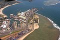
The Toamasina Province is a former province of Madagascar with an area of 71,911 km². It had a population of 2,855,600 (2004). Its capital was Toamasina, the most important seaport of the country. The province was also known as Tamatave Province.

Brickaville is a town and commune in Atsinanana Region, Madagascar.
Sava is a region in northern Madagascar. Its capital is Sambava. Until 2009 Sava belonged to Antsiranana Province. The region is situated at the northern part of the east coast of Madagascar. It is bordered by the region Diana to the north, Sofia to the west, and Analanjirofo to the south. As of 2018, its population was 1,123,013 and the total area is 25,518 km2 (9,853 sq mi). The region contains wild areas such as Marojejy National Park.
Articles related to Madagascar include:

Analamanga is a region in central Madagascar, containing the capital Antananarivo and its surrounding metropolitan area. The region has an area of 17,488 square kilometres, and had a population of 4,325.226 in 2018.

Fitovinany is a region located in southeast Madagascar. Its capital is Manakara. It is inhabited by the Antemoro people.

Analanjirofo is a region in northeastern Madagascar. Until 2009 it was a part of Toamasina Province. It borders Sava Region to the north, Sofia Region to the west, Alaotra-Mangoro Region to the southwest and Atsinanana Region to the south.

Alaotra-Mangoro is a region in eastern Madagascar. It borders Sofia Region in north, Analanjirofo in northeast, Atsinanana in east, Vakinankaratra in southwest, Analamanga in west and Betsiboka in northwest. The capital of the region is Ambatondrazaka, and the population was 1,255,514 in 2018. The area of the region is 31,948 km2 (12,335 sq mi).

Amoron'i Mania is a region in central Madagascar bordering Vakinankaratra Region in north, Atsinanana in northeast, Fitovinany in southeast, Haute Matsiatra in south, Atsimo-Andrefana in southwest and Menabe in west.
Betsiboka is a region of Madagascar. It borders Boeny Region in north, Sofia in northeast, Alaotra-Mangoro in east, Analamanga and Bongolava in south and Melaky in west. The capital of the region is Maevatanana. Until 2009 Betsiboka belonged to Mahajanga Province. The population was 394,561 in 2018 within the area of 30,025 km2 (11,593 sq mi). Betsiboka is one of the least densely populated regions in Madagascar.
Haute Matsiatra is a region in Madagascar. It borders Amoron'i Mania region in north, Vatovavy-Fitovinany in east, Ihorombe in south and Atsimo-Andrefana in west. The capital of the region is Fianarantsoa, and the population was 1,447,296 in 2018. The area is 21,080 km2 (8,139 sq mi).
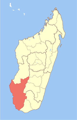
Atsimo-Andrefana is a region of Madagascar. It borders Menabe in north, Amoron'i Mania and Haute Matsiatra in northeast, Ihorombe and Anosy in east and Androy in southeast. The capital is Toliara and the population was 1,799,088 in 2018. Atsimo Andrefana is geographically the largest of all Malagasy regions with an area of 66,236 km2 (25,574 sq mi).

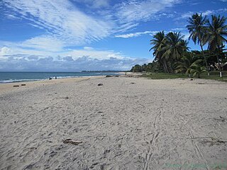
Mahanoro is a rural municipality located in the Atsinanana region of eastern Madagascar, along the coast.
Marolambo is a village and commune (kaominina) located in the Atsinanana region of eastern Madagascar. It is along the Nosivolo River near the junction with the Sandranamby River, and is also the capital of the Marolambo District.

Route nationale 2 (RN2) is a primary highway in Madagascar. The route runs from the capital city of Antananarivo to Toamasina, a city on the eastern coast of the Madagascar.

Andevoranto[andevʷˈrantʷ] is a rural municipality in the Brickaville District, Atsinanana Region, Madagascar.

Marolambo is a district of Atsinanana in Madagascar.

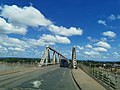
Brickaville District is an administrative district in Atsinanana Region, Madagascar; also known as Ampasimanolotra and Vohibinany. Brickaville is located along Route nationale 2, 105 km south of Toamasina and 220 km east of Antananarivo. It is also situated alongside the Rianila river. It is a railway station on the Antananarivo - East Coast line. Its main industries revolve around sugar.
Route nationale 11a is a secondary highway in Madagascar of 204 km, running from Antsampanana to Mahanoro, to the Mangoro River. It crosses the region of Atsinanana.
Ilaka Est is a rural municipality located in the Atsinanana region of eastern Madagascar, and belongs to the Vatomandry (district).