
Augsburg is a city in the Bavarian part of Swabia, Germany, around 50 kilometres (31 mi) west of the Bavarian capital Munich. It is a university town and the regional seat of the Regierungsbezirk Swabia with a well preserved Altstadt. Augsburg is an urban district and home to the institutions of the Landkreis Augsburg. It is the third-largest city in Bavaria, with a population of 304,000 and 885,000 in its metropolitan area.
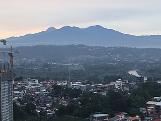
Mount Apo, also known locally as Apo Sandawa, is a large solfataric, dormant stratovolcano on the island of Mindanao, Philippines. With an elevation of 2,954 meters (9,692 ft) above sea level, it is the highest-mountain in the Philippine Archipelago, Mindanao and 24th-highest peak of an island on Earth. Located on the tripartite border of Davao City and Davao del Sur in the Davao Region, and Cotabato in Soccsksargen, Mount Apo is the most-prominent mountain in the Philippines. The peak overlooks from Davao City 45 kilometers (28 mi) to the northeast, Digos 25 kilometers (16 mi) to the southeast, and Kidapawan 20 kilometers (12 mi) to the west. It is a protected area and a Natural Park of the Philippines.

The Kura is an east-flowing river south of the Greater Caucasus Mountains which drains the southern slopes of the Greater Caucasus east into the Caspian Sea. It also drains the north side of the Lesser Caucasus, while its main tributary, the Aras, drains the south side of those mountains. Starting in northeastern Turkey, the Kura flows through Turkey to Georgia, then to Azerbaijan, where it receives the Aras as a right tributary, and enters the Caspian Sea at Neftçala. The total length of the river is 1,515 kilometres (941 mi).
A buffer zone is a neutral zonal area that lies between two or more bodies of land, usually pertaining to countries. Depending on the type of buffer zone, it may serve to separate regions or conjoin them. Common types of buffer zones are demilitarized zones, border zones and certain restrictive easement zones and green belts. Such zones may be comprised by a sovereign state, forming a buffer state.

Namhansanseong (Korean: 남한산성) is a historic Korean fortress city in Gwangju, Gyeonggi Province, South Korea. A UNESCO World Heritage Site, the fortress lies atop the mountain Namhansan and stretches 12 km in length. It served as an emergency capital city during the 1392–1910 Joseon period. The design is based on fortress architecture of East Asia, embodying aspects of four historical cultural styles: the Joseon of Korea, the Azuchi-Momoyama Period of Japan, and Ming and Qing China.

Poděbrady is a spa town in Nymburk District in the Central Bohemian Region of the Czech Republic. It has about 15,000 inhabitants. It lies on the Elbe River. The historic town centre is well preserved and is protected by law as an urban monument zone.

Southampton Common is a large open space to the north of the city centre of Southampton, England. It is bounded by the districts of Shirley, Bassett, Highfield and Portswood. The area supports a large variety of wildlife, including one of the largest populations in Britain of the nationally rare great crested newt. The Common is used for community events, Flower Festival, Race for life Cancer Research UK and formerly 'Power in the Park' hosted by Power FM.

The Historic Centre of Macao is a collection of over twenty locations that witness the unique assimilation and co-existence of Chinese and Portuguese cultures in Macau, a former Portuguese colony. It represents the architectural legacies of the city's cultural heritage, including monuments such as urban squares, streetscapes, churches and temples.
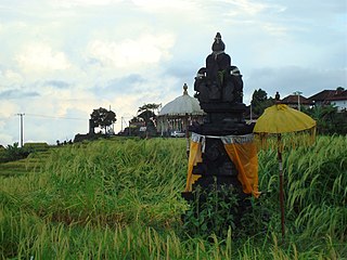
Subak is the water management (irrigation) system for the paddy fields on Bali island, Indonesia. It was developed in the 9th century. For the Balinese, irrigation is not simply providing water for the plant's roots, but water is used to construct a complex, pulsed artificial ecosystem that is at the same time autonomous and interdependent. The system consists of five terraced rice fields and water temples covering nearly 20,000 hectares. The temples are the main focus of this cooperative water management, known as subak.

The Historic Villages of Shirakawa-gō and Gokayama are one of Japan's UNESCO World Heritage Sites. The cultural property consists of three historic mountain villages over an area of 68 hectares in the remote Shogawa river valley, stretching across the border of Gifu and Toyama Prefectures in central Japan. Shirakawa-gō is located in the village of Shirakawa in Gifu Prefecture. The Gokayama area is divided between the former villages of Kamitaira and Taira in Nanto, Toyama Prefecture.
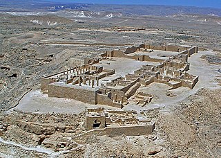
Incense Route – Desert Cities in the Negev is a World Heritage-designated area near the end of the Incense Route in the Negev, southern Israel, which connected Arabia to the Mediterranean in the Hellenistic-Roman period, proclaimed as being of outstanding universal value by UNESCO in 2005. The trade led to the development of ancient towns, forts and caravanserai en route, apart from agricultural development.

The Bethlehem Waterworks, also known as the Old Waterworks or 1762 Waterworks, is believed to be the oldest pump-powered public water supply in what is now the United States. The pumphouse, which includes original and replica equipment, is located in the Colonial Industrial Quarter of Bethlehem, Pennsylvania, between Monocacy Creek and Main Street. It was declared a National Historic Civil Engineering Landmark in 1971, an American Water Landmark in 1971, and a National Historic Landmark in 1981.
The Philippines' water supply system dates back to 1946, after the country declared independence. Government agencies, local institutions, non-government organizations, and other corporations are primarily in charge of the operation and administration of water supply and sanitation in the country.
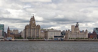
Liverpool Maritime Mercantile City is a former UNESCO designated World Heritage Site in Liverpool, England, that comprised six locations in the city centre including the Pier Head, Albert Dock and William Brown Street, and many of the city's most famous landmarks.

The Historic Centre of the City of Salzburg, also known as the Altstadt, is a district of Salzburg, Austria, recognized as UNESCO World Heritage Site since 1996. It corresponds with the historic city center, situated on the left and right banks of the Salzach river.

The Tai Tam Waterworks Heritage Trail is a heritage trail in Hong Kong that comprises 22 waterworks structures with historical value near the Tai Tam group of reservoirs. The Trail is about 5 km long and takes about two hours to complete. The Trail is located along the Tai Tam Reservoir Road with entrance at Wong Nai Chung Gap near Hong Kong Parkview or at the junction of Tai Tam Road and Tai Tam Reservoir Road. Ten information stations were established en route to introduce the functions and historic values of the structures. Guided tours will be organised for schools and non-profit making organisations.
The Cape Winelands Biosphere Reserve is located in the Western Cape Province of South Africa approximately 40 km (25 mi) east of Cape Town. The Biosphere Reserve extends from the Kogelberg Biosphere Reserve in the south, northwards along the Cape Fold Belt Mountain Chain and the adjoining valleys constituting the Cape Winelands. The Biosphere Reserve incorporates key portions of the registered Cape Floral Region Protected Areas World Heritage Site. The Reserve was designated in 2007.

The Angat Watershed Forest Reserve is a conservation area that protects the drainage basin in the southern Sierra Madre range north of Metro Manila in the Philippines where surface water empties into the Angat River and its distributaries. It is spread over an area of 62,309 hectares in the eastern portion of Bulacan and northern Rizal province at an altitude of between 490 and 1,206 metres. The conservation area also extends to the provinces of Nueva Ecija and Quezon and is centered on an artificial lake created by the Angat Dam which, together with the Ipo Dam located 7.5 kilometres (4.7 mi) downstream, supply 97% of the water requirement of Metro Manila via an aqueduct system to the La Mesa Dam and Reservoir and the Balara Filtration Plant in Quezon City. The Angat Dam and Reservoir is also a major source of hydroelectricity for Metro Manila and surrounding provinces, contributing some 200 megawatts to the Luzon grid. The watershed is a popular birdwatching site and is a biodiversity hotspot containing most of the remaining closed-canopy forests in Central Luzon.

