Communications in the Solomon Islands.

Solomon Islands is a country consisting of six major islands and over 900 smaller islands in Melanesia, part of Oceania, to the northeast of Australia. It is directly adjacent to Papua New Guinea to the northwest, Australia to the southwest, New Caledonia and Vanuatu to the southeast, Fiji, Wallis and Futuna, and Tuvalu to the east, and Nauru and the Federated States of Micronesia to the north. It has a total area of 29,000 square kilometres, and a population of approximately 700,000. Its capital, Honiara, is located on the largest island, Guadalcanal. The country takes its name from the wider area of the Solomon Islands (archipelago), which is a collection of Melanesian islands that also includes the Autonomous Region of Bougainville, but excludes the Santa Cruz Islands.

Solomon Islands is divided into nine provinces. The national capital, Honiara, on the island of Guadalcanal, is separately governed as the country's Capital Territory.

Malaita is the primary island of Malaita Province in Solomon Islands. Malaita is the most populous island of the Solomon Islands, with a population of 161,832 as of 2021, or more than a third of the entire national population. It is also the second largest island in the country by area, after Guadalcanal.
Lau Lagoon is a part of the Solomon Islands. It is located on the northeast coast of Malaita Island. The lagoon is more than 35 kilometers long and contains about 60 artificial islands built on the reef.

Laulasi island is an artificial island in the Langa Langa Lagoon, South of Auki on the island of Malaita in the Solomon Islands. It is believed that hostilities among the inlanders of Malaita forced some people into the lagoon where over time they built their islands on sandbars after diving for coral. The religion of the island was based on prayers and offerings to the ghosts of dead ancestors, mediated by priests who kept their skulls and relics in tabu houses. Some ancestors were incarnated as sharks which protected their descendants. Langalanga is also the main source of the shell money now made in Solomon Islands.

Langa Langa Lagoon or Akwalaafu is a natural lagoon on the West coast of Malaita near the provincial capital Auki within the Solomon Islands. The lagoon is 21 km in length and just under 1 km wide. The "lagoon people" or "salt water people" live on small artificial islands built up on sand bars over time where they were forced to flee from the headhunters of mainland Malaita.
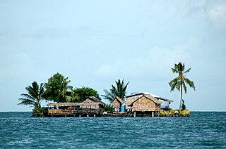
Adagege, alternatively spelled Ada Gege or Ada-gege, is an artificial island built on the reef in the Lau Lagoon on Malaita in the Solomon Islands; it is located in Malaita Province. The road from Auki ends at Fouia wharf opposite the islands of Sulufou and Adaege in the Lau Lagoon.
Sulufou is an artificial island built on the reef in the Lau Lagoon on Malaita in the Solomon Islands; it is located in Malaita Province. The road from Auki ends at Fouia wharf opposite the islands of Sulufou and Adaege in the Lau Lagoon.

Honiara is the capital and largest city of Solomon Islands, situated on the northwestern coast of Guadalcanal. As of 2021, it had a population of 92,344 people. The city is served by Honiara International Airport and the seaport of Point Cruz, and lies along the Kukum Highway.
Correctional Services of Solomon Islands (CSSI) is the correctional agency of the government of the Solomon Islands. It was previously known as the Solomon Islands Prison Service (SIPS).

The Royal Solomon Islands Police Force (RSIPF) is the national police force of Solomon Islands and in January 2015 had an establishment of approximately 1,153 officers and 43 police stations across the country.
Chinatown is a suburb of Honiara, Solomon Islands, located southeast of the main center.
Bahai Centre is a suburb of Honiara, Solomon Islands and is located west of Kukum.
NZ Camp is a suburb of Honiara, Solomon Islands and is located South-East of Honiara International Airport.
Henderson East is a suburb of Honiara, Solomon Islands and is located East of Honiara International Airport.
Malu'u is a village on the north coast of Malaita island in the Solomon Islands. The seat of the sub provincial area, it lies on Suafa Bay, within Malaita Province, along the road between Auki and Lau Lagoon.

On 5 June 2000, a coup d'état occurred in Solomon Islands, in the capital of Honiara, in which the prime minister, Bartholomew Ulufa’alu, was taken hostage by militants of the Malaita Eagle Force. The event came as a result of longstanding ethnic tensions between the province that saw a rise in armed political groups from the late 1990s.

The Coral reefs of the Solomon Islands consists of six major islands and over 986 smaller islands, in Oceania, to the east of Papua New Guinea and northwest of Vanuatu. The Solomon Islands lie between latitudes 5° and 13°S, and longitudes 155° and 169°E. The distance between the westernmost and easternmost islands is about 1,500 km (930 mi). The Santa Cruz Islands are situated north of Vanuatu and are especially isolated at more than 200 km (120 mi) from the other islands. The Solomon Islands has the 22nd largest Exclusive Economic Zone of 1,589,477 km2 (613,701 sq mi) of the Pacific Ocean.


