
Wakefield is a village in the town of South Kingstown, Rhode Island, United States, and the commercial center of South Kingstown. Together with the village of Peace Dale, it is treated by the U.S. Census as a component of the census-designated place identified as Wakefield-Peacedale, Rhode Island. West Kingston, another South Kingstown village, was the traditional county seat of Washington County. Since 1991, the Washington County Courthouse has been in Wakefield. The Sheriff's Office which handles corrections is also in Wakefield.

Saunderstown is a small village and historic district in the towns of Narragansett and North Kingstown in Washington County, Rhode Island, United States. Saunderstown has its own post office with the ZIP Code of 02874, which also includes a small part of South Kingstown. Its population is 6,245.

The Mechanic Street Historic District encompasses a historic 19th-century mill and mill village in a 14-block area of the Pawcatuck section of Stonington, Connecticut. Extending along the Pawcatuck River and south of West Broad Street, the area includes a large brick mill complex on the banks of the river, and a neighborhood of well-preserved worker housing on the road grid to its west. The district was listed on the National Register of Historic Places in 1988.
Carolina is a village that straddles the border of the towns of Charlestown and Richmond on the Pawcatuck River in Washington County, Rhode Island. Rhode Island Route 112 passes through the village. Carolina is identified as a census-designated place, with a population of 970 at the 2010 census.

The Osborn–Bennett Historic District is a residential historic district in Tiverton, Rhode Island consisting of four houses. The district was added to the National Register of Historic Places in 2006.

The Wanskuck Historic District is a historic district in the city of Providence, Rhode Island encompassing a mill village with more than two hundred years of history. As early as the mid-18th century, mills stood on the West River in northern Providence, a development which continued with the rise of industrialization in the 19th century. The mill village of Wanskuck is organized around three thoroughfares: Branch Street, Veazie Street, and Woodward Road, and is roughly bounded on the east by Louisquisset Pike and to the northwest by the city line with North Providence. The West River runs through the district, with its banks lined by two late-19th-century mill complexes. The village area includes a variety of examples of mill worker housing, from duplexes to rowhouses, as well as two church complexes and a community hall built in 1884 by the Wanskuck Company.

The Wayland Historic District is a predominantly residential historic district on the east side of Providence, Rhode Island. It is a large area, covering about 122 acres (49 ha), bounded roughly on the north by Everett and Laurel Avenues, on the east by Blackstone Boulevard and Butler Avenue, on the west by Arlington Avenue, and on the south by Angell and South Angell Streets. This area, which was in the 19th century part of the Moses Brown farm, was platted for development in 1891, with most of the construction taking place in the early decades of the 20th century. Most of the residential properties in the district are single-family houses, typically built in revival styles popular at the time. They are set on similarly sized lots with fairly uniform setbacks, and were typically built without garages. There are a number of two-family houses, and a small number of apartment buildings, most of which are found on the arterial roads of the area. There are several religious buildings, including several churches; the most architecturally distinctive religious building is the Jewish Temple Beth El, built 1951–54.
Black Farm, also known as the Isaac Collins Farm, is a historic farm in Hopkinton, Rhode Island bounded by Woodville Alton Road and Wood Road. The 264-acre (107 ha) plot was developed by John Collins beginning in 1710 and saw agricultural use for over 200 years. The main house dates to the late 18th century, and is a 1-1/2 story gambrel-roofed post-and-beam structure. Outbuildings include 19th century barns, a corn crib, and a guest cottage added in the 1930s. Set some distance off from this complex is the foundational remains of what was probably an ice house; it consists of granite blocks and is eight feet high.

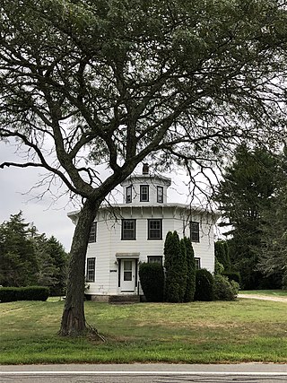
The Henry Eldred Farm is an historic farm complex at 368 Old North Road in South Kingstown, Rhode Island. The main block of the farmhouse, a 2+1⁄2-story wood-frame structure, was probably built c. 1822, although there is architectural evidence suggesting it may be an enlargement of an older structure. Its simple Federal styling is distinctly rural and vernacular in character. The complex also includes a cluster of buildings dating to the mid-19th century, including a barn, carriage house, shed, and blacksmith shop.

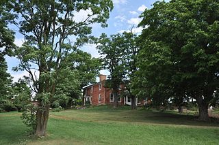
The Joseph Pierce Farm is an historic farm at 933 Gilbert Stuart Road in North Kingstown, Rhode Island. It consists of 18 acres (7.3 ha) of land, along with an 18th-century farmhouse and a number of 19th-century outbuildings. The oldest portion of the house, its southern ell, was originally built with a gable roof, but this was extended to the north in the late 18th or early 19th century, and given it present gambrel roof and Federal styling. Later additions in the 19th and 20th centuries gave the house its present cruciform appearance. Outbuildings dating to the 19th century include a barn with attached privy, a toolshed, and a henhouse. The complex is a well-preserved reminder of the area's rural heritage.

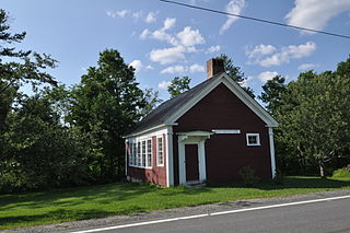
The Shady Lea Historic District is a historic district on Shady Lea and Tower Hill Roads in North Kingstown, Rhode Island. It encompasses a predominantly residential linear district extending along Shady Lea Road southward from Tower Hill Road. Most of the houses along Shady Lea Road are mill worker housing built in the 19th century for workers at the mill complex which stands at the edge of the Shady Lea Mill Pond, at the southern end of the district. This area is a well-preserved example of the numerous rural mill complexes which dotted the Rhode Island countryside in the 19th century.

Wyoming is a village and census-designated place on the Wood River in southern Rhode Island, primarily in the town of Richmond, Rhode Island, but extending north across the river into the town of Hopkinton, Rhode Island. The population was 270 at the 2010 census. It is the site of the Wyoming Village Historic District and a post office assigned ZIP code 02898.

The Parker Hill Rural Historic District encompasses a large rural agricultural landscape in eastern Windham and Windsor counties in the US state of Vermont. Roughly centered on Parker Hill Road in northern Rockingham and southern Springfield, the district exhibits a history of 200 years of farming, including a collection of Federal period farm housing. The district was listed on the National Register of Historic Places in 1993.
The Jericho Rural Historic District encompasses a rural agricultural landscape of northern Hartford, Vermont, extending slightly into neighboring Norwich. The area covers 774 acres (313 ha) of mainly agricultural and formerly agricultural lands, as well as associated woodlots, and includes nine historically significant farm complexes. It was listed on the National Register of Historic Places in 2001.

The South Newbury Village Historic District encompasses the surviving elements of a small industrial village in southern Newbury, Vermont. It includes five residences and several outbuildings, most of which are agricultural in character, representing the area's shift in use in the 20th century. The district was listed on the National Register of Historic Places in 1983.
The Colonel Ephraim and Sarah Doolittle Farm is a historic farm property on Doolittle Road in Shoreham, Vermont. It is one of the oldest colonial farm properties in western Vermont, established in 1766 by Colonel Ephraim Doolittle, a veteran of the French and Indian War and the American Revolutionary War. It was listed on the National Register of Historic Places in 1995.
The Dan Johnson Farmstead is a historic farm property on United States Route 2 in Williston, Vermont. It was first developed in 1787 by Dan Johnson, one of Williston's first settlers, and has remained in his family since that time. The property includes three 19th-century houses and a large barn complex, as well as more than 200 acres (81 ha) of land crossed by US 2 and Interstate 89. It was listed on the National Register of Historic Places in 1993.

The M.S. Whitcomb Farm is a historic farm property on United States Route 2 in Richmond, Vermont. Established in the 1850s as a horse farm, it has seen agricultural use in some form since then. Its most distinguishing feature is a large bank barn with a monitor roof, built in 1901. The property, now 170 acres (69 ha), was listed on the National Register of Historic Places in 1993.

The Windsor Farms Historic District encompasses a large historically agricultural area and the historic town center of South Windsor, Connecticut. Its built environment extends mainly along Main Street, between Interstate 291 in the south and Strong Road in the north, with a diversity of architecture spanning three centuries. The district includes agricultural fields on both sides, many of which remain in tobacco cultivation. The district was listed on the National Register of Historic Places in 1986.

Guilford Historic Town Center is a large historic district encompassing the entire town center of Guilford, Connecticut, in the United States. It is centered on the town green, laid out in 1639, and extends north to Interstate 95, south to Long Island Sound, west to the West River, and east to East Creek. It includes more than 600 historic structures, most built between the late 17th and early 20th centuries, reflecting the town's growth and history during that time. It was listed on the National Register of Historic Places in 1976.


