
Hydrography is the branch of applied sciences which deals with the measurement and description of the physical features of oceans, seas, coastal areas, lakes and rivers, as well as with the prediction of their change over time, for the primary purpose of safety of navigation and in support of all other marine activities, including economic development, security and defense, scientific research, and environmental protection.

Hydrographic survey is the science of measurement and description of features which affect maritime navigation, marine construction, dredging, offshore oil exploration/offshore oil drilling and related activities. Strong emphasis is placed on soundings, shorelines, tides, currents, seabed and submerged obstructions that relate to the previously mentioned activities. The term hydrography is used synonymously to describe maritime cartography, which in the final stages of the hydrographic process uses the raw data collected through hydrographic survey into information usable by the end user.
Australasian is the adjectival form of Australasia, a geographical region including Australia, New Zealand, and New Guinea.

The Australasian realm is a biogeographic realm that is coincident with, but not the same as, the geographical region of Australasia. The realm includes Australia, the island of New Guinea, and the eastern part of the Indonesian archipelago, including the island of Sulawesi, the Moluccan islands, and the islands of Lombok, Sumbawa, Sumba, Flores, and Timor, often known as the Lesser Sundas.
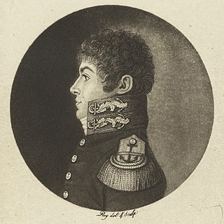
Louis Claude de Saulces de Freycinet was a French Navy officer. He circumnavigated the earth, and in 1811 published the first map to show a full outline of the coastline of Australia.
APRA AMCOS consists of Australasian Performing Right Association (APRA) and Australasian Mechanical Copyright Owners Society (AMCOS), both copyright management organisations or copyright collectives which jointly represent over 100,000 songwriters, composers and music publishers in Australia and New Zealand. The two organisations work together to license public performances and administer performance, communication and reproduction rights on behalf of their members, who are creators of musical works, aiming to ensure fair payments to members and to defend their rights under the Australian Copyright Act (1968).
Corrosion societies are professional societies for corrosion engineers for the purpose of sharing experience and discoveries.
The Baudin expedition of 1800 to 1803 was a French expedition to map the coast of New Holland. Nicolas Baudin was selected as leader in October 1800. The expedition started with two ships, Géographe, captained by Baudin, and Naturaliste captained by Jacques Hamelin, and was accompanied by nine zoologists and botanists, including Jean-Baptiste Leschenault de la Tour, François Péron and Charles-Alexandre Lesueur as well as the geographer Pierre Faure.
The Australasian College of Tropical Medicine (ACTM) is an Australasian medical association.
The Australasian Association of Philosophy (AAP) is the peak body for philosophy in Australasia. The chief purpose of the AAP is to promote philosophy in Australia, New Zealand, and Singapore. Among the means that it follows to achieve this end, the AAP runs an annual conference, publishes two journals, awards various prizes, sponsors postgraduate and undergraduate philosophical activities, maintains affiliations with numerous other organisations that aim to promote philosophy and philosophical activity, and promotes philosophy in schools, cafes, pubs, and everywhere else that philosophy may be found.
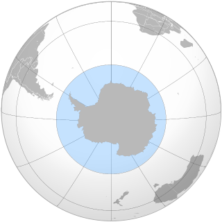
The Southern Ocean, also known as the Antarctic Ocean, comprises the southernmost waters of the World Ocean, generally taken to be south of 60° S latitude and encircling Antarctica. As such, it is regarded as the second-smallest of the five principal oceanic divisions: smaller than the Pacific, Atlantic, and Indian oceans but larger than the Arctic Ocean. Over the past 30 years, the Southern Ocean has been subject to rapid climate change, which has led to changes in the marine ecosystem.
Rear-Admiral George Stephen "Steve" Ritchie CB DSC was a British admiral noted for his cartographic and hydrographic work.
Lawn Tennis Association of Australasia (LTAA) was the tennis organisation formed after the amalgamation of New Zealand Lawn Tennis Association and six Australian state tennis associations in 1904. New Zealand split from the tennis association partnership in 1922 and hence caused dissolution of LTAA. LTAA was the founding member of the International Lawn Tennis Federation (ILTF), which was established in a conference in Paris, France on 1 March 1913.
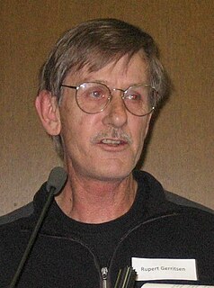
Rupert Gerritsen (RON) was an Australian historian and a noted authority on Indigenous Australian prehistory. Coupled with his work on early Australian cartography, he played an influential part in re-charting Australian history prior to its settlement by the British in 1788, and noted evidence of agriculture and settlements on the continent before the arrival of settlers.

Australia on the Map is the history and heritage division of the Australasian Hydrographic Society. It seeks to enhance Australians’ knowledge, understanding and appreciation of the nation's early history, beginning in 1606 with the voyages of Willem Janszoon in the Duyfken and Luis Váez de Torres in Los Tres Reyes and San Pedro, and continuing to the present.

The 't Gulden Zeepaert, usually referred to as the Gulden Zeepaert was a ship belonging to the Dutch East India Company (VOC). It sailed along the south coast of Australia from Cape Leeuwin in the south west of Western Australia to the Nuyts Archipelago in South Australia early in 1627.
The Freycinet Map of 1811 is the first map of Australia to be published which shows the full outline of Australia. It was drawn by Louis de Freycinet and was an outcome of the Baudin expedition to Australia. It preceded the publication of Matthew Flinders' map of Australia, Terra Australis or Australia, by three years.

The Surveying and Spatial Sciences Institute (SSSI) is the professional association for surveyors and spatial science workers, including cartography, hydrography, remote sensing, engineering and mining surveying, photogrammetry and spatial information in Australia. The Institute's members are involved in communities of practice such as land administration, land development, natural resource management, forestry, agriculture, defence, marine environment, local government, health, education, transport, tourism, and many more. The institute deals with policy, administration, collection, measurement, analysis, interpretation, portrayal and dissemination of spatially- related land and sea information, together with associated planning, design and management.
The Human Genetics Society of Australasia (HGSA) is a membership organization for individuals in the field of human genetics who primarily practise in the Oceania region. Members typically hold both a qualification in human genetics and work in the field. Membership is drawn from clinical, laboratory and academic specialties. Members include clinical geneticists; genetic counsellors; laboratory scientists ; and academics.
