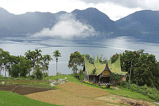
Lake Toba is a large natural lake in North Sumatra, Indonesia, occupying the caldera of the Toba supervolcano. The lake is located in the middle of the northern part of the island of Sumatra, with a surface elevation of about 900 metres (2,953 ft), the lake stretches from 2.88°N 98.52°E to 2.35°N 99.1°E. The lake is about 100 kilometres long, 30 kilometres (19 mi) wide, and up to 505 metres (1,657 ft) deep. It is the largest lake in Indonesia and the largest volcanic lake in the world. Toba Caldera is one of twenty geoparks in Indonesia, and was recognised in July 2020 as one of the UNESCO Global Geoparks.
Lake Maninjau is a caldera lake in West Sumatra, Indonesia. It is located 36 kilometres (22 mi) to the west of Bukittinggi, at 0°19′S100°12′E.

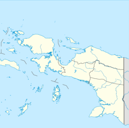
Biak is the main island of Biak Archipelago located in Cenderawasih Bay near the northern coast of Papua, an Indonesian province, and is just northwest of New Guinea. Biak has many atolls, reefs, and corals.

Lake Chapala has been Mexico's largest freshwater lake since the desiccation of Lake Texcoco in the early 17th century.

The Kapuas River is a river in the Indonesian part of Borneo island, at the geographic center of Maritime Southeast Asia. At 1,143 kilometers (710 mi) in length, it is the longest river in the island of Borneo and the longest river in Indonesia and one of the world's longest island rivers. It originates in the Müller mountain range at the center of the island and flows west into the South China Sea creating an extended marshy delta. The delta is located west-southwest of Pontianak, the capital of the West Kalimantan province. This Kapuas River should be distinguished from another Kapuas River, which starts on the other side of the same mountain range in central Borneo but flows to the south, merging with the Barito River and discharging into the Java Sea.

Lake Kutubu is the second-largest lake in Papua New Guinea, after Lake Murray, and, at 800 m above sea level, the largest upland body of water, with an area of 49.24 km², and a total catchment area of 250 km². Lake Kutubu and Lake Sentani form an ecoregion on the WWF's Global 200. Kutubu lies in the Southern Highlands Province of Papua New Guinea, east of the Kikori River into which it drains, and about 50 km southwest of Mendi, the provincial capital. It is one of the few lakes in the country that occurs in a depression in the rugged interior mountains. The lake has a few islands, the largest of which is Wasemi in its northern part. The water of Lake Kutubu, fed by several streams originating mostly from underground sources, is clear and reaches a depth of 70 m (230 feet). The catchment is inhabited by two main ethnic groups, the Foe to the south and the Fasu to the north. Thirty-three villages lie in the catchment area, with a total estimated population of 10,885.
The Ajamaru Lakes rainbowfish is a species of rainbowfish in the Melanotaeniinae subfamily. It is endemic to the Ayamaru Lakes in West Papua, Indonesia.

Boeseman's rainbowfish, also known as the Boesemani rainbowfish, is a species of fish in the family Melanotaeniidae.

The dwarf rainbowfish is a species of rainbowfish in the subfamily Melanotaeniinae. It is known under a number of common names including diamond rainbowfish, neon rainbowfish, Praecox rainbowfish, dwarf neon rainbowfish, peacock rainbowfish, and Teczanka neonowa. It is endemic to the Mamberamo River basin in West Papua in Indonesia and common in the aquarium trade.
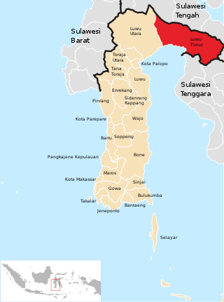
East Luwu Regency is the most easterly of the twenty-one regencies in South Sulawesi Province of Indonesia. The regency was created on 25 February 2003 by separation of the eastern districts from North Luwu Regency. It covers a land area of 6,747.93 km2. The administrative capital of the regency is the coastal town of Malili on the Bay of Usu, itself an inlet in the northeast corner of the Gulf of Bone; the town, with its port of Balantang, is the shipping port for one of the world's major nickel-producing plants. The population of the Regency was 243,069 at the 2010 Census and 296,741 at the 2020 Census; the official estimate as at mid 2023 was 313,404.
Maybrat is a Papuan language spoken in the central parts of the Bird's Head Peninsula in the Indonesian province of Southwest Papua.
The Baliem River is a river in the Highland Papua and South Papua provinces of Western New Guinea, Indonesia. It is the largest tributary of the Pulau River, formerly called the Eilanden River. With a total length of 414.2 km (257.4 mi).

The Perth Wetlands, also known as the Perth Great Lakes or the Great Lakes District, was a collection of fresh-water wetlands, swamps and lakes located on the Swan Coastal Plain north of the city of Perth in Western Australia. Over a period of 80 years from the first British settlement in Western Australia in 1829 most of the wetlands were reclaimed for use as housing, parks and market gardens.
The Paniai Lakes, originally known as the Wissel Lakes, are the three large, freshwater lakes in Central Papua, Indonesia: Paniai, Tigi, and Tage. Lakes Paniai and Tage are located in the Paniai Regency, while Lake Tigi is located in the Deiyai Regency. The largest of the three is Lake Paniai, while its immediate neighbor Lake Tage is the smallest.

Cherax holthuisi is a species of crayfish from the Bird's Head Peninsula in New Guinea. It grows to a total length of 81–93 mm (3.2–3.7 in) and is typically pink, orange or yellow in wild specimens. It was described in 2006 after animals circulating in the aquarium trade could not be assigned to any known species.

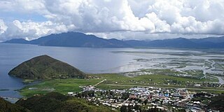
Lake Sentani is a tropical, shallow, and at low-altitude open lake located at the northeast extremity of the Jayapura Regency in the Indonesian province of Papua, about 20 kilometres (12 mi) from the provincial capital, Jayapura City. It is located just to the south of the town of Sentani.
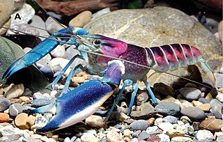
Cherax pulcher is a species of crayfish from West Papua in Indonesia. It is popular as a freshwater aquarium species across Asia, Europe, and North America.
MV Sinar Bangun sank on 18 June 2018 in Lake Toba, North Sumatra, Indonesia, during its trip from Simanindo Harbour in Samosir Island to Tiga Ras Harbour in Simalungun Regency. The ferry was carrying 188 passengers and crew. After the sinking, authorities immediately deployed search and rescue personnel to the area. Twenty-one survivors were rescued, three bodies were found and 164 people were listed as missing and presumed dead.

Southwest Papua is the 38th province of Indonesia to be created, and was split off from West Papua on 8 December 2022. Despite being named southwest, it is a misnomer and this province is actually located in the northwest edge of Papua. The province comprises the Greater Sorong area which consists of Sorong City, Sorong Regency, South Sorong Regency, Maybrat Regency, Tambrauw Regency, and Raja Ampat Regency. The Bill (RUU) on the Establishment of the Southwest Papua Province was passed into law and therefore it became the 38th province in Indonesia with effect from 8 December 2022.
The Bird's Neck Isthmus is an isthmus in western New Guinea. It connects the main mass of the island to its two large western peninsulas, the Bird's Head Peninsula, also known as the Vogelkop or Doberai Peninsula, and the Bomberai Peninsula. The isthmus is mostly covered in lowland tropical rain forest.