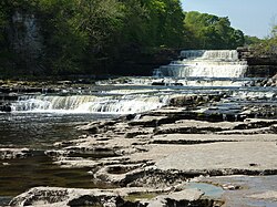
Aysgarth Falls

Last updated

Aysgarth Falls
Aysgarth High Force.JPG
The Upper Falls seen from the bridge
Aysgarth Falls
LocationAysgarth, North Yorkshire
Coordinates 54°17′37.09″N1°58′56.00″W / 54.2936361°N 1.9822222°W / 54.2936361; -1.9822222
Number of drops3
Run 200 feet (61 m)
Watercourse River Ure
The Middle Falls from the North bank Aysgarth Middle Force.JPG
The Middle Falls from the North bank
The Lower Falls from the riverside Aysgarth Lower Force.JPG
The Lower Falls from the riverside

Aysgarth Falls are a triple flight of waterfalls, [1] surrounded by woodland and farmland, carved out by the River Ure over an almost one-mile (two-kilometre) stretch on its descent to mid-Wensleydale in the Yorkshire Dales of England, near the village of Aysgarth. The falls are quite spectacular after heavy rainfall as thousands of gallons of water cascade over the series of broad limestone steps, which are divided into three stages: Upper Force, Middle Force and Lower Force. [2]

Contents

The falls are an SSSI. [3]

Description

Aysgarth Falls have attracted visitors for more than 200 years, including John Ruskin, J. M. W. Turner and William Wordsworth [4] visited, all enthusing about the falls' outstanding beauty. [5] The falls were created when meltwater from the Ice-Age that had been held back by a terminal moraine, spilled down over the area and eroded the boulder clay and into the bedrock limestone underneath. [6] [7] The falls drop 200 feet (61 m) over a half-mile section of the river. [8]

The Falls are situated in the Yorkshire Dales National Park. There is a visitors' centre with an exhibition, information, items for sale, a café, toilets and a pay-and-display car park. [9]

There are public footpaths through the wooded valley, offering views of the river and falls. [10] Wild flowers appear in the spring and summer, for example snowdrops in January and February, primroses in April and bluebells in May, and birds, squirrels and deer may also be seen. Occasionally salmon can be seen leaping up the falls in autumn. Nearby is St Andrew's Church, which has what is reputed to be the largest churchyard in England. The church has a medieval painted wooden screen rescued from the destroyed Jervaulx Abbey. [11]

The name originates from Old Norse and means the open space in the oak trees. [12]

All three falls were featured in the films Robin Hood: Prince of Thieves and Emily Brontë's Wuthering Heights, [13] [14] and they were featured on the television programme Seven Natural Wonders as one of the wonders of the North. [15]

See also

Related Research Articles

<span class="mw-page-title-main">Wharfedale</span> Valley in Yorkshire, England

Wharfedale is the valley of the upper parts of the River Wharfe and one of the Yorkshire Dales. It is situated in North Yorkshire, and the cities of Leeds and Bradford in West Yorkshire. It is the upper valley of the River Wharfe. Towns and villages in Wharfedale include Buckden, Kettlewell, Conistone, Grassington, Hebden, Bolton Abbey, Addingham, Ilkley, Burley-in-Wharfedale, Otley, Pool-in-Wharfedale, Arthington, Collingham and Wetherby. Beyond Wetherby, the valley opens out and becomes part of the Vale of York.

<span class="mw-page-title-main">Yorkshire Dales</span> Upland area of the Pennines in Northern England

The Yorkshire Dales is an upland area of the Pennines in the historic county of Yorkshire, England, most of it in the Yorkshire Dales National Park created in 1954.

<span class="mw-page-title-main">Wensleydale</span> Upper valley of the River Ure in North Yorkshire, England

Wensleydale is the dale or upper valley of the River Ure on the east side of the Pennines, one of the Yorkshire Dales in North Yorkshire, England.

<span class="mw-page-title-main">Yorkshire Dales National Park</span> National park in England

The Yorkshire Dales National Park is a 2,178 km2 (841 sq mi) national park in England covering most of the Yorkshire Dales, with the notable exception of Nidderdale. Most of the park is in North Yorkshire, with a sizeable area in Cumbria and a small part in Lancashire. The park was designated in 1954, and extended in 2016. Over 95% of the land in the Park is under private ownership; there are over 1,000 farms in this area.

<span class="mw-page-title-main">Grassington</span> Village and civil parish in North Yorkshire, England

Grassington is a village and civil parish in North Yorkshire, England. The population of the parish at the 2011 Census was 1,126. Historically part of the West Riding of Yorkshire, the village is situated in Wharfedale, about 8 miles (10 km) north-west from Bolton Abbey, and is surrounded by limestone scenery. Nearby villages include Linton, Threshfield, Hebden, Conistone and Kilnsey.

<span class="mw-page-title-main">Hawes</span> Market town and civil parish in North Yorkshire, England

Hawes is a market town and civil parish in North Yorkshire, England, at the head of Wensleydale in the Yorkshire Dales, and historically in the North Riding of Yorkshire. The River Ure north of the town is a tourist attraction in the Yorkshire Dales National Park.

<span class="mw-page-title-main">Hardraw Force</span> Waterfall in North Yorkshire, England

Hardraw Force is a waterfall on Hardraw Beck in Hardraw Scar, a wooded ravine just outside the hamlet of Hardraw, 0.9 miles (1.5 km) north of the town of Hawes, Wensleydale, in the Yorkshire Dales. The Pennine Way long distance footpath passes close by.

<span class="mw-page-title-main">Aysgarth</span> Village and civil parish in North Yorkshire, England

Aysgarth is a village and civil parish in Wensleydale, in the Richmondshire district of North Yorkshire, England. The village is in the Yorkshire Dales National Park, about 16 miles (26 km) south-west of Richmond and 22.6 miles (36.4 km) west of the county town of Northallerton.

<span class="mw-page-title-main">Gayle, North Yorkshire</span> Hamlet in North Yorkshire, England

Gayle is a hamlet sited 0.4-mile (0.64 km) south of Hawes in Wensleydale, North Yorkshire, England. The hamlet is noted for the beck that flows through it and the old mill, which featured on the BBC programme Restoration.

<span class="mw-page-title-main">Kisdon Force</span> Waterfall in North Yorkshire, England

Kisdon Force is a series of waterfalls on the River Swale in Swaledale, England. The falls are situated within the Yorkshire Dales National Park in the county of North Yorkshire, 500 metres downstream from the small hamlet of Keld at grid reference NY898010.

<span class="mw-page-title-main">Appersett</span> Hamlet in Wensleydale, North Yorkshire, England

Appersett is a hamlet in the Yorkshire Dales in the Richmondshire district of North Yorkshire, England one mile (1.6 km) west of Hawes. It lies on the A684 road and an unclassified road runs alongside Widdale Beck to connect with the B6255 road between Hawes and Ingleton.

<span class="mw-page-title-main">West Burton, North Yorkshire</span> Village in North Yorkshire, England

West Burton is a village in Bishopdale, a side valley of Wensleydale, in the Yorkshire Dales, North Yorkshire, England. It lies 6.2 miles (10 km) south-west of Leyburn and 22.3 miles (35.9 km) west of the county town of Northallerton. It is the largest settlement in the civil parish of Burton-cum-Walden.

<span class="mw-page-title-main">Burtersett</span> Village in North Yorkshire, England

Burtersett is a small village in the Yorkshire Dales, North Yorkshire, England. It lies approximately 1 mile (1.6 km) east from Hawes and Gayle. The village is known for its former quarrying industry and being the seat of the Hillary family, with one strand of the family emigrating to New Zealand and raising Sir Edmund Hillary, the famous mountaineer.

<span class="mw-page-title-main">Coverdale (dale)</span> Valley of the Yorkshire Dales, England

Coverdale is a dale in the far east of the Yorkshire Dales, North Yorkshire, England. It takes its name from the River Cover, a tributary of the River Ure. The dale runs south-west from the eastern end of Wensleydale to the dale head at a pass, known as Park Rash Pass, between Great Whernside to the south and Buckden Pike to the north. It is accessible by a single track road, which runs the length of the dale and over the pass to Kettlewell in Wharfedale. The name is taken from that of the River Cover, which is of Brittonic origin. Ekwall suggested that it might mean "hollow stream", but more recently Andrew Breeze has argued that it is cognate with Welsh gofer "streamlet".

<span class="mw-page-title-main">Dentdale</span> Valley in Cumbria, England

Dentdale is a dale or valley in the north-west of the Yorkshire Dales National Park in Cumbria, England. It is the valley of the River Dee, but takes its name from the village of Dent. The dale runs east to west, starting at Dent Head, which is the location of a railway viaduct on the Settle-Carlisle Line.

<span class="mw-page-title-main">Cotter Force</span> Waterfall in North Yorkshire, England

Cotter Force is a small waterfall on Cotterdale Beck, a minor tributary of the River Ure, near the mouth of Cotterdale, a side dale in Wensleydale, North Yorkshire, England.

<span class="mw-page-title-main">Bishopdale Beck</span> Stream in North Yorkshire, England

Bishopdale Beck is a major tributary of the River Ure in North Yorkshire, England. The beck flows down Bishopdale, a side valley of Wensleydale in the Yorkshire Dales.

<span class="mw-page-title-main">Stainforth Force</span> Waterfall in North Yorkshire, England

Stainforth Force, is a 2.5-metre high cascade waterfall on the River Ribble at Stainforth, 3 miles (5 km) north of Settle in North Yorkshire, England. The waterfall is a popular tourist attraction in autumn when salmon are migrating up the river.

<span class="mw-page-title-main">Cauldron Falls (North Yorkshire)</span> Waterfall in North Yorkshire, England

Cauldron Falls, is a series of waterfalls on Walden Beck in the village of West Burton, North Yorkshire, England. It is known as Cauldron Falls due to the swirls in the plunge pools beneath the cascades of the waterfall. The beck continues on underneath a packhorse bridge where there is another cascade.

<span class="mw-page-title-main">Chapel-le-Dale (valley)</span> Valley in the Yorkshire Dales, England

Chapel-le-Dale is west-facing valley in the Yorkshire Dales, England. The U-shaped valley of Chapel-le-Dale is one of the few which drain westwards towards the Irish Sea, however, the river that flows through the valley has several names with the Environment Agency and the Ordnance Survey listing it as the River Doe. However, some older texts insist the name of the watercourse through the dale is the River Greta, which runs from a point below the hamlet of Chapel-le-Dale, and onwards past Ingleton. The dale is sparsely populated with only one settlement, the hamlet of Chapel-le-Dale, which has a small chapel.

References

  1. "Wensleydale Yorkshire History". englandsnortheast.co.uk. Retrieved 9 February 2020.
  2. Fellows, Griffith (2003). The waterfalls of England : a guide to the best 200. Wilmslow: Sigma Leisure. p. 136. ISBN   1-85058-767-1.
  3. "Aysgarth SSSI". designatedsites.naturalengland.org.uk. Retrieved 9 February 2020.
  4. "Aysgarth Falls". Yorkshire Dales National Park Authority. Retrieved 9 February 2020.
  5. Hill, Daniel; Warburton, Stanley (1980). Turner in Yorkshire. York: York City Art Gallery. p. 79. ISBN   0950325015.
  6. Wright, Geoffrey (1986). The Yorkshire Dales. Newton Abbot: David & Charles. p. 27. ISBN   0-7153-8702-2.
  7. Waltham, Tony (2007). The Yorkshire Dales: landscape and geology. Ramsbury: Crowood press. p. 95. ISBN   9781861269720.
  8. Bagshaw, Mike (2019) [2014]. Slow travel Yorkshire Dales (2 ed.). Chalfont St Peter: Bradt. p. 140. ISBN   978-1-78477-609-1.
  9. "Aysgarth Falls". yorkshiredales.org.uk. Retrieved 14 July 2023.
  10. "Walks around Aysgarth Falls". Walks in Yorkshire. Retrieved 13 September 2017.
  11. "St Andrew's, Aysgarth". A Church Near You. Retrieved 6 January 2016.
  12. "Aysgarth and Aysgarth Falls". Yorkshire Dales trail. Archived from the original on 28 January 2016. Retrieved 6 January 2016.
  13. "Filming locations in Yorkshire". Yorkshire.com. Archived from the original on 25 October 2016. Retrieved 25 October 2016.
  14. "Filming in the Yorkshire Dales". yorkshiredales.org.uk. Retrieved 14 July 2023.
  15. "BBC - Seven Wonders - Aysgarth Falls". www.bbc.co.uk. Retrieved 6 January 2016.