Azarori | |
|---|---|
Commune and village | |
| Country | |
| Area | |
| • Total | 78.5 sq mi (203.4 km2) |
| Elevation | 1,155 ft (352 m) |
| Population (2012) | |
| • Total | 18,582 |
| • Density | 240/sq mi (91/km2) |
| Time zone | UTC+1 (WAT) |
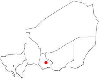
Azarori is a village and rural commune in Niger. [1]
Azarori | |
|---|---|
Commune and village | |
| Country | |
| Area | |
| • Total | 78.5 sq mi (203.4 km2) |
| Elevation | 1,155 ft (352 m) |
| Population (2012) | |
| • Total | 18,582 |
| • Density | 240/sq mi (91/km2) |
| Time zone | UTC+1 (WAT) |
Azarori is a village and rural commune in Niger. [1]
Azarori lies in the Sahel. The neighboring municipalities are Tama in the northwest, Bouza in the northeast, Madaoua in the southeast and Galma Koudawatche in the southwest. The territory is divided into seven administrative villages, nine traditional villages and 21 hamlets. The main town of the rural community is the administrative village Azarori (also: Azérori sédentaire).
At the 2001 census Azarori had 13,873 inhabitants. In the 2012 census, the population was 18,582. [2] In the community members of the live Hausa subgroup Gobirawa and the Tuareg subgroup Kel Gress.
Azarori lies in that narrow zone along the border with Nigeria , of Tounounga in the west to Malawa ranges in the east and in the irrigation field economy operated. There are millet, sorghum , cowpeas grown, peanuts, onions and lettuce. Another important economic activity is livestock farming. In the municipal area also plaster and lime are mined. Due to its proximity to the main city of Madaoua, there are only a few health and education facilities in Azarori. In education, there are eleven primary schools and a secondary school. Madaoua Azarori is connected via the National Road 16, which in the other direction to the regional capital Tahoua leads.

Tahoua is one of eight Regions of Niger. The capital of the region is the commune of Tahoua. The region covers 106,677 km².

Dakoro is a town and commune located in the Maradi Region of Niger. As of 2012, it had a population of 71,201. It is the capital of the Dakoro Department.

Madaoua is a town and urban commune located in the Tahoua Region of Niger. It has a population of 127,254. It is seat of the Madaoua Department, forming the southwest corner of the Region, and is an Urban Commune.
Mayahi is a town located in the Maradi Region of Niger. It is the seat of Mayahi Department and a Commune about 45 km from Tessaoua. In 2012 it had a population of 14,000 in the urban area. The name "Mayaki" is also a rulers' title among the Sudié and Maouri: local subgroups of the Hausa people.
Karma is a town and a rural commune in southwestern Niger, near the city of Niamey. The town had a population of 8,505 as of the 2012 census, and the commune had a population of 88,244.

Niger is divided into seven regions, each of which is named after its capital. Additionally, the national capital, Niamey, comprises a capital district.

Tanout is a department of the Zinder Region in Niger. Its administrative seat is the city of Tanout. As of 2012, the department had a total population of 429,150 people.
Akoubounou, or Akabinu in the local Tin Sert language, is a village located in the west to the town of Abalak, in the Tahoua Region of Niger.
Ansongo is a rural commune and small town in the Gao Region of eastern Mali. The town lies on the left bank of the Niger River 90 km south of Gao. It is the administrative center for the surrounding Ansongo Cercle. The commune covers an area of 445 square kilometers and in the 2009 census had a population of 32,709.
Abala, Niger is a village and rural commune in Niger.
Garhanga is a village and rural commune in Niger. It is located in the Keita Department of the Tahoua region. As of 2012, it has a population of 69,712.

Harikanassou is a large village and rural commune in the Boboye Department of the Dosso Region of southwest Niger, 90.7 kilometres (56.4 mi) by road southeast of the capital of Niamey. At the time of the 2012 census, the rural community had 23,567 residents living in 3,340 households. Onion cultivation is a chief source of income for many, along with the cultivation of lettuce, beans, squashes, and tomatoes.

Liboré is a rural commune (municipality) in the Kollo Department, Tillabéri Region, in Niger. As of 2012, it had a population of 26,243.
Tamaske is a city and rural commune in Niger. It is located in the Keita Department, in the Tahoua Region.
Tarka, Niger is a village and rural commune in Niger. It is located in the Belbédji Departement of the Zinder Region. As of 2012 the commune had a population of 96,452.

Tassara is a village and rural commune in Niger.
Tenhya is a village and rural commune in Niger. As of 2012, it had a total population of 31,057 people. Tenhya is located in the northern Sahel. The neighboring municipalities are Aderbissinat in the northwest, the northeast Tabelot, Tesker to the east and south and Tarka in the west. The rural community of Tenhya was founded in 2002 as an administrative unit. The main ethnic groups are the Fulani subgroup Wodaabe and the Tuareg subgroups Ichiriffen, Imdan, Inesseliman, Kel Ates, Kel Iferwane and Ifoghas, mainly engaged in pastoral farming.
Tondikandia is a rural commune in Filingué Department, Tillabéri Region, Niger. Its chief place and administrative center is the town of Damana.
Yaouri is a village and rural commune in Matameye Department in Niger.
Dalli (Dali) was a large town in the Zinder Region of Niger. It is now mostly abandoned ruins as the Sahara and the Sahel continue to dry up. As of 2011 census, the remaining inhabitants form three separate villages, one with 129 people (#22705), the second with 242 people (#22706), and the third with 52 people (#22894).
https://web.archive.org/web/20170109200758/http://www.stat-niger.org/statistique/file/RENACOM/RENACOM.rar https://web.archive.org/web/20150107184239/http://www.adeanet.org/triennale-followup/sites/default/files/tdrcolloqueeducation.pdf http://www.stat-niger.org/statistique/file/RGPH2012/Resultats_globaux_definitifs_RGPH2012.pdf https://web.archive.org/web/20130927005319/http://www.savethechildren.org.uk/sites/default/files/docs/Comprendre_leconomie_des_menages_ruraux_low_res_1.pdf