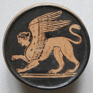
A sphinx is a mythical creature with the head of a human, the body of a lion, and the wings of an eagle.

Dâmbovița County is a county of Romania, in Muntenia, with the capital city at Târgoviște, the most important economic, political, administrative and cultural center of the county. It is a traditional administrative unit, first attested in 1512.

Prahova County is a county (județ) of Romania, in the historical region Muntenia, with the capital city at Ploiești.

Predeal is a town in Brașov County, Muntenia, Romania. Predeal, a mountain resort town, is the highest town in Romania. It is located in the Prahova Valley, Muntenia at an elevation of over 1,000 m (3,300 ft). The town administers three villages: Pârâul Rece, Timișu de Jos, and Timișu de Sus. Predeal is twinned with Macugnaga, Italy.

Bușteni is a small mountain town in the north of Prahova County, Muntenia, Romania. It is located in the Prahova Valley, at the bottom of the Bucegi Mountains, that have a maximum altitude of 2,505 m (8,219 ft). Its name literally means tree-logs in Romanian. One village, Poiana Țapului, is administratively part of the town, formerly a separate commune prior to 1950. According to the 2021 census, it has 8,368 inhabitants.

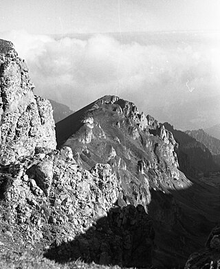
The Bucegi Mountains are located in central Romania, south of the city of Brașov. They are part of the Southern Carpathians group of the Carpathian Mountains. At 2,505 m (8,219 ft), Omu is its highest point.

Romania's tourism sector had a direct contribution of EUR 5.21 billion to the Gross Domestic Product (GDP) in 2018, slightly higher than in 2017, placing Romania on the 32nd place in the world, ahead of Slovakia and Bulgaria, but behind Greece and the Czech Republic. The total tourism sector's total contribution to Romania's economy, which also takes into account the investments and spending determined by this sector, was some EUR 15.3 billion in 2018, up by 8.4% compared to 2017.

The Southern Carpathians are a group of mountain ranges located in southern Romania. They cover the part of the Carpathian Mountains located between the Prahova River in the east and the Timiș and Cerna Rivers in the west. To the south they are bounded by the Balkan Mountains in eastern Serbia.

Prahova Valley is the valley where the Prahova river makes its way between the Bucegi and the Baiu Mountains, in the Carpathian Mountains, Romania. It is a tourist region, situated about 100 km (62 mi) north of the capital city of Bucharest.
In Romanian mythology, Baba Dochia, or The Old Dokia, is a figure identified with the return of spring. She is sometimes imagined as "an old woman who insults the month of March when she goes out with a herd of sheep or goats." Supposedly the name originates from the Byzantine calendar, which celebrates the 2nd-century martyr-saint Eudokia of Heliopolis (Evdokia) on March 1. The Romanian Dokia personifies mankind's impatience in waiting for the return of spring.

The Ceahlău Massif is one of the most famous mountains of Romania. It is part of the Bistrița Mountains range of the Eastern Carpathians division, in Neamț County, in the Moldavia region. The two most important peaks are Toaca and Ocolașul Mare. It is bounded to the east by the river Bistrița and Lake Bicaz, to the south by the river Bicaz. From the south, the main access point is the village of Izvorul Muntelui, located 12 km north from the town of Bicaz. To the north, Mount Ceahlău is also accessible from Durău.

The Piatra Craiului Mountains are a mountain range in the Southern Carpathians in Romania. Its name is translated as Kings' Rock or The Rock of the Prince. The mountain range is located in Brașov and Argeș counties; it is included in the Piatra Craiului National Park, which covers an area of 14,766 hectares (60 sq mi).
The Caraiman Peak is a mountain peak located in Romania, in the Bucegi Mountains of the Southern Carpathians. It has a height of 2,384 m. The nearest town is Buşteni.
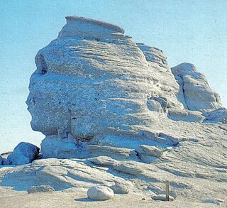
The Sphinx is a natural rock formation in the Bucegi Natural Park which is in the Bucegi Mountains of Romania. It is located at an altitude of 2,216 metres (7,270 ft) within the Babele complex of rock formations.

The Leaota Mountains are located in central Romania, north of the city of Târgoviște. They are part of the Southern Carpathians group of the Carpathian Mountains, and have as neighbours the Bucegi Mountains to the east and Piatra Craiului to the west. The mountains cover an area of 346 km2 (134 sq mi) within Dâmbovița, Argeș, and Brașov counties.
The Valea Cerbului is a right tributary of the river Prahova in Romania. It source is in the Bucegi Mountains. It flows into the Prahova in Bușteni. Its length is 7 km (4.3 mi) and its basin size is 26 km2 (10 sq mi).

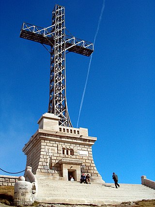
The Commemorative Cross to the Romanian Heroes of the First World War, also called the Heroes' Cross on Mount Cairaman is a monument built between 1926 and 1928 on Caraiman Peak at an altitude of 2,291 m located in Romania, in the Bucegi Mountains of the Southern Carpathians. It has a height of 39.3 metres (129 ft) and the nearest town is Buşteni. The name of the monument is "The Heroes' Cross", but it is popularly known as the "Cross on Caraiman".
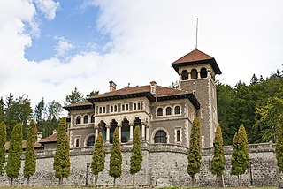
Cantacuzino Castle is situated in Bușteni, Romania, in the Zamora district, on the street bearing the same name. The building has a great architectural, historical, documentary and artistic value.

The Bucegi Natural Park is a protected area situated in Romania, in the administrative territory of counties Brașov, Dâmbovița and Prahova.
The Padina Plateau is high-altitude region in the Bucegi Mountains situated at 1500m above sea level. Among the plateau's attractions is the Bolboci Lake. Also on the plateau is the Padina National Mountain Rescue Centre. Nearby is the Babele area of rock formation and the Omu Peak (2505m), the 11th highest point in Romania. The Padina Plateau and Chalet is a camping location in the Bucegi mountains of Romania. It is located next to the Tatarului Gorges, which were carved out by the Lalomita river.

