The Tennessee River is the largest tributary of the Ohio River. It is approximately 652 miles (1,049 km) long and is located in the southeastern United States in the Tennessee Valley. The river was once popularly known as the Cherokee River, among other names, as many of the Cherokee had their territory along its banks, especially in eastern Tennessee and northern Alabama. Its current name is derived from the Cherokee village Tanasi.

The Red Cedar River is a tributary of the Grand River in central Michigan in the United States. The river is approximately 51.1 miles (82.2 km) long and drains a watershed of approximately 461 square miles (1,190 km2) in the Lansing–East Lansing metropolitan area and suburban and rural areas to the east.

Tornado is a census-designated place (CDP) in Kanawha County, West Virginia, United States. Tornado is also known as Upper Falls, the U.S. Census Bureau's official name for the community. The United States Board on Geographic Names declared the community's official name to be Tornado in 2013 due to a request from the Kanawha County Commission, which determined that residents of the community supported the name Tornado over Upper Falls. It is also known as Andrews Heights, Big Bend and Upper Falls of Coal River.
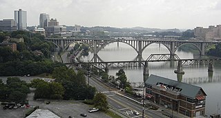
The Clinch River rises near Tazewell, Virginia, and flows southwest for more than 300 miles (480 km) through the Great Appalachian Valley, gathering various tributaries, including the Powell River, before joining the Tennessee River in Kingston, Tennessee.

Sleepy Creek is a 44.0-mile-long (70.8 km) tributary of the Potomac River in the United States, belonging to the Chesapeake Bay's watershed. The stream rises in Frederick County, Virginia, and flows through Morgan County, West Virginia before joining the Potomac near the community of Sleepy Creek.

The White Salmon River is a 44-mile (71 km) tributary of the Columbia River in the U.S. state of Washington. Originating on the slopes of Mount Adams, it flows into the Columbia Gorge near the community of Underwood. Parts of the river have been designated Wild and Scenic. The principal tributaries of the White Salmon River include Trout Lake and Buck, Mill, Dry, Gilmer, and Rattlesnake Creeks.

Seneca Creek is a 19.6-mile-long (31.5 km) tributary of the North Fork of the South Branch of the Potomac River located entirely within Pendleton County, West Virginia, USA.
Little River is a 23.4-mile-long (37.7 km) tributary stream of Goose Creek in Fauquier and Loudoun counties in northern Virginia. Via Goose Creek, it is a tributary of the Potomac River.

The Ohio River Islands National Wildlife Refuge (ORINWR) is a National Wildlife Refuge (NWR) in non-contiguous sites consisting of islands along 392 miles (631 km) of the Ohio River, primarily in the U.S. state of West Virginia. There are also a two of islands upstream in Beaver County, Pennsylvania and a two downstream in Lewis County, Kentucky. Going downstream, the refuge is currently located in parts of these counties: Beaver, Brooke, Ohio, Marshall, Wetzel, Tyler, Pleasants, Wood, Jackson, Mason, and Lewis. All counties are in West Virginia, with the exceptions of Beaver, which is in Pennsylvania, and Lewis, which is in Kentucky. The ORINWR was established in 1990 and consists of 3,354 acres (13.57 km2) of land and underwater habitat on 22 islands and four mainland properties. The refuge headquarters and visitors center is located in Williamstown, West Virginia. Prior to its establishment, West Virginia was the only state of the United States without a NWR.
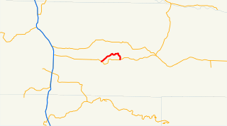
State Route 122 (SR 122) is a 7.88-mile-long (12.68 km) state highway on the north shore of Lake Mayfield in rural Lewis County, located within the U.S. state of Washington. The highway begins at U.S. Route 12 (US 12) in Silver Creek and travels east through Ike Kinswa State Park before turning south over the Cowlitz River to Mossyrock, ending at US 12. SR 122 was established in 1991 on roads built in the 1910s and 1940s and the designation was transferred from SR 142.
Belva is an unincorporated community and census-designated place in west Nicholas County and north Fayette County, West Virginia, United States; while the CDP only includes the Nicholas County portion, the Fayette County portion is considered part of the community. The town is situated at the bottomland surrounding the convergence of Bells Creek with Twentymile Creek and, subsequently, Twenty Mile Creek with the Gauley River. Belva is also the location of the convergence of two state highways: West Virginia Route 16 and West Virginia Route 39.
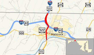
U.S. Route 522 is a part of the U.S. Highway System that runs from Powhatan, Virginia to Selinsgrove, Pennsylvania. In Maryland, it runs 2.35 miles (3.78 km) from the West Virginia state line at the Potomac River north to the Pennsylvania state line within Hancock in western Washington County. US 522 crosses Maryland at its narrowest north–south point, meeting Maryland Route 144, Interstate 70 (I-70), US 40, and I-68 before entering Pennsylvania concurrent with I-70. Warfordsburg Road from US 40 north to Pennsylvania was paved around 1920 and designated US 522 in the late 1920s. US 522 was extended south into West Virginia shortly after a new bridge was completed over the Potomac River in the late 1930s. It was moved onto I-70 north of Hancock when the Interstate highway was completed in the area in the mid 1960s.

Clover Creek is an unincorporated community in Highland County, Virginia, United States. Clover Creek is located 10 miles (16 km) south-southeast of Monterey, Virginia on State Route 678. The community is situated in the Bullpasture Valley along the path of the Bullpasture River. Beginning in 1897 with a decision by the United States Board on Geographic Names, the community was officially referred to as the single-word "Clovercreek"; however, in 1970, the board modified the community's name to the current two-word "Clover Creek". During the French and Indian War, a British fort named Fort George was built near Clover Creek in 1754 consisting of a wooden stockade 90 feet (27 m) square. The fort was never directly attacked, though arrows were at one point launched against the fort from a distance leaving no damage. George Washington may have visited the fort while traveling in the area, marking the only time Washington visited the region which is now known as Highland County.

Mill Gap is an unincorporated community and small rural village in Highland County, Virginia, United States. Mill Gap is located 9.1 miles (14.6 km) southwest of Monterey, Virginia on Virginia State Route 84. The community is located near a water gap of the same name that separates the ridges of Lantz Mountain and Little Mountain through which the East Back Creek flows. As of 2015, the community consists only of a general store and a church, with attached residences.
Davis Creek is a tributary of the Kanawha River, 9.4 miles (15.1 km) long, in West Virginia in the United States. Via the Kanawha and Ohio rivers, it is part of the watershed of the Mississippi River, draining an area of 47.1 square miles (122 km2) on the unglaciated portion of the Allegheny Plateau, in the Charleston metropolitan area.

McKim Creek is a tributary of Middle Island Creek, 20.4 miles (32.8 km) long, in northwestern West Virginia in the United States. Via Middle Island Creek and the Ohio River, it is part of the watershed of the Mississippi River, draining an area of 37.3 square miles (97 km2) in a rural region on the unglaciated portion of the Allegheny Plateau.

Forks of Waters is an unincorporated community located in Highland County, Virginia, United States. Forks of Waters is located approximately 6 miles (9.7 km) northeast of Monterey, Virginia at the junction of U.S. Route 220 and Virginia State Route 642. Forks of Waters is so named due to the convergence of the Strait Creek with the South Branch Potomac River near the community. After passing through Forks of Waters, the South Branch Potomac River enters West Virginia approximately 1 mile (1.6 km) to the northeast.


