Related Research Articles
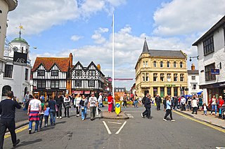
Stratford-upon-Avon, commonly known as just Stratford, is a market town and civil parish in the Stratford-on-Avon district, in the county of Warwickshire, in the West Midlands region of England. It is situated on the River Avon, 91 miles (146 km) north-west of London, 22 miles (35 km) south-east of Birmingham and 8 miles (13 km) south-west of Warwick. The town is the southernmost point of the Arden area on the edge of the Cotswolds. In the 2021 census Stratford had a population of 30,495.
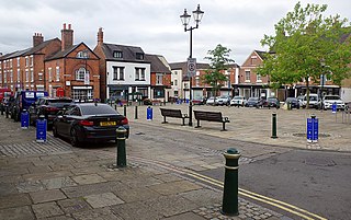
Atherstone is a market town and civil parish in the North Warwickshire district of Warwickshire, England. Located in the far north of the county, Atherstone is on the A5 national route, and is adjacent to the border with Leicestershire which is here formed by the River Anker. It is only 4+1⁄2 miles from Staffordshire. It lies between the larger towns of Tamworth and Nuneaton. Atherstone is the administrative centre of the North Warwickshire district, with the offices of North Warwickshire Borough Council located in the town.

Newport is a constituent market town in Telford and Wrekin in Shropshire, England. It lies 6 miles (10 km) north of Telford, 12 miles (19 km) west of Stafford, and is near the Shropshire-Staffordshire border. The 2001 census recorded 10,814 people living in the town's parish, which rose to 11,387 by the 2011 census.

An alley or alleyway is a narrow lane, path, or passageway, often reserved for pedestrians, which usually runs between, behind, or within buildings in the older parts of towns and cities. It is also a rear access or service road, or a path, walk, or avenue in a park or garden.

Lanark is a town in South Lanarkshire, Scotland, located 20 kilometres to the south-east of Hamilton. The town lies on the River Clyde, at its confluence with Mouse Water. In 2016, the town had a population of 9,050.
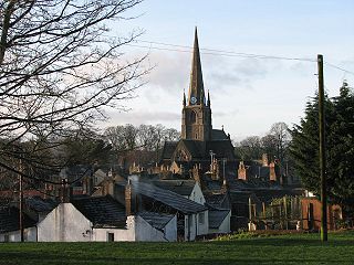
Cockermouth is a market town and civil parish in the Borough of Allerdale in Cumbria, England, so named because it is at the confluence of the River Cocker as it flows into the River Derwent. The mid-2010 census estimates state that Cockermouth has a population of 8,204, increasing to 8,761 at the 2011 Census.

Wickwar is a village and civil parish in Gloucestershire, England, located between Yate and Charfield. At the 2001 census, the parish had a population of 1,943.

House numbering is the system of giving a unique number to each building in a street or area, with the intention of making it easier to locate a particular building. The house number is often part of a postal address. The term describes the number of any building with a mailbox, or even a vacant lot.
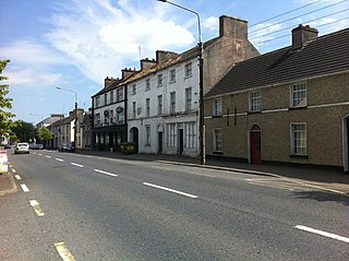
Borris-in-Ossory is a village in west County Laois, Ireland, close to the Tipperary border and the M7 motorway.

Burgage is a medieval land term used in Great Britain and Ireland, well established by the 13th century.

Gropecunt Lane was a street name found in English towns and cities during the Middle Ages, believed to be a reference to the prostitution centred on those areas; it was normal practice for a medieval street name to reflect the street's function or the economic activity taking place within it. Gropecunt, the earliest known use of which is in about 1230, appears to have been derived as a compound of the words grope and cunt. Streets with that name were often in the busiest parts of medieval towns and cities, and at least one appears to have been an important thoroughfare.

Hindon is a village and civil parish in Wiltshire, England, about 16 miles (26 km) west of Salisbury and 9.6 miles (15.4 km) south of Warminster. It is in the Cranborne Chase and West Wiltshire Downs Area of Outstanding Natural Beauty. Hindon was a market town but is now a village.

Briggate is a pedestrianised principal shopping street in Leeds city centre, England. Historically it was the main street, leading north from Leeds Bridge, and housed markets, merchant's houses and other business premises. It contains many historic buildings, including the oldest in the city, and others from the 19th and early-20th century, including two theatres. It is noted for the yards between some older buildings with alleyways giving access and Victorian shopping arcades, which were restored in late 20th century. The street was pedestrianised in the late-20th century.

Alley Cats Strike is a Disney Channel Original Movie that premiered on March 18, 2000. Directed by Rod Daniel, it stars Kyle Schmid, Robert Ri'chard, and Kaley Cuoco.

Rothe House is a late 16th-century merchant's townhouse complex located in the city of Kilkenny. The complex was built by John Rothe Fitz-Piers between 1594–1610 and is made up of three houses, three enclosed courtyards, and a large reconstructed garden with orchard. As a museum, it is accessible to the public.
A nucleated village, or clustered settlement, is one of the main types of settlement pattern. It is one of the terms used by geographers and landscape historians to classify settlements. It is most accurate with regard to planned settlements: its concept is one in which the houses, even most farmhouses within the entire associated area of land, such as a parish, cluster around a central church, which is close to the village green. Other focal points can be substituted depending on cultures and location, such as a commercial square, circus, crescent, a railway station, park or a sports stadium.

A vennel is a passageway between the gables of two buildings which can in effect be a minor street in Scotland and the north east of England, particularly in the old centre of Durham.

The Ancient Priors is a medieval timber-framed hall-house on the High Street in Crawley, a town and borough in West Sussex, England. It was built in approximately 1450, partly replacing an older structure—although part of this survives behind the present street frontage. It has been expanded, altered and renovated many times since, and fell into such disrepair by the 1930s that demolition was considered. It has since been refurbished and is now a restaurant, although it has been put to various uses during its existence. Secret rooms, whose purpose has never been confirmed for certain, were discovered in the 19th century. English Heritage has listed the building at Grade II* for its architectural and historical importance, and it has been described as Crawley's "most prestigious medieval building" and "the finest timber-framed house between London and Brighton".

St James House is a grade II listed building in Monmouth, Monmouthshire, Wales. It is in the historic St James Square neighbourhood, within the Medieval town walls. While the house currently has an attractive, 18th-century facade, it originated as a burgage tenement. In addition, behind the house, evidence of a kiln has been unearthed, with both Medieval and Post-medieval pottery. In 2010, archaeological excavation in the square revealed the first evidence of Mesolithic human settlement in Monmouth. Recent residents of St James House have included boarding students from Monmouth School.

The vennels of Perth are a collection of small medieval streets in the city of Perth, Scotland. Similar to York's Snickelways, vennels are a public right-of-way passageway between the gables of buildings which can, in effect, be a minor street. In Scotland, the term originated in royal burghs created in the twelfth century, the word deriving from the Old French word venelle meaning "alley" or "lane". Unlike a tenement entry to private property, known as a "close", a vennel was a public way leading from a typical high street to the open ground beyond the burgage plots. The Latin form is venella, related to the English word "funnel".
References
- ↑ Slater, Terry R. (2004). "Planning English medieval 'street towns': the Hertfordshire evidence". Landscape History. 26 (1): 19–35. doi:10.1080/01433768.2004.10594560. ISSN 0143-3768. S2CID 129559866.
- ↑ Slater, Terry R (2004). "Planning English medieval 'street towns'" (PDF). School of Geography, Earth and Environmental Sciences – University of Birmingham. Archived from the original (PDF) on September 6, 2004.
- ↑ "Back Lanes". City of Surrey. Archived from the original on 2016-04-16. Retrieved 2016-04-18.
| | This European history–related article is a stub. You can help Wikipedia by expanding it. |
| | This road-related article is a stub. You can help Wikipedia by expanding it. |