Bad Fallingbostel

Last updated
Bad Fallingbostel
St.-Dionysius-Kirche in Bad Fallingbostel IMG 8754.jpg
Saint Dionysius Church
Flagge Bad Fallingbostel.svg
Wappen Bad Fallingbostel.png
Location of Bad Fallingbostel within Heidekreis district
Bad Fallingbostel in HK.svg
Germany adm location map.svg
Red pog.svg
Bad Fallingbostel
Lower Saxony location map.svg
Red pog.svg
Bad Fallingbostel
Coordinates: 52°52′03″N09°41′48″E / 52.86750°N 9.69667°E / 52.86750; 9.69667 Coordinates: 52°52′03″N09°41′48″E / 52.86750°N 9.69667°E / 52.86750; 9.69667
Country Germany
State Lower Saxony
District Heidekreis
Government
   Mayor (202126) Rolf Schneider [1] (SPD)
Area
  Total63.15 km2 (24.38 sq mi)
Elevation
67 m (220 ft)
Population
 (2020-12-31) [2]
  Total12,174
  Density190/km2 (500/sq mi)
Time zone UTC+01:00 (CET)
  Summer (DST) UTC+02:00 (CEST)
Postal codes
29683
Dialling codes 05162, 05163
Vehicle registration HK
Website www.badfallingbostel.de

Bad Fallingbostel (Northern Low Saxon: Bad Fambossel) is the district town (Kreisstadt) of the Heidekreis district in the German state of Lower Saxony. Since 1976 the town has had a state-recognised Kneipp spa and has held the title of Bad since 2002. It has close ties to Walsrode, a few miles to the west. Until 2015, there was a British Army base in Bad Fallingbostel, It also hosted Defender 2020 the largest US Army/Nato exercise since the Cold war. The town has around 11,000 inhabitants.

Contents

Geography

Location

Bad Fallingbostel lies on the Böhme river in the southern part of the Lüneburg Heath between Soltau and Walsrode in the Heidmark.

Sub-divisions

The administrative borough of Bad Fallingbostel is also responsible for the villages of Dorfmark, Riepe, Vierde, Jettebruch and Mengebostel as well as the town itself.

The core city is divided into the following districts:

History

Bad Fallingbostel was first mentioned as “Vastulingeburstalle“ in 993 and has therefore a recorded history of over 1,000 years. Originally it was a purely agricultural settlement, due to agriculture being the basis for life of the inhabitants of the old-Saxon Loingau. The name “Vastulingeburstalle“ means either “House of the Vastulo“ or “House of the Vastulingians“. Otto III drew the borders between the dioceses Hildesheim and Minden during that time.

The Vogtei Fallingbostel (bailiwick) was established around 1300. It was later also called Amt Fallingbostel and it existed until the 19th century. In 1838 Heinrich von Quintus-Icilius, the assessor of the Vogtei, founded the “Sparcasse für die Amtsvogtei Fallingbostel”, one of the first rural savings banks in the Kingdom of Hannover. In 1866 the newly Prussian province of Hannover was divided into administrative districts, one of them was the district Fallingbostel. Fallingbostel was awarded its status as a town in 1949.

During World War II Fallingbostel was the site of two POW (prisoner-of-war) camps, Stalag XI-B and Stalag XI-D / 357. [3]

Demographics

Religion

The majority of the church-going Christian residents of the town belong to the Lutheran church. Within the borough there are two church parishes:

They are served by three pastors. Both parishes belong to the church district of Walsrode in the diocese of Lüneburg, which is part of the Evangelical Lutheran Church of Hanover.

The Catholic Christians in Bad Fallingbostel belong to the Roman Catholic parish of St. Mary of the Holy Rosary (Sankt Maria vom heiligen Rosenkranz), which was founded in August 2004. This merged the hitherto independent Catholic parish of St. Mary in Bad Fallingbostel with the neighbouring parishes of St. Mary's Church in Walsrode and the Church of the Holy Spirit in Bomlitz-Benefeld as well as the Church of the Sacred Heart in Visselhövede. The parish lies in the church district of Verden in the Roman Catholic Diocese of Hildesheim.

Government

"Adopted town"

In 1963 Bad Fallingbostel adopted the town of Miastko (German : Rummelsburg) in Pomerania, Poland. Every two years they meet in Bad Fallingbostel.

Town-twinning

Bad Fallingbostel is twinned today with the Polish town of Miastko (see above) and with the French town of Périers in Lower Normandy.

Proposed merger into the town of Böhmetal

The Bohme valley in the Lieth Boehme-Tal Lieth.jpg
The Böhme valley in the Lieth

A merger of Bad Fallingbostel with the town of Walsrode and the municipality of Bomlitz was planned for 2011 to create the town of Böhmetal. Following a referendum on 2 November 2008 this plan was rejected by the citizens in Bad Fallingbostel with a clear majority. Just under 62% of the voters turned out, of whom 80% were against the merger. [4] In Walsrode and Bomlitz a small majority were in favour of a merger (56.4% in Bomlitz and 53.8% in Walsrode). On 10 November 2008 the town council of Bad Fallingbostel voted against the merger.

Arts and culture

Memorial to Heinrich von Quintus Icilius (1864) Denkmal Quintus Icilius 03.jpg
Memorial to Heinrich von Quintus Icilius (1864)
The Hof der Heidmark in an old Low German farmhouse Hof der Heidmark.jpg
The Hof der Heidmark in an old Low German farmhouse

Events

Between 1997 and 2002 demoparties for the computing world took place in Bad Fallingbostel under the name of "Mekka & Symposium".

Places of interest

Infrastructure

Military installations

The town is not far from the large military training area of Bergen-Hohne, which is currently used by the Bundeswehr and by NATO forces. This is located in the gemeindefreie Gebiete (i.e. areas not part of any civilian administrative district) known as Osterheide and Lohheide. In addition, there was Fallingbostel Station, a large barracks within Bergen-Hohne Garrison, itself part of British Forces Germany. This was used by units from the 7th Armoured Brigade.

Fallingbostel Station was closed in 2015 as the British Army reduces its presence in Germany ahead of a complete withdrawal by 2020—a result of the 2010 Strategic Defence and Security Review. [5]

Transport

Bad Fallingbostel has two railway stations - Bad Fallingbostel and Dorfmark - on the Heath Railway from Hanover to Soltau.

Bad Fallingbostel lies on the A 7 motorway between the Walsrode three-way intersection and the Maschener Kreuz four-way intersection.

Notable people

People from the town

Friedrich Freudenthal Freudenthal BomannMuseum@20150903.jpg
Friedrich Freudenthal

People associated with the town

Erich von Manstein 1938 Bundesarchiv Bild 183-H01757, Erich von Manstein.jpg
Erich von Manstein 1938

Related Research Articles

Heidekreis District in Lower Saxony, Germany

Heidekreis is a district (Landkreis) in Lower Saxony, Germany. It is bounded by the districts of Harburg, Lüneburg, Uelzen, Celle, Hanover, Nienburg, Verden and Rotenburg.

Soltau Town in Lower Saxony, Germany

Soltau is a mid-sized town in the Lüneburg Heath in the district of Heidekreis, in Lower Saxony, Germany. It has around 22,000 inhabitants. The city is centrally located in the Lüneburg Heath and is known nationwide especially for its tourist attractions like the Heide-Park and the Soltau-Therme.

Walsrode Town in Lower Saxony, Germany

Walsrode is a town in the district of Heidekreis, in Lower Saxony, Germany. The former municipality Bomlitz was merged into Walsrode in January 2020.

Böhme (river) River in Germany

The Böhme is a right-bank, northeastern tributary of the Aller in the district of Soltau-Fallingbostel in the north German state of Lower Saxony. The river is 72 kilometres (45 mi) long.

Bergen, Lower Saxony Town in Lower Saxony, Germany

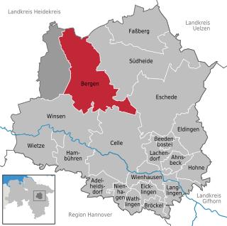
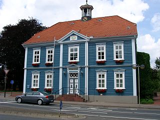
Bergen is a town in the north of Celle district on the Lüneburg Heath, in Lower Saxony, Germany. Administratively it acts as a municipal borough divided into 12 subordinate parishes based on the town and its surrounding villages: Becklingen, Belsen, Bergen, Bleckmar, Diesten, Dohnsen, Eversen, Hagen, Hassel, Offen, Sülze and Wardböhmen. Bergen-Belsen concentration camp was located in the area of Belsen.

Sieben Steinhäuser

The Sieben Steinhäuser is a group of five dolmens on the Lüneburg Heath in the NATO training area of Bergen-Hohne, in the state of Lower Saxony in northern Germany. The stones are considered to be part of the funnelbeaker culture. The gravesite was granted protected cultural monument status in 1923.

The Osthannoversche Eisenbahnen AG (OHE) is a Celle based transportation company with railway network in North-eastern Lower Saxony around the Lüneburg Heath area of over 250 km.

Bergen-Hohne Training Area

Bergen-Hohne Training Area is a NATO military training area in the southern part of the Lüneburg Heath, in the state of Lower Saxony in northern Germany. It covers an area of 284 square kilometres, which makes it the largest military training area in Germany.

The Heidmark is an area of the Lüneburg Heath, much of which has not been accessible to the population since about 1935/1936. The establishment of a large military training area by the German armed forces, the Wehrmacht, as part of their rearmament and preparation for war resulted in the evacuation of 24 villages and, since then the training area has been out-of-bounds to non-military personnel. Today it has become the Bergen-Hohne Training Area, the largest of its kind in Europe.

Heath Railway

The Heath Railway is a regional railway line in North Germany that crosses the Lüneburg Heath from which it derives its name. Most of the line is unelectrified and single-tracked. It links Buchholz in der Nordheide with Hanover, the capital city of Lower Saxony. Together with the east-west Uelzen–Langwedel railway, this north-south line is one of the two most important railways on the heath.

Vierde Ortsteil of Bad Fallingbostel in Lower Saxony, Germany

Vierde is a village within the borough of Bad Fallingbostel in Soltau-Fallingbostel district in the Heidmark.

Bundesstraße 440

The B 440 is a German federal road in Lower Saxony. It runs from the district town of Rotenburg an der Wümme to Bad Fallingbostel. It was based on an old Army road built by Napoléon Bonaparte.

Hans Stuhlmacher

Hans Albert Alexander Louis Carl Stuhlmacher (1892–1962) was a German pedagogue, Wehrmacht officer and local historian.

Dorfmark

The village of Dorfmark is part of the borough of Bad Fallingbostel in Heidekreis district in the German state of Lower Saxony.

The Vehmsmoor is a nature reserve in North Germany. It is located in the borough of Walsrode within the district of Soltau-Fallingbostel in Lower Saxony. Its classification number is NSG LÜ 182.

Bomlitz (river) River in Lower Saxony, Germany

The Bomlitz is a right-bank tributary of the River Böhme in North Germany. It is just under 18 kilometres (11 mi) long and runs through the Heidekreis district in Lower Saxony.

Kroge is a village in the town of Walsrode in North Germany. It lies in the Lower Saxony district of Soltau-Fallingbostel. The village has 290 inhabitants and an area of 7 square kilometres (2.7 sq mi).

Uetzingen is a village in the town of Walsrode in North Germany. It lies in the Lower Saxon district of Heidekreis. The village has 462 inhabitants and its parish covers an area of 10 km².

Bommelsen

Bommelsen is a village in the town of Walsrode in North Germany. It lies in the Lower Saxon Heidekreis district. The parish has about 286 inhabitants and an area of 10 km².

Benefeld is part of the municipality of Walsrode in the Lower Saxon Heidekreis district in north Germany. Benefeld has a population of 2,232, although its parish covers just 2 km².

References

  1. "Direktwahlen in Niedersachsen vom 12. September 2021" (PDF). Landesamt für Statistik Niedersachsen. 13 October 2021.
  2. Landesamt für Statistik Niedersachsen, LSN-Online Regionaldatenbank, Tabelle A100001G: Fortschreibung des Bevölkerungsstandes, Stand 31. Dezember 2020.
  3. "Stalag XI B / 357". Fallingbostel Military Museum. Retrieved 12 May 2013.
  4. Results of the referendum in Bad Fallingbostel (German)/
  5. "Farewell to Fallingbostel after 70 years". British Army. Retrieved 28 December 2015.