Upper Franconia is a Regierungsbezirk of the state of Bavaria, southern Germany. It forms part of the historically significant region of Franconia, the others being Middle Franconia and Lower Franconia, which are all now part of the German Federal State of Bayern (Bavaria).
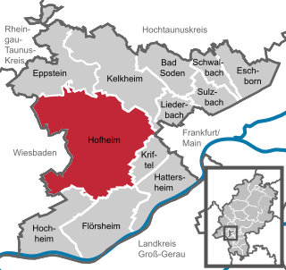
Hofheim is the administrative centre of Main-Taunus-Kreis district, in the south of the German state of Hesse. Its population in September 2020 was 39,946.
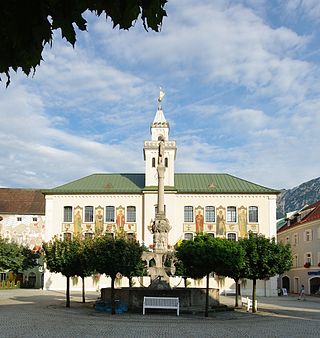
Bad Reichenhall is a spa town, and administrative center of the Berchtesgadener Land district in Upper Bavaria, Germany. It is located near Salzburg in a basin encircled by the Chiemgau Alps. Together with other alpine towns Bad Reichenhall engages in the Alpine Town of the Year Association for the implementation of the Alpine Convention to achieve sustainable development in the alpine arc. Bad Reichenhall was awarded Alpine Town of the Year in 2001.
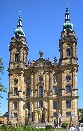
The Basilica of the Fourteen Holy Helpers is a church located near the town of Bad Staffelstein near Bamberg, in Bavaria, southern Germany. The late Baroque (Rococo) basilica, designed by Balthasar Neumann, was constructed between 1743 and 1772. It is dedicated to the Fourteen Holy Helpers, a group of saints venerated together in the Catholic Church, especially in Germany at the time of the Black Death. The interior has been nicknamed "God's Ballroom".
Plassenburg is a castle in the city of Kulmbach in Bavaria. It is one of the most impressive castles in Germany and a symbol of the city. It was first mentioned in 1135. The Plassenberg family were ministerial of the counts of Andechs and used as their seat the Plassenburg. The House of Guttenberg, a prominent Franconian noble family, traces its origins back to 1149 with a Gundeloh v. Blassenberg (Plassenberg). The name Guttenberg is derived from Guttenberg and was adopted by a Heinrich von Blassenberg around 1310. From 1340, the Hohenzollerns governed from Plassenburg castle their territories in Franconia till 1604. The Plassenburg was fortress and residence for the Hohenzollerns.

Bad Wiessee is a municipality in the district of Miesbach in Upper Bavaria in Germany. Since 1922, it has been a spa town and located on the western shore of the Tegernsee Lake. It had a population of around 4800 inhabitants in 2014. The word "Bad" means "spa" or "baths", while "Wiessee" derives from "Westsee", meaning "western part of the lake". Bad Wiessee was first documented in 1017 in the tax book of the Tegernsee Abbey, encouraged to pay goods to the abbey.

Bad Lobenstein is a spa town in the Saale-Orla-Kreis district, in Thuringia, Germany with a population of about 6,000 inhabitants. Until 2005, the town was named Lobenstein.
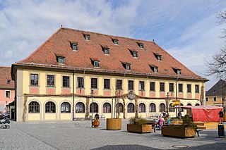
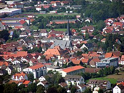
Lichtenfels is a town in the Upper Franconian region of Bavaria, Germany, the administrative seat of Lichtenfels district. It is chiefly known as the German "Basket City".

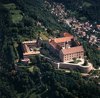
Langheim Abbey was a well-known Cistercian monastery in Klosterlangheim, part of the town of Lichtenfels in Upper Franconia, Bavaria, Germany, in the Bishopric of Bamberg.

Banz Abbey, now known as Banz Castle, is a former Benedictine monastery, since 1978 a part of the town of Bad Staffelstein north of Bamberg, Bavaria, southern Germany.

Baunach is a town in the Upper Franconian district of Bamberg and the seat of the administrative community (Verwaltungsgemeinschaft) of Baunach. Until administrative reform in 1972, Baunach belonged to the Lower Franconian district of Ebern.

Hallstadt is a town in the Upper Franconian district of Bamberg on the left bank of the Main, 4 km north of Bamberg.

Kleinkahl is a community in the Aschaffenburg district in the Regierungsbezirk of Lower Franconia (Unterfranken) in Bavaria, Germany, and a member of the Verwaltungsgemeinschaft of Schöllkrippen. Kleinkahl has around 1,800 inhabitants.

Rattelsdorf is a municipality with market rights in the Upper Franconian district of Bamberg.

Bad Feilnbach is a municipality in the Upper Bavarian district of Rosenheim at the foot of Wendelstein Mountain in Germany. As a famous 'Moorheilbad' the municipality was awarded in 1973 the title "Bad". Since the 19th century the peat deposits were the basis for a continued expansion of the spa and health facilities. The recognized healing success of "black gold" on a variety of diseases were the basis for the development of a well-known spa and tourist community. Due to its wooded surroundings and the mild climate Feilnbach is called the "Bavarian Meran". The entire municipality is recognized as a healing spa resort except for parts of the former municipality Dettendorf.

Bad Bleiberg is a market town in the district of Villach-Land, in Carinthia, Austria. Originally a mining area, especially for lead, Bad Bleiberg today due to its hot springs is a spa town.

Bundesstraße 22 is a German federal highway that runs from Würzburg in Lower Franconia, through the Upper Franconian cities of Bamberg and Bayreuth and the Upper Palatine town of Weiden, to Cham. The highway acts as a bypass for the Upper Franconian villages of Seybothenreuth and Speichersdorf as well as the Upper Palatine towns of Kemnath, Erbendorf, Oberviechtach and Rötz, running past Cham (Oberpfalz), where it joins the B 20 and B 85 highways.
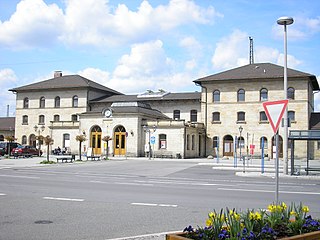
Lichtenfels station is in the town of Lichtenfels in Upper Franconia in the German state of Bavaria. It is a regional rail hub and a former ICE stop on the Hamburg–Berlin Munich route and is classified by Deutsche Bahn as a station of category 3.
Weilheim in Oberbayern is a town in Germany, the capital of the district Weilheim-Schongau in the south of Bavaria. Weilheim has an old city-wall, historic houses and a museum.

Gößweinstein Castle, also called Schloss Gößweinstein, is a mediaeval hilltop castle in Gößweinstein in the county of Forchheim in the German state of Bavaria. It towers high above the market town and the River Wiesent and may have been the inspiration for Richard Wagner's grail castle in his opera, Parsifal. The castle is a Bavarian listed building, no. D-4-74-129-10.