
Peeblesshire, the County of Peebles or Tweeddale is a historic county of Scotland. Its county town is Peebles, and it borders Midlothian to the north, Selkirkshire to the east, Dumfriesshire to the south, and Lanarkshire to the west.
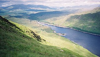
Loch Treig is a 9 km freshwater loch situated in a steep-sided glen 20 km east of Fort William, in Lochaber, Highland, Scotland. While there are no roads alongside the loch, the West Highland Line follows its eastern bank.
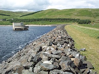
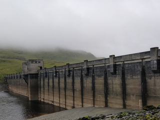
Megget Reservoir is an impounding reservoir in the Megget valley in Ettrick Forest, in the Scottish Borders. The 259 hectares reservoir is held back by the largest earth dam in Scotland. The reservoir collects water from the Tweedsmuir Hills, which is then conveyed 28 miles (45 km) via underground pipelines and tunnels to Edinburgh. The pipelines are routed through the Manor Valley and the Meldon Hills, to Gladhouse Reservoir and Glencorse Reservoir in the Pentland Hills. These two reservoirs store the water until such times as it is required. Excess water which overflows from the reservoir is returned to the Megget Water, and hence into St. Mary's Loch.

Talla Reservoir, located a mile from Tweedsmuir, Scottish Borders, Scotland, is an earth-work dam fed by Talla Water. The reservoir is supplemented by water from the nearby Fruid Reservoir. It was opened in 1905. To assist in bringing the materials for its construction, the Talla Railway was built.

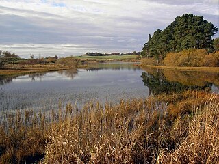
West Water Reservoir is an artificial reservoir in the Pentland Hills, Scottish Borders, 3 kilometres (1.9 mi) west of West Linton, and 26 kilometres (16 mi) south west of Edinburgh. It is a drinking water reservoir for Edinburgh and the Lothians and is located 320 metres (1,050 ft) above sea level. It is an important site for wildfowl and is designated as a SSSI and a Ramsar site.
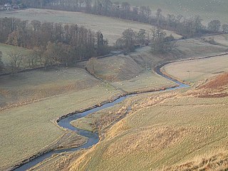
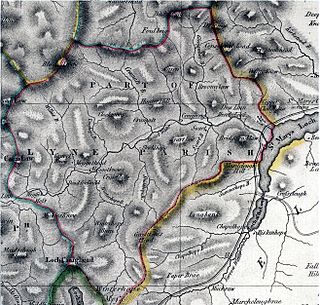
The Lyne Water is a tributary of the River Tweed that rises in the Pentland Hills of southern Scotland at Baddinsgill Reservoir. It runs through West Linton and Romannobridge, passes Flemington and Lyne Station and enters the Tweed west of Peebles. It floods regularly in winter and occasionally in summer. There is free fishing above Flemington Bridge, and below Flemington fishing in the river is administered by the Peebles fishing authority.
Addinston is a farming village, off the A697, close to the Carfraemill roundabout, with two hill forts and settlements, in Lauderdale in the Scottish Borders area of Scotland, in the former Berwickshire.
The Tummel hydro-electric power scheme is an interconnected network of dams, power stations, aqueducts and electric power transmission in the Grampian Mountains of Scotland. Roughly bounded by Dalwhinnie in the north, Rannoch Moor in the west and Pitlochry in the east it comprises a water catchment area of around 1,800 square kilometres and primary water storage at Loch Ericht, Loch Errochty, Loch Rannoch and Loch Tummel, in Perth and Kinross. Water, depending on where it originates and the path it takes, may pass through as many as five of the schemes nine power stations as it progresses from north-west to south-east. The scheme was constructed in the 1940s and 50s incorporating some earlier sites. It is managed by SSE plc.
Whiteadder Reservoir is a reservoir in East Lothian, Scotland, UK, in the Lammermuir Hills, 11 miles (18 km) north west of Duns in the Scottish Borders, and five miles (8 km) south east of Garvald. It was created to provide additional water facilities for East Lothian.
Cobbinshaw Reservoir is a reservoir in West Lothian, Scotland. It is situated near the Pentland Hills, 5 km south of West Calder. The 310-acre (1.3 km2) site is a Site of Special Scientific Interest (SSSI) and is popular with wildfowl.

Romanno Bridge is a village on the Lyne Water, on the A701, in the Scottish Borders area of Scotland.

The Watch Water is a river in the Scottish Borders area of Scotland. It rises in the Lammermuir Hills, around 8 kilometres (5.0 mi) west of Longformacus, and flows generally eastward to its confluence with the Dye Water, around 700 metres (2,300 ft) west of Longformacus. The Dye Water flows into the Whiteadder Water, which in turn is a tributary of the River Tweed.
Lindean is a village north of Selkirk and the Ettrick Water, in the Scottish Borders area of Scotland.

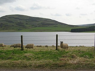
Megget Water is a river in the parish of Yarrow, Selkirkshire in the Scottish Borders area of Scotland. The Water rises at Broad Law (2,760 ft), passes through Megget Reservoir and empties into St Mary's Loch. Places in the vicinity include Cappercleuch, Craigierig, Cramalt Tower, the Glengaber Burn, Meggethead Farm.

Craigierig is a village on the Megget Reservoir, in the Scottish Borders area of Scotland, in the former Selkirkshire.
Dewar is a village by the Dewar Burn and Peatrig Hill, in the Scottish Borders area of Scotland.
The Breadalbane Hydro-Electric Scheme is a hydroelectric scheme in the Breadalbane area of Perthshire, Scotland. It comprises seven power stations which generate 120MW of power from the dams around Loch Lyon, Loch Earn and Loch Tay.
Megget is a former chapelry or parish containing the valley of Megget Water, now forming the westernmost part of the parish of Yarrow, Selkirkshire in the Scottish Borders area of Scotland. The centre of the valley is 19 miles west of Selkirk.

Walkerwood Reservoir is a reservoir in the Brushes valley above Stalybridge in Greater Manchester, built in the 19th century to provide a supply of safe drinking water. It is owned and operated by United Utilities.

