Bade, Nigeria

Last updated

Bade
LGA
Nigeria location map.svg
Red pog.svg
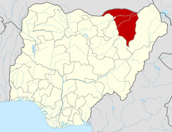
Bade
Location in Nigeria
Coordinates: 12°52′N10°58′E / 12.867°N 10.967°E / 12.867; 10.967
CountryFlag of Nigeria.svg  Nigeria
State Yobe State
Government
  Local Government ChairmanSanda Kara (APC)
Area
  Total772 km2 (298 sq mi)
Population
 (2006 census)
  Total139,782
  Ethnicities density90,690/km2 (234,890/sq mi)
Time zone UTC+1 (WAT)
3-digit postal code prefix
631
ISO 3166 code NG.YO.BA
Bade, Nigeria

Bade (or Barde or Badde) is a Local Government Area in Yobe State, Nigeria. It has its headquarters in the town of Gashua. Most of the people living in Bade are farmers and businessmen.

Contents

Landscape

It has an area of 772 km2.

Population

It has a total population of 139,782 at the 2006 census.

Postal code

The postal code of the area is 631. [1]

Languages

The Bade, Hausa, and Duwai languages are spoken in Bade LGA. [2] [3]

Climate

Bade experiences a semi-arid climate characterized by consistently warm to hot conditions throughout the year. The scarcity of trees in this region is primarily attributed to prolonged periods of drought. The predominant landscape comprises sandy terrain with occasional grasses and shrubs. Bade typically records an average annual temperature of 37 degrees Celsius and receives approximately 694 mm of rainfall annually. It remains arid for about 245 days each year, with an average humidity level of 33% and a UV-index of 8. [4] [5]

See also

Related Research Articles

Damaturu is a Local Government Area and the capital city of Yobe State in northern Nigeria. It is the headquarters of the Damaturu Emirate.

Bida is a Local Government Area in Niger State, Nigeria and a city on the A124 highway which occupies most of the area.

Biu is a town and a Local Government Area (LGA) in southern Borno State of Nigeria. The town is the administrative center of the LGA and was once the capital of the Biu kingdom, and is now capital of the Biu Emirate. Biu lies on the Biu Plateau at an average elevation of 626 meters. The region is semi-arid.

Kirfi is a Local Government Area of Bauchi State, Nigeria, bordering Gombe State in the east. Its headquarters are in the town of Kirfi. The northeasterly line of equal latitude and longitude passes through the Local Government Area.

Zaki is a Local Government Area of Bauchi State, Nigeria. Its headquarters are in the town of Katagum.

Marte is a Local Government Area of Borno State, Nigeria, on the western coast of Lake Chad. Its headquarters are in the town of Marte

Guri is a Local Government Area of Jigawa State, Nigeria. Its headquarters are in the town of Guri. [The big town of guri local government is] KADIRA.

Birnin Gwari is a Local Government Area in Kaduna State, Nigeria. Its headquarters are in the town of Birnin Gwari.

Kauru is a Local Government Area in southern Kaduna State, Nigeria. The area is 3,186 km2. Its headquarters are in the town of Kauru. The postal code of the area is 811.

Machina is a Local Government Area in Yobe State, Nigeria. Its headquarters are in the town of Machina at 13°08′11″N10°02′57″E. It shares a border in the north with The Republic of Niger.

Karasuwa is a Local Government Area in Yobe State, Nigeria. Its headquarters are in the town of Jajimaji on the Hadejia River at 12°53′57″N10°48′28″E.

Jakusko is a Local Government Area in Yobe State, Nigeria. Its headquarters are in the town of Jakusko in the west of the area at 12°22′09″N10°46′23″E.

Nangere is a Local Government Area in Yobe State, Nigeria. It has its headquarters in the town of Sabon Garin Nangere.

Yunusari is a Local Government Area in Yobe State, Nigeria. It has its headquarters in the town of Kanamma in the north-east of the area on the Burun Gana River at 13°06′15″N12°04′20″E. It shares a border in the north with The Republic of Niger.

<span class="mw-page-title-main">Geidam</span> LGA and town in Yobe State, Nigeria

Geidam is a Local Government Area in Yobe State, Nigeria. Its headquarters are in the town of Geidam in the northwest of the area at 12°53′49″N11°55′49″E. On 24 April 2021 terrorists from ISWAP seized Geidam killing 11 people, and over 6,000 residents were displaced. However, the Nigerian Armed Forces retook the town after an offensive against the terrorists.

Yusufari is a Local Government Area in Yobe State, Nigeria. Its headquarters are in the town of Yusufari in the south-east of the area at 13°04′06″N11°10′33″E. It shares a border in the north with The Republic of Niger.

Gujba is a town and Local Government Area in Yobe State, Nigeria. Its headquarters are situated in Buni Yadi at 11°16′08″N11°55′49″E towards the south of the area; the eponymous town of Gujba lies in the north of the area. It has an area of 3,239 km2 (1,251 sq mi) and a population of 130,088 at the 2006 census. The postal code of the area is 621. The town serves as the seat of the Gujba Emirate.

Gulani is a Local Government Area in Yobe State, Nigeria. Its headquarters are in the town of Bara.

Fika is a Local Government Area in Yobe State, Nigeria. Its headquarters are in the town of Fika in the south of the area at 11°17′00″N11°18′29″E.

Bursari is a Local Government Area in Yobe State, Nigeria. Its headquarters are in the town of Dapchi in the far south of the area at 12°29′25″N11°29′40″E.

References

  1. "Post Offices- with map of LGA". NIPOST. Archived from the original on 7 October 2009. Retrieved 2009-10-20.
  2. "Bade". Ethnologue. Retrieved 2014-05-25.
  3. "Duwai". Ethnologue. Retrieved 2014-05-25.
  4. "Bade weather and climate ☀️ Best time to visit 🌡️ Temperature". www.besttimetovisit.co.nz. Retrieved 2023-09-28.
  5. "Bade District climate: Temperature Bade District & Weather By Month". en.climate-data.org. Retrieved 2023-09-28.