Badshot Lea Long Barrow

Last updated

Badshot Lea Long Barrow, also known as Farnham Long Barrow, was an unchambered long barrow located near the village of Badshot Lea in the south-eastern English county of Surrey. It was probably constructed in the fourth millennium BCE, during Britain's Early Neolithic period.

Contents

Archaeologists have established that the monument was built by pastoralist communities shortly after the introduction of agriculture to Britain from continental Europe. Although representing part of an architectural tradition of long barrow building that was widespread across Neolithic Europe, the Badshot Lea Long Barrow is the only known example in Surrey. The nearest examples are the Medway Megaliths, clustered around the River Medway in Kent, and the long barrows of Sussex.

Built out of earth, the long barrow consisted of a tumulus flanked by side ditches. A timber post was embedded into the eastern end of the mound. By the mid-1930s, chalk quarrying adjacent to the long barrow had destroyed much of its southern side. In 1936, local resident W. F. Rankine discovered ox bones and stone arrow-heads in the vicinity of the site. An excavation was launched under the directorship of Alexander Keiller and Stuart Piggott, who sought to investigate the remains of the long barrow before it was destroyed by further quarrying.

Location

The Badshot Lea Long Barrow, which has also been called the Farnham Long Barrow, [1] was located near to Badshot Farm in the parish of Runfold, Surrey. [2] Standing on the western end of the Hog's Back ridge, [3] it was on a slope of Upper Chalk overlooking the Blackwater Gravels below. [4] It stood at approximately 85 metres (280 ft) above sea level. [5]

Context

In 1987, the archaeologists David Field and Jonathan Cotton stated Badshot Lea Long Barrow was "the most impressive Neolithic feature yet located within the historic county" of Surrey. [4] There are few known Neolithic monuments in Surrey, with most information about the area during the Neolithic period deriving from discoveries of worked flint scatters. [6] Among the other known monuments from this period are a causewayed enclosure at Staines and a cursus monument at Stanwell. [4]

Archaeologists believe that the primary importance of Badshot Lea Long Barrow is its location, isolated from other known examples of long barrows. [7] The nearest known long barrows are at Freefolk (22 miles to the west), Hinton Ampner (20 miles to the west/southwest), Old Winchester Hill (22 miles to the west/southwest) and Up Marden (21 miles to the west/southwest). [8] The next nearest group are the Medway Megaliths, a cluster of chambered long barrows in northwest Kent, which are located approximately 89 kilometres (55 mi) away. [9] The archaeologist Ronald Jessup suggested that the North Downs Trackway might have served as a link between these different locations. [3] Three earthen long barrows—Julliberrie's Grave, Jacket's Field Long Barrow, and Shrub's Wood Long Barrow—are also found near the River Stour in Kent, approximately 120 kilometres (75 mi) from the Badshot Lea Long Barrow. [10] The archaeologist Ian Kinnes classed the Badshot Lea example alongside the Preston Candover Long Barrow in Hampshire as the two known examples located on the North Downs. [11]

Material recovered from primary silts in the ditches of the Badshot Lea Long Barrow included charcoal produced from burnt hazel as well as a molluscan assemblage including snails which favoured damp scrub conditions. This evidence indicates the nature of the environment around the long barrow shortly after it was constructed in the Early Neolithic period. [12]

Design and construction

Badshot Lea Long Barrow was an earthen long barrow. [6] At the time of the site's excavation during the 1930s, the tumulus had been completely destroyed. Excavators believed that extensive agricultural activity had largely levelled it, [13] although most of it had also been quarried away from the south. [4] The excavators believed that this tumulus was once approximately 43 metres (140 ft) in length, [14] and that it had probably been higher at the eastern end than the western end. [15] No human bone was found at the site. [1]

The northern and southern sides of the tumulus were flanked with flat-bottomed, parallel ditches. [16] It was from these that the chalk used to build up the mound may have been dug. [15] Excavators found that the northern ditch measured 35 metres (116 ft) in length and that its depth varied; at the western end it measured 1.12 metres (3 ft 8 in) below the 1930s turf-level, while at the eastern end it measured 1.91 metres (6 ft 3 in) beneath that depth. [15] By the 1930s, most of the southern ditch had been destroyed by quarrying, preventing archaeologists from determining its exact dimensions. [15] However, the lack of any evidence for such a ditch on an area to the south-west of the tumulus led the excavators to suggest that the southern ditch was shorter than its northern counterpart. [17] They also estimated that the average width between the northern and southern ditches was approximately 15 metres (50 ft). [18]

At the eastern end of the monument, the northern and southern ditches did not meet, but left a causeway measuring 12 metres (40 ft) between them. [15] In the middle of this causeway was a posthole cut 0.15 metres (0 ft 6 in) into the undisturbed chalk. This would have held a wooden post which was probably contemporary with the rest of the structure. [19] Given how shallow the posthole was, it was probably that the eastern end of the earthen mound had also helped to support the original timber post. [15] The site's excavators believed that this post served no structural purpose and thus probably had a ritual function. [20] The excavators also noted that evidence for a very similar post had been found in the end of the Long Barrow 163A at Thickthorn Down in Dorset. [19]

Finds

In the primary silting in the surviving part of the southern ditch, excavators recovered three small fragments of unadorned pottery, which they attributed to a period they called "Neolithic A." [21] Radiocarbon dating of material recovered from this primary fill produced dates of 2530 BCE and 2650 BCE. [12]

Above this primary layer of silting was a deep layer of sandy red-brown loam that filled much of the southern ditch. [18] Found in this were fragments of a black ware vessel and one or two sherds of a pale ware vessel, [22] as well as fragments of a vessel that the excavators believed was Early Bronze Age in date. [23] In the same layer as the "Neolithic B" pottery from this ditch were also found the cutting edge of a broken polished flint axe and three stone scrapers. [24]

The sandy red-brown loam that filled the southern ditch was also found filling much of the northern ditch. [18] This layer contained many ceramic sherds which the archaeologists attributed to the period "Neolithic B", [18] later identified as Mortlake ware. [10] Many of the sherds of this type found in the northern ditch all belonged to the same vessel. As the sherds were distributed throughout the loam layer, it was believed that this deposit must have entered the ditch in an exceedingly rapid manner. [18] This broken vessel had a bevelled rim and hollow neck. Decoration was provided by twisted cord impressions as well as a series of criss-cross lines incised into the clay, probably with a flint flake. [25] The hollow of the neck of the vessel also included some small finger-tip impressions, while the interior of the rim included a series of pendant semicircles possibly made by pressing a bird-bone into the clay. [22]

Also in the northern ditch were sherds of a large vessel which had been decorated with the impressions of a twisted cord. [26] Excavation of the northern ditch also recovered two flint arrow-heads. One of these was leaf-shaped and unbroken; the other was broken, with only the point remaining. [27] These arrow-heads were found in association with the bones of ox as well as the bones and antlers of red deer. [28] Radiocarbon dating of some of this bone carried out during the 1980s produced dates of 2650 BCE and 2470 BCE. [29]

Archaeological investigation

Finds from the excavation of the long barrow have been placed on display in Guildford Museum Guildford Museum Entrance.jpg
Finds from the excavation of the long barrow have been placed on display in Guildford Museum

Prior to 1936, much of the southern ditch and the tumulus of Badshot Lea Long Barrow had been destroyed by a chalk quarrying operation. [4] That year, plans were put forward to extend the quarry northward, obliterating what was left of the Neolithic monument. [30] A resident of Badshot Lea, W. F. Rankine, [lower-alpha 1] investigated the area due to be quarried, recovering ox bones and two leaf-shaped stone arrow heads. [30]

Rankine brought his discoveries to the attention of W. G. Lowther, a member of the Society of Antiquaries of London. Lowther then visited the site and determined that it had archaeological value. He approached the Morven Institute of Archaeological Research to see if they would organise an excavation. [31] The Institute then launched an excavation directed by Alexander Keiller and Stuart Piggott, who were assisted by Lowther, the Institute’s foreman W. E. V. Young, and a team of labourers paid for by the Surrey Archaeological Society. [31] Permission to conduct the excavation on land that was part of Badshot Farm was provided by its owner, Mr Tice, who ensured that the quarrying was delayed to allow the archaeologists time to complete their investigation. [31]

As ditches were the only feature that was clearly visible, the excavators initially believed that they were dealing with a Neolithic causewayed enclosure. As they continued, they realised that the ditches had once flanked a long barrow which was now barely evident. [31] Most of the long barrow had already been destroyed by the quarrying, but a cross-section of the eastern face was exposed. [31] Keiller and Piggott subsequently wrote up an excavation report on the long barrow which was published by Surrey Archaeological Society as part of their 1939 volume, A Survey of the Prehistory of the Farnham District (Surrey). [32] Surrey Archaeological Society loaned a ceramic vessel recovered at the site to Guildford Borough Council, who put it on display in Guildford Museum. [33] During the 1980s, several animal bones recovered during the excavation were subject to radiocarbon dating. [29]

Related Research Articles

Woodhenge

Woodhenge is a Neolithic Class II henge and timber circle monument within the Stonehenge World Heritage Site in Wiltshire, England. It is 2 miles (3.2 km) north-east of Stonehenge, in Durrington parish, just north of the town of Amesbury.

Avebury Neolithic henge monument in Wiltshire, England

Avebury is a Neolithic henge monument containing three stone circles, around the village of Avebury in Wiltshire, in southwest England. One of the best known prehistoric sites in Britain, it contains the largest megalithic stone circle in the world. It is both a tourist attraction and a place of religious importance to contemporary pagans.

West Kennet Long Barrow Neolithic tomb or barrow in Wiltshire, England

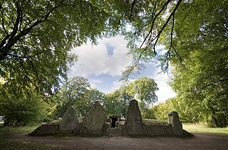
The West Kennet Long Barrow, also known as South Long Barrow, is a chambered long barrow near the village of Avebury in the south-western English county of Wiltshire. Probably constructed in the thirty-seventh century BC, during Britain's Early Neolithic period, today it survives in a partially reconstructed state.

Windmill Hill, Avebury Archaeological type site in England

Windmill Hill is a Neolithic causewayed enclosure in the English county of Wiltshire, part of the Avebury World Heritage Site, about 1 mile (2 km) northwest of Avebury. Enclosing an area of 21 acres (8.5 ha), it is the largest known causewayed enclosure in Britain. The site was first occupied around 3800 BC, although the only evidence is a series of pits apparently dug by an agrarian society using Hembury pottery.

Long barrow Type of dolmen

Long barrows are a style of monument constructed across Western Europe in the fifth and fourth millennia BCE, during the Early Neolithic period. Typically constructed from earth and either timber or stone, those using the latter material represent the oldest widespread tradition of stone construction in the world. Around 40,000 long barrows survive today.

Coldrum Long Barrow Neolithic chambered long barrow near Trottiscliffe, Kent, England

The Coldrum Long Barrow, also known as the Coldrum Stones and the Adscombe Stones, is a chambered long barrow located near the village of Trottiscliffe in the south-eastern English county of Kent. Probably constructed in the fourth millennium BCE, during Britain's Early Neolithic period, today it survives only in a state of ruin.

An oval barrow is the name given by archaeologists to a type of prehistoric burial tumulus of roughly oval shape.

Medway Megaliths Group of long barrows in Kent, England

The Medway Megaliths, sometimes termed the Kentish Megaliths, are a group of Early Neolithic chambered long barrows and other megalithic monuments located in the lower valley of the River Medway in Kent, South-East England. Constructed from local sarsen stone and soil between the 4th and 3rd millennia BCE, they represent the only known prehistoric megalithic group in eastern England and the most south-easterly group in Britain.

Coffin Stone Archaeological artifact in Kent, England

The Coffin Stone, also known as the Coffin and the Table Stone, is a large sarsen stone at the foot of Blue Bell Hill near Aylesford in the south-eastern English county of Kent. Now lying horizontally, the stone probably once stood upright nearby. Various archaeologists have argued that the stone was part of a now-destroyed chambered long barrow constructed in the fourth millennium BCE, during Britain's Early Neolithic period.

Smythes Megalith Neolithic monument in Kent, England

Smythe's Megalith, also known as the Warren Farm Chamber, was a chambered long barrow near the village of Aylesford in the south-eastern English county of Kent. Probably constructed in the 4th millennium BCE, during Britain's Early Neolithic period, it was discovered in 1822, at which point it was dismantled. Built out of earth and at least five local sarsen megaliths, the long barrow consisted of a roughly rectangular earthen tumulus with a stone chamber in its eastern end. Human remains were deposited into this chamber.

Chestnuts Long Barrow Chambered long barrow in Kent, England

Chestnuts Long Barrow, also known as Stony Warren or Long Warren, is a chambered long barrow near the village of Addington in the south-eastern English county of Kent. Probably constructed in the fifth millennium BC, during Britain's Early Neolithic period, today it survives only in a ruined state.

Addington Long Barrow Chambered long barrow in Kent, England

Addington Long Barrow is a chambered long barrow located near the village of Addington in the southeastern English county of Kent. Probably constructed in the fourth millennium BCE, during Britain's Early Neolithic period, today it survives only in a ruined state. Built of earth and about fifty local sarsen megaliths, the long barrow consisted of a sub-rectangular earthen tumulus enclosed by kerb-stones. Collapsed stones on the northeastern end of the chamber probably once formed a stone chamber in which human remains might have been deposited, though none have been discovered.

Julliberries Grave Long barrow in Kent, England

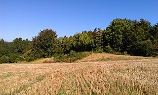
Julliberrie's Grave, also known as The Giant's Grave or The Grave, is an unchambered long barrow located near to the village of Chilham in the south-eastern English county of Kent. Probably constructed in the fourth millennium BCE, during Britain's Early Neolithic period, today it survives only in a state of ruin.

Badshot Lea Human settlement in England

Badshot Lea is a small village in Surrey, England, and close to Aldershot. Badshot Lea has access in either direction to the A31 and A331 and is connected to railway stations in the nearby towns with regular bus services. The village is part of the Blackwater Valley or Aldershot Urban Area, the thirtieth largest conurbation in the UK. Badshot Lea's boundaries are four bridges—three western railway bridges and Pea Bridge over the uppermost part of the River Blackwater— these inspired a logo for the village and the football team who play in the larger neighbouring village of Ash. The Blackwater separates Badshot Lea from Aldershot to the north; the eastern and western boundaries are short and the southern boundary is the A331.

Whitehawk Camp Remains of 5500-year-old causewayed enclosure

Whitehawk Camp is the remains of a causewayed enclosure on Whitehawk Hill near Brighton, East Sussex, England. Causewayed enclosures are a form of early Neolithic earthwork that were built in England from shortly before 3700 BC until at least 3500 BC, characterized by the full or partial enclosure of an area with ditches that are interrupted by gaps, or causeways. Their purpose is not known; they may have been settlements, or meeting places, or ritual sites. The Whitehawk site consists of four roughly concentric circular ditches, with banks of earth along the interior of the ditches evident in some places. There may have been a timber palisade on top of the banks. Outside the outermost circuit there are at least two more ditches, one of which is thought from radiocarbon evidence to date to the Bronze Age, about two thousand years after the earliest dated activity at the site.

Knap Hill Earthwork in Wiltshire, England

Knap Hill lies on the northern rim of the Vale of Pewsey, in northern Wiltshire, England, about a mile north of the village of Alton Priors. At the top of the hill is a causewayed enclosure, a form of Neolithic earthwork that was constructed in England from about 3700 BC onwards, characterized by the full or partial enclosure of an area with ditches that are interrupted by gaps, or causeways. Their purpose is not known—they may have been settlements, or meeting places, or ritual sites of some kind. The site has been scheduled as an ancient monument.

Hampton Down Stone Circle Bronze Age construction in Dorset, England

The Hampton Down Stone Circle is a stone circle located near to the village of Portesham in the south-western English county of Dorset. Archaeologists believe that it was likely erected during the Bronze Age. The Hampton Down ring is part of a tradition of stone circle construction that spread throughout much of Britain, Ireland, and Brittany during the Late Neolithic and Early Bronze Age, over a period between 3,300 and 900 BCE. The purpose of such monuments is unknown, although archaeologists speculate that they were likely religious sites, with the stones perhaps having supernatural associations for those who built the circles. However, it has been suggested that the site is not a stone circle at all, but is instead made up of kerbstones from a Bronze Age round barrow.

Shrubs Wood Long Barrow English long barrow

Shrub's Wood Long Barrow is an unchambered long barrow located near to the village of Elmsted in the south-eastern English county of Kent. It was probably constructed in the fourth millennium BCE, during Britain's Early Neolithic period. Built out of earth, the long barrow consists of a sub-trapezoidal tumulus flanked by side ditches.

Jackets Field Long Barrow Neolithic long barrow in Kent, England

Jacket's Field Long Barrow is an unchambered long barrow located near to the village of Boughton Aluph in the south-eastern English county of Kent. It was probably constructed in the fourth millennium BCE, during Britain's Early Neolithic period. Built out of earth, the long barrow consists of a sub-trapezoidal tumulus flanked by side ditches.

Preston Candover Long Barrow is an unchambered long barrow located near to the village of Preston Candover in the south-eastern English county of Hampshire.

References

Notes

  1. Rankine was largely a specialist in the study of Mesolithic Britain; he explored various fields around Farnham and Tilford during the 1930s, identifying prehistoric flint tools. [6]

Footnotes

  1. 1 2 Field & Cotton 1987, p. 81.
  2. Keiller & Piggott 1939, p. 133; Jessup 1970, p. 81.
  3. 1 2 Jessup 1970, p. 81.
  4. 1 2 3 4 5 Field & Cotton 1987, p. 79.
  5. Field & Cotton 1987, p. 133.
  6. 1 2 3 Field & Cotton 1987, p. 71.
  7. Keiller & Piggott 1939, p. 139; Jessup 1970, p. 81; Field & Cotton 1987, p. 80.
  8. Keiller & Piggott 1939, pp. 139–140.
  9. Keiller & Piggott 1939, p. 140; Jessup 1970, p. 81.
  10. 1 2 Field & Cotton 1987, p. 80.
  11. Kinnes 1992, p. 13.
  12. 1 2 Field & Cotton 1987, p. 73.
  13. Keiller & Piggott 1939, pp. 135–136; Jessup 1970, p. 81.
  14. Keiller & Piggott 1939, p. 137; Field & Cotton 1987, p. 79.
  15. 1 2 3 4 5 6 Keiller & Piggott 1939, p. 136.
  16. Keiller & Piggott 1939, p. 135; Field & Cotton 1987, p. 79.
  17. Keiller & Piggott 1939, pp. 136–137.
  18. 1 2 3 4 5 Keiller & Piggott 1939, p. 138.
  19. 1 2 Keiller & Piggott 1939, p. 136; Field & Cotton 1987, p. 79.
  20. Keiller & Piggott 1939, p. 136; Jessup 1970, p. 81.
  21. Keiller & Piggott 1939, pp. 138, 140.
  22. 1 2 Keiller & Piggott 1939, p. 142.
  23. Keiller & Piggott 1939, pp. 143–144.
  24. Keiller & Piggott 1939, p. 146; Field & Cotton 1987, p. 89.
  25. Keiller & Piggott 1939, pp. 14–15.
  26. Keiller & Piggott 1939, pp. 142–143.
  27. Keiller & Piggott 1939, pp. 144, 146.
  28. Keiller & Piggott 1939, p. 144.
  29. 1 2 Field & Cotton 1987, pp. 79–80.
  30. 1 2 Keiller & Piggott 1939, p. 133.
  31. 1 2 3 4 5 Keiller & Piggott 1939, p. 135.
  32. Keiller & Piggott 1939.
  33. "Neolithic Pot". Guildford Borough.

Bibliography

  • Ashbee, Paul (1970). The Earthen Long Barrow in Britain. London: J. M. Bent and Sons. ISBN   978-0460077552.
  • Field, David; Cotton, Jonathan (1987). "Neolithic Surrey: A Survey of the Evidence". In Joanna Bird; D. G. Bird (eds.). The Archaeology of Surrey to 1540. Guildford: Surrey Archaeological Society. pp. 71–96. ISBN   978-0950134567.
  • Grinsell, Leslie V. (1953). The Ancient Burial-Mounds of England (second ed.). London: Methuen & Co.
  • Hutton, Ronald (1991). The Pagan Religions of the Ancient British Isles: Their Nature and Legacy . Oxford and Cambridge: Blackwell. ISBN   978-0-631-17288-8.
  • Hutton, Ronald (2013). Pagan Britain. New Haven and London: Yale University Press. ISBN   978-0-300-197716.
  • Jessup, Ronald F. (1970). South-East England . London: Thames and Hudson. ISBN   978-0500020685.
  • Keiller, Alexander; Piggott, Stuart (1939). "Badshot Long Barrow (Report on the Excavations)". In Oakley, K. P.; W. F. Rankine; A. W. G. Lowther (eds.). A Survey of the Prehistory of the Farnham District (Surrey). Guildford: Surrey Archaeological Society. pp. 133–152.
  • Kinnes, Ian (1992). Non-Megalithic Long Barrows and Allied Structures in the British Neolithic. British Museum Occasional Papers No. 52. London: British Museum. ISBN   978-0861590520.
  • Malone, Caroline (2001). Neolithic Britain and Ireland. Stroud: Tempus. ISBN   0-7524-1442-9.

Coordinates: 51°13′27″N0°46′07″W / 51.22408°N 0.76871°W / 51.22408; -0.76871