Bagnell, Missouri

Last updated

Bagnell, Missouri
Miller County Missouri Incorporated and Unincorporated areas Bagnell Highlighted.svg
Location in Miller County and the state of Missouri
Coordinates: 38°13′46″N92°36′19″W / 38.22944°N 92.60528°W / 38.22944; -92.60528
Country United States
State Missouri
County Miller
Area
[1]
  Total0.60 sq mi (1.55 km2)
  Land0.47 sq mi (1.22 km2)
  Water0.13 sq mi (0.33 km2)
Elevation
[2]
581 ft (177 m)
Population
 (2020) [3]
  Total43
  Density91.49/sq mi (35.34/km2)
Time zone UTC-6 (Central (CST))
  Summer (DST) UTC-5 (CDT)
ZIP code
65026 (Eldon)
Area code 573
FIPS code 29-02962 [4]
GNIS feature ID2396583 [2]

Bagnell is a town in Miller County, Missouri, United States. [2] The population was 43 at the 2020 census, [3] down from 93 in 2010.

Contents

History

Bagnell was platted in 1882, when the railroad was extended through the area. [5] The town was named after William Bagnell of St. Louis County, who operated a tie business along the Osage River. [6] A post office called Bagnell was established in 1884, and remained in operation until 1942. [7]

Geography

Bagnell is in western Miller County, on the north side of Little Gravois Creek where it enters the Osage River, which forms the eastern border of the town. It is bordered to the southwest by the city of Lake Ozark. Bagnell is accessible by County Highway V, which leads 1 mile (2 km) southeast from U.S. Route 54 to the center of town. The city of Eldon is 9 miles (14 km) to the north, while Osage Beach is 6 miles (10 km) to the south. Bagnell Dam, which forms the Lake of the Ozarks on the Osage River, is 2 miles (3 km) southwest of Bagnell.

According to the U.S. Census Bureau, Bagnell has a total area of 0.60 square miles (1.55 km2), of which 0.47 square miles (1.22 km2) are land and 0.13 square miles (0.34 km2), or 21.5%, are water. [1]

Demographics

Historical population
CensusPop.Note
1930 449
1940 118−73.7%
1950 74−37.3%
1960 62−16.2%
1970 60−3.2%
1980 7118.3%
1990 8925.4%
2000 86−3.4%
2010 938.1%
2020 43−53.8%
U.S. Decennial Census [8]

2010 census

At the 2010 census there were 93 people in 43 households, including 24 families, in the town. The population density was 197.9 inhabitants per square mile (76.4/km2). There were 60 housing units at an average density of 127.7 per square mile (49.3/km2). The racial makeup of the town was 94.6% White and 5.4% from two or more races. [9]

Of the 43 households, 32.6% had children under the age of 18 living with them, 34.9% were married couples living together, 16.3% had a female householder with no husband present, 4.7% had a male householder with no wife present, and 44.2% were non-families. 32.6% of households were one person, and 4.6% were one person aged 65 or older. The average household size was 2.16 and the average family size was 2.71.

The median age was 42.3 years. 23.7% of residents were under the age of 18; 8.6% were between the ages of 18 and 24; 27% were from 25 to 44; 34.4% were from 45 to 64; and 6.5% were 65 or older. The gender makeup of the town was 49.5% male and 50.5% female.

2000 census

At the 2000 census there were 86 people, 36 households, and 20 families in the town. The population density was 183.3 inhabitants per square mile (70.8/km2). There were 37 housing units at an average density of 78.9 per square mile (30.5/km2). The racial makeup of the town was 96.51% White and 3.49% Native American. Hispanic or Latino of any race were 1.16%. [4]

Of the 36 households, 30.6% had children under the age of 18 living with them, 38.9% were married couples living together, 11.1% had a female householder with no husband present, and 41.7% were non-families. 38.9% of households were one person, and 22.2% were one person aged 65 or older. The average household size was 2.39 and the average family size was 3.00.

In the town the population was spread out, with 27.9% under the age of 18, 9.3% from 18 to 24, 29.1% from 25 to 44, 20.9% from 45 to 64, and 12.8% 65 or older. The median age was 36 years. For every 100 females there were 95.5 males. For every 100 females age 18 and over, there were 100.0 males.

The median household income was $25,313 and the median family income was $27,857. Males had a median income of $22,083 versus $16,563 for females. The per capita income for the town was $14,633. There were no families and 2.2% of the population living below the poverty line, including no under eighteens and 11.1% of those over 64.

Related Research Articles

<span class="mw-page-title-main">Chetopa, Kansas</span> City in Labette County, Kansas

Chetopa is a city in Labette County, Kansas, United States. As of the 2020 census, the population of the city was 929. Chetopa was named for Chief Chetopah, an Osage Indian chief. Later, the community name was shortened.

<span class="mw-page-title-main">Warsaw, Missouri</span> City in Missouri, United States

Warsaw is a city located in Benton County, Missouri, United States. The population was 2,209 at the 2020 census. Warsaw is the county seat of Benton County.

<span class="mw-page-title-main">Linn Creek, Missouri</span> City in Missouri, United States

Linn Creek is a city in Camden County, Missouri, United States. The population was 216 at the 2020 census.

<span class="mw-page-title-main">Lakeside, Missouri</span> Inactive City in Missouri, United States

Lakeside is an inactive city in Miller County, Missouri, United States, located along the Osage River near the Bagnell Dam. The population was 37 at the 2000 census. However, As of the 2020 census, the city's population was 0, with only one housing unit.

<span class="mw-page-title-main">St. Elizabeth, Missouri</span> Village in Missouri, United States

St. Elizabeth or Saint Elizabeth is a village in Miller County, Missouri, United States. The population was 336 at the 2010 census.

<span class="mw-page-title-main">Tuscumbia, Missouri</span> Town in Missouri, United States

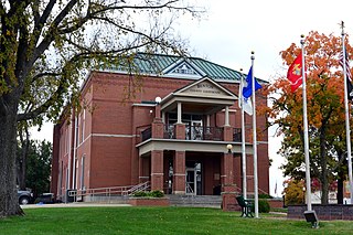
Tuscumbia is a village in and the county seat of Miller County, Missouri, United States. The population was 203 at the 2010 census, at which time it was a town.

<span class="mw-page-title-main">Freeburg, Missouri</span> Village in Missouri, United States

Freeburg is a village in Osage County, Missouri, United States. The population was 409 at the 2020 census. It is part of the Jefferson City, Missouri Metropolitan Statistical Area.

<span class="mw-page-title-main">Linn, Missouri</span> City in Missouri, United States

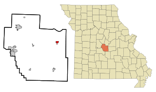
Linn is a city in Osage County, Missouri, United States. The population was 1,350 at the 2020 census. It is the county seat of Osage County. Linn is part of the Jefferson City, Missouri Metropolitan Statistical Area.

<span class="mw-page-title-main">Meta, Missouri</span> City in Missouri, United States

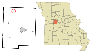
Meta is a city in Osage County, Missouri, United States. The population was 180 at the 2020 census. It is part of the Jefferson City, Missouri Metropolitan Statistical Area and is also the world headquarters of Diamond Pet Foods.

<span class="mw-page-title-main">Houstonia, Missouri</span> City in Missouri, United States

Houstonia is a city in northwest Pettis County, Missouri, United States. The population was 220 at the 2010 census.

<span class="mw-page-title-main">Grand Pass, Missouri</span> Village in Missouri, United States

Grand Pass is a village in Saline County, Missouri, United States. The population was 66 at the 2010 census.

<span class="mw-page-title-main">Osceola, Missouri</span> City in Missouri, United States

Osceola is a city in St. Clair County, Missouri, United States. The population was 909 at the 2020 census. It is the county seat of St. Clair County. During the American Civil War, Osceola was the site of the Sacking of Osceola.

<span class="mw-page-title-main">Metz, Missouri</span> Village in Missouri, United States

Metz is a village in Vernon County, Missouri, United States. The population was 49 at the 2010 census, at which time it was a town.

<span class="mw-page-title-main">Nevada, Missouri</span> City in Missouri, United States

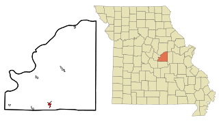
Nevada is a city in and the county seat of Vernon County, Missouri, United States. The population was 8,386 at the 2010 census, and 8,254 in the 2018 estimate. The local government has a council-manager model.

<span class="mw-page-title-main">Schell City, Missouri</span> City in Missouri, United States

Schell City is a city in northeast Vernon County, Missouri, United States. The population was 249 at the 2010 census.

<span class="mw-page-title-main">Stotesbury, Missouri</span> Village in Missouri, United States

Stotesbury is a village in northwest Vernon County, Missouri, United States. The population was 18 at the 2010 census.

<span class="mw-page-title-main">Lake Ozark, Missouri</span> City in Missouri, United States

Lake Ozark is a city in Camden and Miller counties in the U.S. state of Missouri, near its namesake, the Lake of the Ozarks. The population was 2,077 at the 2020 census.

<span class="mw-page-title-main">Osage Beach, Missouri</span> City in Missouri, United States

Osage Beach is a city in Camden and Miller counties in the U.S. state of Missouri, near the Lake of the Ozarks. Most of the city is in Camden County, while a small eastern sliver is in Miller County. The population was 4,792 at the 2020 census.

<span class="mw-page-title-main">Argyle, Missouri</span> Town in Missouri, United States

Argyle is a town in Osage and Maries counties in the U.S. state of Missouri. The population was 144 at the 2020 census.

<span class="mw-page-title-main">Belle, Missouri</span> City in Missouri, United States

Belle is a city in northeast Maries County and extending north into southeast Osage County in the U.S. state of Missouri. The population was 1,381 at the 2020 census, down from 1,545 in 2010.

References

  1. 1 2 "2023 U.S. Gazetteer Files: Missouri". United States Census Bureau. Retrieved April 15, 2024.
  2. 1 2 3 U.S. Geological Survey Geographic Names Information System: Bagnell, Missouri
  3. 1 2 "P1. Race – Bagnell town, Missouri: 2020 DEC Redistricting Data (PL 94-171)". U.S. Census Bureau. Retrieved April 15, 2024.
  4. 1 2 "U.S. Census website". United States Census Bureau . Retrieved January 31, 2008.
  5. "Miller County Place Names, 1928–1945". State Historical Society of Missouri. Archived from the original on June 24, 2016. Retrieved November 6, 2016.
  6. Eaton, David Wolfe (1916). How Missouri Counties, Towns and Streams Were Named. The State Historical Society of Missouri. pp.  194.
  7. "Post Offices". Jim Forte Postal History. Retrieved November 6, 2016.
  8. "Census of Population and Housing". Census.gov. Retrieved June 4, 2015.
  9. "U.S. Census website". United States Census Bureau . Retrieved July 8, 2012.