Bainville, Montana

Last updated

Bainville, Montana
Roosevelt County Montana Incorporated and Unincorporated areas Bainville Highlighted.svg
Location of Bainville, Montana
Coordinates: 48°8′26″N104°13′15″W / 48.14056°N 104.22083°W / 48.14056; -104.22083
Country United States
State Montana
County Roosevelt
Area
[1]
  Total1.26 sq mi (3.27 km2)
  Land1.26 sq mi (3.27 km2)
  Water0.00 sq mi (0.00 km2)
Elevation
1,975 ft (602 m)
Population
 (2020)
  Total271
  Density214.40/sq mi (82.76/km2)
Time zone UTC-7 (Mountain (MST))
  Summer (DST) UTC-6 (MDT)
ZIP code
59212
Area code 406
FIPS code 30-03400
GNIS feature ID0802007

Bainville is a town in Roosevelt County, Montana, United States. The population was 271 at the 2020 census. [2] It is named for Charles M. Bain, an early resident and the town's first postmaster. [3] Bainville celebrated its centennial on July 4, 2006.

Contents

Geography

Bainville is located at 48°8′26″N104°13′15″W / 48.14056°N 104.22083°W / 48.14056; -104.22083 (48.140470, -104.220900). [4]

According to the United States Census Bureau, the town has a total area of 1.02 square miles (2.64 km2), all land. [5]

Demographics

Historical population
CensusPop.Note
1920 396
1930 47118.9%
1940 403−14.4%
1950 356−11.7%
1960 285−19.9%
1970 217−23.9%
1980 24512.9%
1990 165−32.7%
2000 153−7.3%
2010 20835.9%
2020 27130.3%
U.S. Decennial Census [2]

2010 census

As of the census [6] of 2010, there were 208 people, 85 households, and 52 families living in the town. The population density was 203.9 inhabitants per square mile (78.7/km2). There were 95 housing units at an average density of 93.1 per square mile (35.9/km2). The racial makeup of the town was 85.6% White, 11.1% Native American, and 3.4% from two or more races. Hispanic or Latino of any race were 0.5% of the population.

There were 85 households, of which 38.8% had children under the age of 18 living with them, 48.2% were married couples living together, 7.1% had a female householder with no husband present, 5.9% had a male householder with no wife present, and 38.8% were non-families. 34.1% of all households were made up of individuals, and 11.8% had someone living alone who was 65 years of age or older. The average household size was 2.45 and the average family size was 3.17.

The median age in the town was 30.8 years. 34.1% of residents were under the age of 18; 4.9% were between the ages of 18 and 24; 25.9% were from 25 to 44; 24.1% were from 45 to 64; and 11.1% were 65 years of age or older. The gender makeup of the town was 52.4% male and 47.6% female.

2000 census

As of the census<"wwwcensusgov"/> of 2000, there were 153 people, 72 households, and 43 families living in the town. The population density was 147.9 inhabitants per square mile (57.1/km2). There were 83 housing units at an average density of 80.2 per square mile (31.0/km2). The racial makeup of the town was 89.54% White, 5.23% Native American, and 5.23% from two or more races. Hispanic or Latino of any race were 0.65% of the population.

There were 72 households, out of which 23.6% had children under the age of 18 living with them, 54.2% were married couples living together, 4.2% had a female householder with no husband present, and 38.9% were non-families. 37.5% of all households were made up of individuals, and 22.2% had someone living alone who was 65 years of age or older. The average household size was 2.13 and the average family size was 2.82.

In the town, the population was spread out, with 19.6% under the age of 18, 5.9% from 18 to 24, 19.6% from 25 to 44, 28.1% from 45 to 64, and 26.8% who were 65 years of age or older. The median age was 49 years. For every 100 females there were 82.1 males. For every 100 females age 18 and over, there were 86.4 males.

The median income for a household in the town was $26,250, and the median income for a family was $29,643. Males had a median income of $27,000 versus $13,750 for females. The per capita income for the town was $14,997. About 16.7% of families and 14.8% of the population were below the poverty line, including 18.4% of those under the age of eighteen and 9.1% of those 65 or over.

Transportation

Amtrak’s Empire Builder, which operates between Seattle/Portland and Chicago, passes through the town on BNSF tracks, but makes no stop. The nearest station is located in Williston, 28 miles (45 km) to the east.

Education

Bainville Public School educates students from kindergarten through 12th grade. [7] Bainville High School is known as the Bulldogs. [8]

See also

Related Research Articles

<span class="mw-page-title-main">Selbyville, Delaware</span> Town in Delaware, United States

Selbyville is a town in Sussex County, Delaware, United States. Its population was 2,167 at the 2010 census, an increase of 31.7% over the previous decade. It is part of the Salisbury, Maryland-Delaware Metropolitan Statistical Area.

<span class="mw-page-title-main">Ludlow, Maine</span> Town in the state of Maine, United States

Ludlow is a town in Aroostook County, Maine, United States. The population was 434 at the 2020 census.

<span class="mw-page-title-main">Strong, Maine</span> Town in Maine, United States

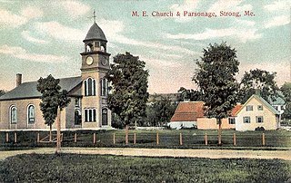
Strong is a town in Franklin County, Maine, United States. The population was 1,122 at the 2020 census. Strong is home to the annual Sandy River Festival.

Palmyra is a town in Somerset County, Maine, United States. The population was 1,924 at the 2020 census.

<span class="mw-page-title-main">Yarmouth Port, Massachusetts</span> Census-designated place in Massachusetts, United States

Yarmouth Port is a census-designated place (CDP) in the town of Yarmouth in Barnstable County, Massachusetts, United States. The population was 5,320 at the 2010 census.

<span class="mw-page-title-main">Bridger, Montana</span> Town in Montana, United States

Bridger is a town in Carbon County, Montana, United States. It is part of the Billings, Montana Metropolitan Statistical Area. The population was 662 at the 2020 census.

<span class="mw-page-title-main">Flaxville, Montana</span> Town in Montana, United States

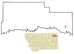
Flaxville is a town in Daniels County, Montana, United States. The population was 63 at the 2020 census.

<span class="mw-page-title-main">Grass Range, Montana</span> Town in Montana, United States

Grass Range is a town in Fergus County, Montana, United States. The population was 110 in both the 2010 census and 2020 census.

<span class="mw-page-title-main">Rexford, Montana</span> Town in Montana, United States

Rexford is a town in Lincoln County, Montana, United States. The population was 78 at the 2020 census.

<span class="mw-page-title-main">Brockton, Montana</span> Census-designated place in Montana, United States

Brockton is a census-designated place and former town in Roosevelt County, Montana, United States. The population was 358 at the 2020 census.

<span class="mw-page-title-main">Antelope, Montana</span> CDP in Montana, United States

Antelope is a census-designated place (CDP) in Sheridan County, Montana, United States. The population was 51 at the 2010 census.

<span class="mw-page-title-main">Outlook, Montana</span> Town in Montana, United States

Outlook is a small rural village in Sheridan County, Montana, United States. The population was 84 at the 2020 census. The village includes a post office which services Outlook and the hamlet of Raymond, as well as the surrounding countryside.

<span class="mw-page-title-main">Westby, Montana</span> Town in Montana, United States

Westby is a town in Sheridan County, Montana, United States. The population was 167 at the 2020 census.

<span class="mw-page-title-main">Kevin, Montana</span> Town in Montana, United States

Kevin is a town in Toole County, Montana, United States. The population was 154 at the 2020 census, equal to the 2010 Census population. The town was named after Thomas Kevin, superintendent of the Alberta Railway & Irrigation Company. Locals pronounce Kevin with a long E, like Keevin.

<span class="mw-page-title-main">Denton, Montana</span> Town in Fergus County, Montana, United States

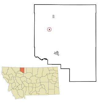
Denton is a town in Fergus County, Montana, United States. The population was 205 at the 2020 census.

<span class="mw-page-title-main">Batesland, South Dakota</span> Town in South Dakota, United States

Batesland is a town in Oglala Lakota County, South Dakota, United States. The population was 100 at the 2020 census.

<span class="mw-page-title-main">Durbin, West Virginia</span> Town in West Virginia, United States

Durbin is a town in Pocahontas County, West Virginia, United States. The population was 235 at the 2020 census.

<span class="mw-page-title-main">Medary, Wisconsin</span> Town in Wisconsin, United States

Medary is a town in La Crosse County, Wisconsin, United States. The population was 1,461 at the 2010 census. It is part of the La Crosse, Wisconsin Metropolitan Statistical Area. The unincorporated community of Medary is located in the town.

<span class="mw-page-title-main">Yoder, Wyoming</span> Town in Wyoming, United States

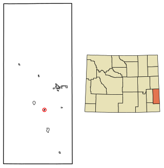
Yoder is a town in Goshen County, Wyoming, United States. The population was 131 at the 2020 census.

<span class="mw-page-title-main">Blue Mounds (town), Wisconsin</span> Town in Wisconsin, United States

Blue Mounds is a town in Dane County, Wisconsin, United States. The population was 899 at the 2020 census. The Village of Blue Mounds is located within the town.

References

  1. "ArcGIS REST Services Directory". United States Census Bureau. Retrieved September 5, 2022.
  2. 1 2 "U.S. Census website". United States Census Bureau . Retrieved November 2, 2021.
  3. "Montana Place Names". Archived from the original on September 27, 2007. Retrieved September 12, 2007.
  4. "US Gazetteer files: 2010, 2000, and 1990". United States Census Bureau. February 12, 2011. Retrieved April 23, 2011.
  5. "US Gazetteer files 2010". United States Census Bureau. Archived from the original on January 25, 2012. Retrieved December 18, 2012.
  6. "U.S. Census website". United States Census Bureau . Retrieved October 2, 2021.
  7. "Bainville Public School". Bainville Public School. Retrieved April 19, 2021.
  8. "Member Schools". Montana High School Association. Retrieved April 19, 2021.