
A glacier is a persistent body of dense ice that is constantly moving under its own weight. A glacier forms where the accumulation of snow exceeds its ablation over many years, often centuries. It acquires distinguishing features, such as crevasses and seracs, as it slowly flows and deforms under stresses induced by its weight. As it moves, it abrades rock and debris from its substrate to create landforms such as cirques, moraines, or fjords. Although a glacier may flow into a body of water, it forms only on land and is distinct from the much thinner sea ice and lake ice that form on the surface of bodies of water.

A floodplain or flood plain or bottomlands is an area of land adjacent to a river. Floodplains stretch from the banks of a river channel to the base of the enclosing valley, and experience flooding during periods of high discharge. The soils usually consist of clays, silts, sands, and gravels deposited during floods.
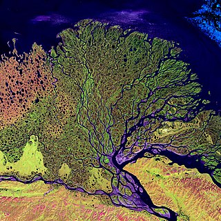
A river delta is a landform shaped like a triangle, created by the deposition of sediment that is carried by a river and enters slower-moving or stagnant water. This occurs at a river mouth, when it enters an ocean, sea, estuary, lake, reservoir, or another river that cannot carry away the supplied sediment. It is so named because its triangle shape resembles the uppercase Greek letter delta, Δ. The size and shape of a delta are controlled by the balance between watershed processes that supply sediment, and receiving basin processes that redistribute, sequester, and export that sediment. The size, geometry, and location of the receiving basin also plays an important role in delta evolution.

Gravel is a loose aggregation of rock fragments. Gravel occurs naturally on Earth as a result of sedimentary and erosive geological processes; it is also produced in large quantities commercially as crushed stone.
Alluvium is loose clay, silt, sand, or gravel that has been deposited by running water in a stream bed, on a floodplain, in an alluvial fan or beach, or in similar settings. Alluvium is also sometimes called alluvial deposit. Alluvium is typically geologically young and is not consolidated into solid rock. Sediments deposited underwater, in seas, estuaries, lakes, or ponds, are not described as alluvium.

In geology, a placer deposit or placer is an accumulation of valuable minerals formed by gravity separation from a specific source rock during sedimentary processes. The name is from the Spanish word placer, meaning "alluvial sand". Placer mining is an important source of gold, and was the main technique used in the early years of many gold rushes, including the California Gold Rush. Types of placer deposits include alluvium, eluvium, beach placers, aeolian placers and paleo-placers.

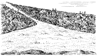
An alluvial fan is an accumulation of sediments that fans outwards from a concentrated source of sediments, such as a narrow canyon emerging from an escarpment. They are characteristic of mountainous terrain in arid to semiarid climates, but are also found in more humid environments subject to intense rainfall and in areas of modern glaciation. They range in area from less than 1 square kilometer (0.4 sq mi) to almost 20,000 square kilometers (7,700 sq mi).

Placer mining is the mining of stream bed (alluvial) deposits for minerals. This may be done by open-pit or by various surface excavating equipment or tunneling equipment.
Landforms are categorized by characteristic physical attributes such as their creating process, shape, elevation, slope, orientation, rock exposure, and soil type.

Wadi, alternatively wād, Maghrebi Arabic Oued, Hebrew: וָאדִי, romanized: wadi, lit. 'wadi') is the Arabic term traditionally referring to a river valley. In some instances, it may refer to a wet (ephemeral) riverbed that contains water only when heavy rain occurs.

Conglomerate is a clastic sedimentary rock that is composed of a substantial fraction of rounded to subangular gravel-size clasts. A conglomerate typically contains a matrix of finer-grained sediments, such as sand, silt, or clay, which fills the interstices between the clasts. The clasts and matrix are typically cemented by calcium carbonate, iron oxide, silica, or hardened clay.
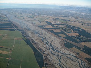
An alluvial plain is a plain created by the deposition of sediment over a long period of time by one or more rivers coming from highland regions, from which alluvial soil forms. A floodplain is part of the process, being the smaller area over which the rivers flood at a particular period of time, whereas the alluvial plain is the larger area representing the region over which the floodplains have shifted over geological time.
Parent material is the underlying geological material in which soil horizons form. Soils typically inherit a great deal of structure and minerals from their parent material, and, as such, are often classified based upon their contents of consolidated or unconsolidated mineral material that has undergone some degree of physical or chemical weathering and the mode by which the materials were most recently transported.

Upland and lowland are conditional descriptions of a plain based on elevation above sea level. In studies of the ecology of freshwater rivers, habitats are classified as upland or lowland.

A crevasse splay is a sedimentary fluvial deposit which forms when a stream breaks its natural or artificial levees and deposits sediment on a floodplain. A breach that forms a crevasse splay deposits sediments in similar pattern to an alluvial fan deposit. Once the levee has been breached the water flows out of its channel. As the water spreads onto the flood plain sediments will start to fall out of suspension as the water loses energy. The resulting deposition can create graded deposits similar to those found in Bouma sequences. In some cases crevasse splays can cause a river to abandon its old river channel, a process known as avulsion. Breaches that form a crevasse splay deposits occur most commonly on the outside banks of meanders where the water has the highest energy. Crevasse splay deposits can range in size. Larger deposits can be 6 m (20 ft) thick at the levee and spread 2 km (1.2 mi) wide, while smaller deposits may only be 1 cm (0.39 in) thick.

In geology, depositional environment or sedimentary environment describes the combination of physical, chemical, and biological processes associated with the deposition of a particular type of sediment and, therefore, the rock types that will be formed after lithification, if the sediment is preserved in the rock record. In most cases, the environments associated with particular rock types or associations of rock types can be matched to existing analogues. However, the further back in geological time sediments were deposited, the more likely that direct modern analogues are not available.

The Geology of Pennsylvania consists of six distinct physiographic provinces, three of which are subdivided into different sections. Each province has its own economic advantages and geologic hazards and plays an important role in shaping everyday life in the state. From the southeast corner to the northwest corner of the state, they include: the Atlantic Plain Province, the Piedmont Province, the New England Province, the Ridge and Valley Province, the Appalachain Province, and the Central Lowlands Province.
In hydrology, a debouch is a place where runoff from a small, confined space discharges into a larger, broader body of water. The word is derived from the French verb déboucher, which means "to unblock, to clear". The term also has a military usage.

A pediment, also known as a concave slope or waning slope, is a very gently sloping (0.5°–7°) inclined bedrock surface. It is typically a concave surface sloping down from the base of a steeper retreating desert cliff, escarpment, or surrounding a monadnock or inselberg, but may persist after the higher terrain has eroded away.
Tectonic forces have been shown to have major influences on alluvial fans. Tectonic movements such as tectonic uplift are driving factors in determining the development, shape, structure, size, location, and thickness of alluvial fans and influence the formation of segmented fans. By understanding the tectonic influences, the geologic history can be determined by taking information from an alluvial fan and determining the tectonic history of the region.


