Barpeta district {Pron:bə(r)ˈpeɪtə or bə(r)ˈpi:tə} is an administrative district in the state of Assam in India. The district headquarters are located at Barpeta. The district occupies an area of 3,245 km2 (1,253 sq mi) and has a population of 1,642,420.

Bongaigaon district (Prpn:ˈbɒŋgaɪˌgãʊ) is an administrative district in the state of Assam in northeastern India. The district headquarters are located at Bongaigaon. The district occupies an area of 1,093 km2.

Goalpara district is an administrative district of the Indian state of Assam.

Kokrajhar district is an administrative district in Bodoland Territorial Region of Assam. It is predominantly inhabited by the Boro tribe. The district has its headquarters located at Kokrajhar Town and occupies an area of 3,169.22 km2 (1,223.64 sq mi). It has two civil sub-divisions namely Parbatjhora and Gossaigaon and five revenue circles namely Kokrajhar, Dotma, Bhaoraguri, Gossaigaon and Bagribarilll

Kamrup Rural district, or simply Kamrup district, is an administrative district in the state of Assam in India formed by dividing the old Kamrup district into two in the year 2003; other being Kamrup Metropolitan district, named after the region it constitutes. This district, along with Nalbari, Barpeta, Kamrup Metropolitan, Bajali and Baksa districts has been created from the Undivided Kamrup district.

Nalbari is an administrative district in the state of Assam in India. The district headquarters is located at Nalbari. The district derives its name from the combination of two words, "Nal" and "Bar."

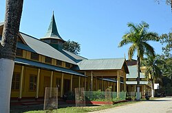
Barpeta is a town in Barpeta district of the state of Assam in India and is district headquarters. The city is located 90 kilometres (56 mi) north west of Guwahati and is one of the major cities in Western Assam. It is also called Satra Nagari of Assam due to the presence of various Vaishnavite Satras in the vicinity.
Dhemaji district is an administrative district in the state of Assam in India. The district headquarters are located at Dhemaji and commercial headquarters being located Silapathar. The district occupies an area of 3237 km² and has a population of 686,133. Main religions are Hindus 548,780, Muslims 10,533, Christians 6,390.
Chirang District is an administrative district in the Bodoland Territorial Region of Assam state in the North-East of India.

Baksa district is an administrative district in the Bodoland Territorial Region of Assam, one of the North-Eastern states of India. The administrative headquarters is at Mushalpur. Manas National Park is a part of this district.

Udalguri district (Pron:ˌʊdʌlˈgʊəri), also known as Odalguri, is a district in the Bodoland Territorial Region of the state of Assam in Northeastern India. Udalguri town is the headquarters of the district.

Kamrup Metropolitan district is one of the 35 districts in Assam state in north-eastern India. It was carved out of the erstwhile undivided Kamrup district in 2003 and covers an area equivalent to the area under the jurisdiction of the Guwahati Metropolitan Development Authority area. Dispur Legislative Assembly Constituency in Kamrup Metro district with 3.53 lakh voters is the largest constituency in Assam.

Lower Assam division is one of the 5 administrative divisions of Assam in India. It was formed in 1874, consisting of the undivided Kamrup district of Western Assam, undivided Darrang and Nagaon districts of Central Assam and Khasi & Jaintia hills of Meghalaya, created for revenue purposes. The division is under the jurisdiction of a Commissioner, who is stationed at Guwahati. The division currently covers the Western Brahmaputa Valley. Shri Jayant Narlikar, IAS is the current Commissioner of Lower Assam division.
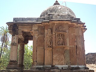
Mahisagar district is a district in the state of Gujarat in India that came into being on 26 January 2013, becoming the 28th district of the state. The district has been carved out of the Panchmahal district and the Kheda district. District Name Mahisagar given from "Mahi River". Lunawada is the district headquarters of Mahisagar. It started its operation in full-fledged from 15 August 2013.

Biswanath is an administrative district in the state of Assam in India. It is one of newly created district in the year by 2015, declared by Assam Chief Minister Tarun Gogoi on 15 August 2015.

Hojai District is a district in Assam, India. It was formed on 15 August 2015. The headquarters of the district is situated at Sankardev Nagar, which is about 8 km away from Hojai town. Hojai District was formed from three tehsils of Nagaon District, namely Hojai, Doboka and Lanka. Hojai was a part of undivided Nowgong district of then Assam Province.
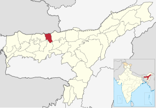
Tamulpur district, is an administrative district in Bodoland Territorial Region of Assam, one of the North-Eastern states of India. The administrative headquartered at Tamulpur.
The population of Assam consist of tribal ethnic groups and linguistic groups such as Assamese, Bengali, Hindi speakers, Nepali and Odia speakers.
Kekerikuchi is a census village in Tamulpur district, Assam, India. As per the 2011 Census of India, Kekerikuchi has a total population of 1,867 people including 927 males and 940 females.