Bakolori Dam

Last updated
Bakolori Dam
Bakolori Reservoir.jpg
Nigeria relief location map.jpg
Red pog.svg
Location of Bakolori Dam in Nigeria
Location Nigeria
Coordinates 12°30′43″N6°11′0″E / 12.51194°N 6.18333°E / 12.51194; 6.18333
Construction began1974
Opening date1978
Dam and spillways
Type of dam Earth-fill embankment
Impounds Sokoto River
Height48m
Length360m
Reservoir
Total capacity450,000,000 cu.m
Power Station
Installed capacity 11 MW

The Bakolori Dam is in Sokoto State in northwest Nigeria. It was completed in 1978 and its reservoir filled by 1981. It is a major reservoir on the Sokoto River, a tributary of the Rima River, which in turn feeds the Niger River. Water from the dam supplies the Bakolori Irrigation Project. [1]

Contents

The dam has a capacity of 450 million cubic meters, with a reservoir covering 8,000 hectares extending 19 km (12 mi) upstream. [2]

Dam construction displaced many peasant farmers without providing alternative land or financial compensation. Many people died in protests over their loss of livelihood. [3] The project has become known as a classic example of development failure. [4]

Background

The Sokoto River runs through the semi-arid Sudan Savannah zone of northern Nigeria. Annual rainfall is unpredictable, ranging from 500 mm to 1,300 mm per year during the JuneSeptember period. Before construction of the dam, about 50,000 farmers in the Sokoto River floodplain practiced intensive recession farming, growing rice and sorghum in the wet season and vegetable crops such as onions, garlic and tomatoes in the dry season. [1] Many farmers used the Shadoof practice of lifting water from the river to pour into irrigation channels or ponds. Women in purdah do not usually work the field but do have ownership rights and assist in processing. Women who are not under seclusion are active in farming. [2] Often the land was owned communally without formal records of ownership. [1]

Farmers in the area, living at subsistence levels, were more concerned with avoiding risk than maximizing profit. The area is subject to periodic droughts, and the desire for a stable water supply was one of the motives for constructing the dam. [1]

Planning

In 1969, the Food and Agriculture Organization (FAO) issued a report that recommended a small dam and irrigation scheme at Talata Mafara, with further upstream dams for flood control. The FAO report emphasized the importance of a gradual approach that would have minimal impact on existing land use patterns, in part because of lack of experience with irrigation projects in the region. In 1971 the Nigerian military government invited proposals for design and supervision of the project and, in 1972, awarded the job to Impressit Bakolori Nigeria, a company owned 60% by the Nigerian government and 40% by a subsidiary of Fiat. During the 1972 to 1974 study period, the scope of the project expanded to cover a single large dam and a large-scale mechanized irrigation scheme. Local farmers were not consulted in the planning process and no study was made of the downstream impact. [1]

Construction

Sokoto River Basin, showing the location of the dam Sokotorivermap.png
Sokoto River Basin, showing the location of the dam

Construction of the dam began in 1974 and was completed in 1978, after which it took three years for the reservoir to fill. The dam is a 5.5 km (3 mi) earth-fill embankment, with a central concrete structure 360 m long and 48 m high incorporating a small 3 MW hydroelectric power plant. The irrigation pipes and canals were not completed until 1983 and covered only 23,000 hectares compared to 30,000 hectares originally planned. Water was delivered to 15,000 hectares by sprinklers and to 8,000 hectares by gravity. Sprinklers are expensive but make more efficient use of water if well maintained. After cost overruns, the irrigation project ended up as one of the most expensive per hectare in the world. [1]

Construction of the dam, with land leveling, clearing and canal construction destroyed valuable farmland and trees. The local farmers became landless peasants. Most received no compensation, or were given worthless land. Those that stayed were forced to grow unfamiliar crops such as wheat. [2] During construction, the local farmers were deprived of the means to make a living for several years. Confronted by demonstrators in November 1979, the governor of Sokoto State, Shehu Kangiwa, promised to address all their grievances. However, on 28 April 1980 police moved in on unarmed demonstrators and killed over 380 people. The government played down the incident, claiming only 25 had died. [3]

Downstream impact

Sketch map of Sokoto River showing Bakolori Dam and irrigation project Bakolori Irrigation Project1.png
Sketch map of Sokoto River showing Bakolori Dam and irrigation project

The downstream floodplain farmers required large-scale water release before the growing season, with diminished flows later as they practiced flood recession agriculture. [5] Dam operators were not sensitive to this need, releasing insufficient water at inappropriate times. [6] The dam significantly decreased peak flows and the depth, duration and extent of flooding downstream during the wet season. [5] [7] It also reduced the total amount of water available for farming, since a large sheet of water in a hot and arid area loses much to evaporation. [2] In the downstream areas, of a total of 19,000 hectares of floodplain land, the dam resulted in loss of 7,000 hectares of rice production and 5,000 hectares of dry season crops. [7] This loss was partially offset by increases in lower-value millet and sorghum production, but 12,000 people were forced to move. [8] The loss of agricultural output has been valued at US$7 million annually. [9]

Reservoir and irrigation area

The reservoir has a relatively small littoral area, which limits the size of spawning and nursery areas of most fish species. The water is turbid, holding suspended soil particles that block the light and inhibit growth of submerged aquatic plants on which fish depend for food. This limits the capacity of the reservoir for fish production. [10] The reservoir is less productive than the river and the river's natural lakes and pools. [11] In the irrigated area, the higher water table combined with high evaporation rates has caused salinization, which has already ruined half of the irrigable land. There were also higher levels of water-born diseases. [2] Attempts to introduce new varieties of cowpea inter-cropped with millet, sorghum and groundnuts had little success due to the relatively low yield of this traditional crop and the high cost of the irrigation systems. [12]

By 2003, the sprinkler system was no longer operational and only 7,500 hectares were being cultivated, mostly for rice, using gravity-fed irrigation. [13] Land was left untilled. Many residents drifted away to the cities. [1] The Bakolori Dam resulted in a 53% decrease in the usable cropped area. [14]

The authors of a report on Wise Use of Wetlands published by UNESCO in 1988 concluded that "a more complete economic appraisal of the scheme at Bakolori would have been less favourable than the calculation upon which it was approved." [15]

Related Research Articles

<span class="mw-page-title-main">Irrigation</span> Agricultural artificial application of water to land

Irrigation is the practice of applying controlled amounts of water to land to help grow crops, landscape plants, and lawns. Irrigation has been a key aspect of agriculture for over 5,000 years and has been developed by many cultures around the world. Irrigation helps to grow crops, maintain landscapes, and revegetate disturbed soils in dry areas and during times of below-average rainfall. In addition to these uses, irrigation is also employed to protect crops from frost, suppress weed growth in grain fields, and prevent soil consolidation. It is also used to cool livestock, reduce dust, dispose of sewage, and support mining operations. Drainage, which involves the removal of surface and sub-surface water from a given location, is often studied in conjunction with irrigation.

<span class="mw-page-title-main">Aswan Dam</span> Dam in Aswan, Egypt

The Aswan Dam, or more specifically since the 1980s, the Aswan High Dam, is one of the world's largest embankment dams, which was built across the Nile in Aswan, Egypt, between 1960 and 1970. When it was completed, it was the tallest earthen dam in the world, eclipsing the United States' Chatuge Dam. Its significance largely upstaged the previous Aswan Low Dam initially completed in 1902 downstream. Based on the success of the Low Dam, then at its maximum utilization, construction of the High Dam became a key objective of the new regime the Free Officers movement of 1952; with its ability to better control flooding, provide increased water storage for irrigation and generate hydroelectricity, the dam was seen as pivotal to Egypt's planned industrialization. Like the earlier implementation, the High Dam has had a significant effect on the economy and culture of Egypt.

<span class="mw-page-title-main">Ord River</span> River in Kimberley region of Western Australia

The Ord River is a 651-kilometre long (405 mi) river in the Kimberley region of Western Australia. The river's catchment covers 55,100 square kilometres (21,274 sq mi).

The Manantali Dam is a multi-purpose dam on the Bafing river in the Senegal River basin, 90 kilometres (56 mi) to the south-east of Bafoulabé, in Mali's Kayes Region.

<span class="mw-page-title-main">Sokoto River</span> River in Nigeria

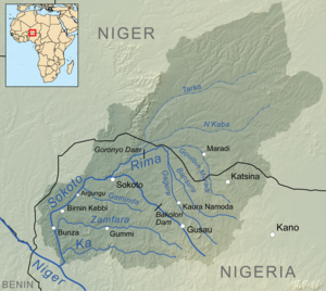
The Sokoto River,, is a river in north-west Nigeria and a tributary of the River Niger. The river's source is near Funtua in the south of Katsina State, some 275 kilometres (171 mi) in a straight line from Sokoto. It flows north-west passing Gusau in Zamfara State, where the Gusau Dam forms a reservoir that supplies the city with water. Further downstream the river enters Sokoto State where it passes by Sokoto and is joined by the Rima River, then turning south and flowing through Birnin Kebbi in Kebbi State. About 120 kilometres (75 mi) south of Birnin Kebbi, it reaches its confluence with the Niger River.

<span class="mw-page-title-main">Hadejia-Nguru wetlands</span>

<span class="mw-page-title-main">Irrigation in Australia</span>

Irrigation is a widespread practice required in many areas of Australia, the driest inhabited continent, to supplement low rainfall with water from other sources to assist in growing crops and pasture. Overuse or poor management of irrigation is held responsible by some for environmental problems such as soil salinity and loss of habitat for native flora and fauna.

<span class="mw-page-title-main">Environmental impact of reservoirs</span>

The environmental impact of reservoirs comes under ever-increasing scrutiny as the global demand for water and energy increases and the number and size of reservoirs increases.

<span class="mw-page-title-main">Environmental effects of irrigation</span> Land & irrigation

The environmental effects of irrigation relate to the changes in quantity and quality of soil and water as a result of irrigation and the subsequent effects on natural and social conditions in river basins and downstream of an irrigation scheme. The effects stem from the altered hydrological conditions caused by the installation and operation of the irrigation scheme.

Despite the crisis in Syria, agriculture remains a key part of the economy. The sector still accounts for an estimated 26 percent of gross domestic product (GDP) and represents a critical safety net for the 6.7 million Syrians – including those internally displaced – who still remain in rural areas. However, agriculture and the livelihoods that depend on it have suffered massive losses . Today, food production is at a record low and around half the population remaining in Syria are unable to meet their daily food needs.

<span class="mw-page-title-main">Kafin Zaki Dam</span> Nigeria Dam

<span class="mw-page-title-main">Tiga Dam</span> Nigeria Water Dam

<span class="mw-page-title-main">Challawa Gorge Dam</span> Dam in northwest Nigeria

The Zobe Dam is in Dutsin-Ma local government area of Katsina State in the north of Nigeria. It is an earth-fill structure with a height of 19 m and a total length of 2,750 m. The dam has a storage capacity of 179 Mca and irrigation potential of 8,000 hectares. Although the dam was completed in 1983, as of 2010, it was still not being used for water supply to Katsina city, for local irrigation or for power generation.

<span class="mw-page-title-main">Kiri Dam</span> Dam in Shelleng, Adamawa State

The Kiri Dam is in Shelleng local government area of Adamawa State in the north east of Nigeria, damming the Gongola River. It is a 1.2 km long, 20 m high zoned embankment with an internal clay blanket. The dam was mainly completed in 1982. The reservoir has a capacity of 615 million m³.

The Ikere Gorge Dam is a major earth-fill dam in Iseyin local government area of Oyo State in the south west of Nigeria on the Ogun River. Reservoir capacity is 690 million m3. The dam was initiated by the military regime of General Olusegun Obasanjo and started in 1983 by the administration of Shehu Shagari. The dam was planned to generate 37.5 MW of electricity, to supply water to local communities and to Lagos and to irrigate 12,000 hectares of land. Built in 1982/1983, work on the dam was abandoned by subsequent military governments. A report for the UN in 2004 said that no irrigation had taken place so far, but efforts were being made to implement one of the five planned irrigation projects. The project was based on the sprinkler system which is difficult to manage and requires that the farmers be trained.

<span class="mw-page-title-main">Zauro polder project</span>

The Zauro polder project is an irrigation scheme that has long been planned for the Rima River floodplain in Kebbi State, Nigeria. The project is controversial, and would demand careful management to achieve the planned benefits.

<span class="mw-page-title-main">Bhadra Dam</span> Dam in Karnataka, India

The Bhadra Dam or Lakkavalli Dam, which has created the Bhadra Reservoir, is located on the Bhadra River a tributary of Tungabhadra River. Bhadra Dam is located in the border of Bhadravathi and Tarikere, in the western part of Karnataka in India. The benefits derived from the reservoir storage are irrigation with gross irrigation potential of 162,818 hectares, hydro power generation of 39.2 MW, drinking water supply and industrial use. The dam commissioned in 1965 is a composite earth cum masonry structure of 59.13 metres (194.0 ft) height with length of 1,708 metres (5,604 ft) at the crest level, which submerges a land area of 11,250.88 hectares.

Kano River Project is a modern integrated agricultural land use development in Northern Nigeria. River Kano also locally called Kogin Kano. The project is a large scale irrigation project developed under the authority of Hadejia-Juma’are River Basin Development Authority.

Kedung Ombo Reservoir is one of the major reservoirs in Indonesia. It is located on the border of three regencies in Central Java Province, namely Grobogan Regency, Sragen Regency, and Boyolali Regency, in District Geyer, Grobogan District. The main dam of Kedung Ombo Reservoir is located on the border of Rambat Village and Juworo Village, Geyer Sub-District, Grobogan District. This reservoir uses Serang River as its main source of water, along with the Uter/Sungai Kombo/Banjaran River. Other water sources are supplied from several large and small rivers that supply water to Kedung Ombo Reservoir, including the Braholo River, Central River, Nglanji River, Tapen River and Sambas River.

References

  1. 1 2 3 4 5 6 7 Akané Hartenbach & Jürgen Schuol (October 2005). "Bakolori Dam and Bakolori Irrigation Project – Sokoto River, Nigeria" (PDF). Eawag aquatic research institute. Retrieved 2010-01-10.[ permanent dead link ]
  2. 1 2 3 4 5 MOHAMMED KUTA YAHAYA (2002). "DEVELOPMENT AND CHALLENGES OF BAKOLORI IRRIGATION PROJECT IN SOKOTO STATE, NIGERIA" (PDF). Nordic Journal of African Studies. 11 (3): 411–430. Archived from the original (PDF) on 2021-09-09. Retrieved 2010-01-10.
  3. 1 2 Displacement and the politics of violence in Nigeria. BRILL. 1997. p. 76. ISBN   90-04-10876-9.
  4. David Anderson; Richard H. Grove (1990). Conservation in Africa: Peoples, Policies and Practice. Cambridge University Press. p. 312. ISBN   0-521-34990-7.
  5. 1 2 Adams, W.M. (September 1993). "Development's deaf ear: Downstream users and water releases from the Bakolori Dam, Nigeria". World Development. 21 (9): 1405–1416. doi:10.1016/0305-750X(93)90121-O.
  6. Scudder, Thayer (2005). The future of large dams: dealing with social, environmental, institutional and political costs . Earthscan. p.  236. ISBN   1-84407-155-3.
  7. 1 2 Adams, William (January 2000). "Downstream Impacts of Dams" (PDF). Thematic Review I.1. World Commission on Dams. Archived from the original (PDF) on 2012-02-25. Retrieved 2010-01-22.
  8. Adams, William Mark (2001). Green development: environment and sustainability in the Third World . Routledge. p.  231. ISBN   0-415-14766-2.
  9. de Schutter, Joop (2003). "Water Resources and Environment Technical Note G.3 Wetlands Management" (PDF). Washington, D.C. US: World Bank. p. 15. Retrieved 2015-09-12.
  10. "Fishery Resources of Nigerian Inland Waters". Food and Agriculture Organization. Retrieved 2010-01-11.
  11. "Fishery Resources of Nigerian Inland Waters - The Niger/Sokoto River Basin". Food and Agriculture Organization. Retrieved 2010-01-22.
  12. M.O.E. Orode (1984-11-09). Tropical grain legume bulletin, Issue 28. International Grain Legume Information Centre. p. 88.
  13. M. Kebbeh, S. Haefele and S. O. Fagade1 (September 2003). "Challenges and Opportunities for Improving Irrigated Rice Productivity in Nigeria" (PDF). West Africa Rice Development Association. Archived from the original (PDF) on 2008-11-16. Retrieved 2010-01-11.
  14. "Background on issues relating to Water". United Nations. Archived from the original on 2011-06-04. Retrieved 2010-01-11.
  15. G. E. Hollis; M. M. Holland; E. Maltby & J. S. Larson (January–March 1988). Wise Use of Wetlands (PDF). Nature and Resources. Vol. XXIV. UNESCO.