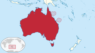
The Coral Sea Islands Territory is an external territory of Australia which comprises a group of small and mostly uninhabited tropical islands and reefs in the Coral Sea, northeast of Queensland, Australia. The only inhabited island is Willis Island. The territory covers 780,000 km2 (301,160 sq mi), most of which is ocean, extending east and south from the outer edge of the Great Barrier Reef and includes Heralds Beacon Island, Osprey Reef, the Willis Group and fifteen other reef/island groups. Cato Island is the highest point in the Territory.

Iloilo, officially the Province of Iloilo, is a province in the Philippines located in the Western Visayas region. Its capital is the City of Iloilo. Iloilo occupies a major southeast portion of the Visayan island of Panay and is bordered by the province of Antique to the west, Capiz to the north, the Jintotolo Channel to the northeast, the Guimaras Strait to the east, and the Iloilo Strait and Panay Gulf to the southwest.

Carles, officially the Municipality of Carles, is a 2nd class municipality in the province of Iloilo, Philippines. According to the 2020 census, it has a population of 72,637 people.
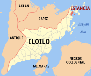
Estancia, officially the Municipality of Estancia, is a 2nd class municipality in the province of Iloilo, Philippines. According to the 2020 census, it has a population of 53,200 people.

Northeast Cay, also known as Parola Island, with a land area of 12.7 hectares, is the fifth largest of the naturally occurring Spratly Islands and the third largest of the Philippine-occupied islands. It is part of the North Danger Reef and is located to the northwest of Dangerous Ground.

The Quiniluban Group is a group of islands in Palawan Province of the Philippines situated between the islands of Palawan and Panay in the Sulu Sea. The group is the northernmost in the Cuyo Archipelago, consisting of several islands and rocks. The easternmost of which is a circular group of islands surrounded by reef about 6 nautical miles in diameter. The largest of the circular group is Quiniluban Island. The island group also includes the upscale resort island of Pamican located about 5.6 nautical miles southwest of the circular group, and Manamoc Island located 3.0 nautical miles further southwest of Pamilacan.

Sicogón is an island in northern Iloilo, which is part of the municipality of Carles, Iloilo, Philippines. It is named after cogon, a type of grass found in abundance on the island. According to the 2010 census, it has a population of 5,238.

Islas de Gigantes is an island chain within the larger Western Visayas archipelago in the Visayan Sea. It is part of the municipality of Carles, Iloilo, Philippines, and the northernmost part of Iloilo province. The Gigantes islands consist of about ten islands; the two largest are Gigantes Norte and Gigantes Sur. According to the 2010 census, it has a population of 12,224. There is also a lighthouse on Gigantes Norte.

Loguingot is a small island-barangay in northeastern Iloilo, Philippines. It is part of the municipality of Estancia. According to the 2010 census, it has a population of 796. Fishing is the main source of income for the island's residents.

Pangalan Islet is a low, uninhabited islet in northeastern Iloilo, Philippines. It is part of the municipality of Estancia under the jurisdiction of the barangay of Manipulon.
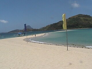
Bulubadiangan Island is a privately owned island in northeastern Iloilo, Philippines. It is part of barangay Polopińa, Concepcion. The Sandbar Island Beach Resort on Bulubadiangan is moderately known within the Philippines.
Manigonigo Island is an island in northeastern Iloilo, Philippines. It is one of fourteen islands politically administered by the municipality of Carles. The island's lighthouse was built by the Spanish during Spanish rule.
Bocot Island is a small island in northeastern Iloilo, Philippines. It is part of the municipality of Concepcion.
Manlot is an uninhabited island-barangay in northeastern Iloilo, Philippines. It is one of fourteen islands politically administered by the municipality of Carles.
Himamylan is an uninhabited island in northeastern Iloilo, Philippines. It is one of fourteen islands politically administered by the municipality of Carles.
Binuluangan is an inhabited island-barangay in northeastern Iloilo, Philippines. It is one of fourteen islands politically administered by the municipality of Carles. In 2010 it had a population of 1,682. There is an elementary school on the island.
Cabugao is a small, uninhabited island in northeastern Iloilo, Philippines. It is one of fourteen islands politically administered by the municipality of Carles. Along with Bantigui Island and Antonia Island, it is one of three minor southern islets in the Islas de Gigantes archipelago.
Tanguingui is a small, uninhabited island in the Visayan Sea of the Philippines. The island is under the jurisdiction of the municipality of Madridejos, Cebu. There is a lighthouse on the island.

Pujada Bay, sometimes called Pujaga Bay, is a bay on the Pacific coast of the southern Philippine island of Mindanao. It is an arm of the Philippine Sea in Davao Oriental province formed by the Guanguan Peninsula which separates it from the Mayo Bay on the east and the Pujada Peninsula which separates it from the Davao Gulf on the west. Pujada Bay borders Mati, the province's capital and largest city, with its port and city proper situated at its head. It is entered between Lamigan Point on the east and Tumago Point on the west, with the Pujada Island dividing its entrance into two channels. There are three other islands on the bay, namely Uanivan, Oak and Ivy islands.
Malabungot, alternatively spelled as Malabungut, and also known as Mahad, is an island in Binagasbasan Bay off the coast of Garchitorena in Camarines Sur, Philippines. It is separated from Caramoan Peninsula in the south by the Quinalasag Passage, also known as Sisiran Passage, which connects Lamit and Sisiran bays. The island forms the head of Binagasbasan Bay, bordered to the west by the Lamit Islands and to the east by Quinalasag Island, and which opens northward to the Philippine Sea. It is designated as a protected landscape and seascape on account of its biodiversity and ecological significance.
