
Mission Dolores Park, often abbreviated to Dolores Park, is a city park in San Francisco, California. It is located two blocks south of Mission Dolores at the western edge of the Mission District.

Muni Metro is a light rail system serving San Francisco, California, United States. Operated by the San Francisco Municipal Railway (Muni), a part of the San Francisco Municipal Transportation Agency (SFMTA), Muni Metro served an average of 157,700 passengers per weekday in the fourth quarter of 2019, making it the second-busiest light rail system in the United States.

The M Ocean View is a hybrid light rail/streetcar line of the Muni Metro system in San Francisco, California. The line opened on October 6, 1925.

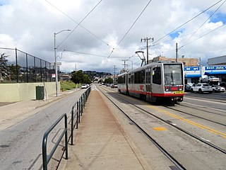
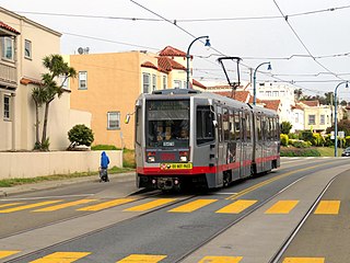
The K Ingleside is a hybrid light rail/streetcar line of the Muni Metro system in San Francisco, California. It mainly serves the West Portal and Ingleside neighborhoods. The line opened on February 3, 1918, and was the first line to use the Twin Peaks Tunnel.

John McLaren Park is a park in southeastern San Francisco. At 312.54 acres (126.48 ha), McLaren Park is the third largest park in San Francisco by area, after Golden Gate Park and the Presidio. The park is surrounded mostly by the Excelsior, Crocker-Amazon, Visitacion Valley, Portola and University Mound neighborhoods.
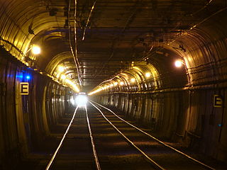
The Twin Peaks Tunnel is a 2.27-mile-long (3.65 km) light rail/streetcar tunnel in San Francisco, California. The tunnel runs under Twin Peaks and is used by the K Ingleside, M Ocean View and S Shuttle lines of the Muni Metro system.

Balboa Park station is a Bay Area Rapid Transit (BART) station and Muni Metro complex in the Mission Terrace neighborhood of San Francisco, California, located near the eponymous Balboa Park. It is an intermodal hub served by four BART routes, three Muni Metro lines, and a number of Muni bus routes. The station complex also includes two rail yards, Cameron Beach Yard and Green Light Rail Center, where Muni maintains Muni Metro trains and heritage streetcars. BART uses a below-grade island platform on the west side of the complex; Muni Metro routes use several smaller side platforms located on surface-level rail loops around the yards.

The T Third Street is a Muni Metro light rail line in San Francisco, California. It runs along the east side of San Francisco from Sunnydale to Chinatown, traveling in the median of Third Street for most of its length before entering the Central Subway as it approaches downtown. The line serves 22 stations, all of which are accessible. Most of the surface portion of the line runs in dedicated median lanes, though two portions operate in mixed traffic.

Outer Mission is a small residential neighborhood on the south edge of San Francisco, bounded by Geneva Avenue, Interstate 280, Mission Street, and the city of Daly City. It is bordered by the Mission Terrace, Crocker-Amazon, and Ingleside, and touches Excelsior. The Muni streetcar historic "car barn" is at the northern corner of this neighborhood. Cayuga Park is located in this neighborhood. The Cayuga Improvement Association (CIA) covers the area bounded by Interstate 280, Mission Street, Sickles and Onondaga. Some folks have attempted to define "Cayuga Terrace" as a subset neighborhood of the larger Mission Terrace neighborhood, but maps show Geneva Avenue as the cutoff.
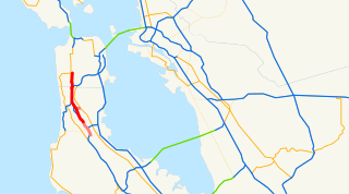
Junipero Serra Boulevard is a major boulevard in and south of San Francisco named after Franciscan friar Junipero Serra. Within the city, it forms part of the route of State Route 1, the shortest connection between Interstate 280 and the Golden Gate Bridge. The remainder, in San Mateo County, was bypassed or replaced by I-280, the Junipero Serra Freeway. The boulevard was one of several new roads built along the San Francisco Peninsula before the age of freeways, and became a state highway known as Route 237 in 1956, receiving the State Route 117 designation in the 1964 renumbering, only to be deleted from the state highway system the next year. Two other regional highways—Bayshore Highway and Skyline Boulevard—were also upgraded into or bypassed by freeways.
Oceanview is a neighborhood in the southern portion of San Francisco, California. It was first established as a community in the 1910s and originally centered on the intersection of Sagamore Street and San Jose Avenue. Today, the neighborhood is bordered by Orizaba Avenue to the west, Lakeview Avenue to the north, and Interstate 280 to the south and east.
San Jose and Ocean station is a light rail stop on the Muni Metro J Church line, located in the Mission Terrace neighborhood of San Francisco, California adjacent to the Balboa Park neighborhood and the Balboa Park station complex. The station has two side platforms in the middle of San Jose Avenue located before the intersection in each direction where passengers board or depart from trains. The station is not accessible to people with disabilities.
Ocean and San Leandro is a light rail stop on the Muni Metro K Ingleside line, located between the Balboa Terrace and Ingleside Terrace neighborhoods of San Francisco, California. It originally opened around 1896 on the United Railroads (12) line; K Ingleside service began in 1919. The stop consists of two side platforms, with the eastbound (outbound) platform located on Ocean Avenue west of the intersection with San Leandro Way, and vice versa.

Ocean and Aptos is a light rail stop on the Muni Metro K Ingleside line, located between the Balboa Terrace and Ingleside Terrace neighborhoods of San Francisco, California. The stop consists of two side platforms, with the eastbound (outbound) platform located on Ocean Avenue west of the intersection with Aptos Avenue, and vice versa. It originally opened around 1896 on the United Railroads 12 line; K Ingleside service began in 1919.

Ocean and Lee is a light rail stop on the Muni Metro K Ingleside line, located between the Westwood Park and Ingleside neighborhoods of San Francisco, California. The stop consists of two side platforms, with the eastbound (outbound) platform located on Ocean Avenue west of the intersection with Lee Street, and vice versa.

Ocean Avenue/CCSF Pedestrian Bridge station is a light rail stop on the Muni Metro K Ingleside line, located between the Sunnyside and Ingleside neighborhoods of San Francisco, California adjacent to the City College of San Francisco (CCSF) campus. The stop consists of two side platforms in the median of Ocean Avenue, with stairs to a concrete footbridge that connects the campus to Geneva Avenue. It opened in 1979 with the extension of the line to Balboa Park station; it was previously served by the United Railroads 12 line from 1895 to 1945, and the K from 1945 to 1952.

San Jose and Mount Vernon station is a light rail stop on the Muni Metro M Ocean View line, located in the Ingleside neighborhood of San Francisco, California. The inbound platform is located on a bridge over Interstate 280. The station opened with the extension of the line to Balboa Park station on August 30, 1980. The station has two side platforms in the middle of San Jose Avenue where passengers board or depart from trains. The stop is not accessible to people with disabilities.
Ingleside Terraces is an affluent residential neighborhood of approximately 750 detached homes built at the former location of the Ingleside Racetrack in the southwestern part of San Francisco. It is adjacent to the Balboa Terrace, Ingleside, Merced Heights and Lakeside neighborhoods, and is bordered by Ocean Avenue to the north, Ashton Avenue to the east, Holloway Avenue to the south and Junipero Serra Boulevard to the west. The main local event that occurs is the Annual Sundial Park Picnic, in which the local residents host bicycle, chariot, and wagon racing. There is a large sundial located on Entrada Court, surrounded by the oval-shaped Urbano Drive, which was once a horse race track. Ingleside Terraces is one of nine master-planned residence parks in San Francisco.

Lincoln Manor is one of the master-planned residence parks in the western neighborhoods of San Francisco, with the others including Sea Cliff, St. Francis Wood, Presidio Terrace, West Clay Park, Forest Hill, Balboa Terrace, Ingleside Terraces, and Jordan Park. Lincoln Manor, established in 1914, is located within the Richmond District, in the Northwest portion of San Francisco. Lincoln Manor is bounded by 36th Avenue to the East, 38th Avenue to the West, Clement Street to the North, Geary Boulevard to the South, and is bisected by Shore View Avenue. The tract features a slight rise in elevation, which provides houses in Lincoln Manor with a view south toward the Pacific Ocean. Its single-family generally large detached homes were developed between approximately 1914-1916 by Lyon & Hoag as a so-called "restricted residence park," built by the S.A. Born Building Company, builders of West Clay Park and Sea Cliff. Lincoln Manor was promoted by its developers as a residence park with ocean views facing south instead of west. The enclave abuts Land's End, Lincoln Park, and the Legion of Honor, and is close to Sea Cliff, the Balboa Street shopping district, and the Katherine Delmar Burke School.


