
Swords, the county town of Fingal, is a large suburban town on the east coast of Ireland, situated ten kilometres north of Dublin city centre. The town was reputedly founded c. AD 560. Located on the Ward River, Swords features Swords Castle, a restored medieval castle, a holy well from which it takes its name, a round tower and a Norman tower. Facilities in the area include the Pavilions shopping centre, one of the largest in the Dublin region, a range of civic offices, some light industries, the main storage facility and archive of the National Museum of Ireland and several parks. Dublin Airport is located nearby.

Fingal is a county in Ireland. It is in the province of Leinster and is part of the Eastern and Midland Region. It is one of three successor counties to County Dublin, which was disestablished for administrative purposes in 1994. Its name is derived from the medieval territory of Scandinavian foreigners that settled in the area. Fingal County Council is the local authority for the county. In 2022 the population of the county was 329,000, making it the second most populated council in Dublin and the third most populous county in the state.

Sutton is a residential suburb on the Northside of Dublin, Ireland. It occupies the tombolo which links Howth Head to the mainland, some of the lower slopes of Howth Hill, and a little of the adjacent coasts. The area lies within the jurisdiction of Fingal County Council. There is a small commercial core at the Sutton Cross road intersection.

Howth is an affluent peninsular village and outer suburb of Dublin, Ireland. The district as a whole occupies the greater part of the peninsula of Howth Head, which forms the northern boundary of Dublin Bay, and includes the island of Ireland's Eye, which holds multiple natural protection designations.

Skerries is a coastal town in Fingal, in the north of County Dublin, Ireland. Skerries was historically a fishing port and later a centre of hand embroidery. These industries declined in the early 20th century, however, and it became both a resort town and a commuter town for Dublin City, located approximately 30 km (19 mi) to the south. Offshore from the town are several islands, one of which is a nature reserve, Rockabill.

Rush, officially An Ros, is a small seaside commuter town in Fingal, Ireland. It was one of the few towns of the historic County Dublin. Rush lies on the Irish Sea coast, between Skerries and Lusk, and has a small harbour. It had a population at the 2011 census of 9,231.
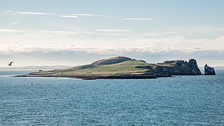
Ireland's Eye is a small long-uninhabited island off the coast of County Dublin, Ireland. Situated directly north of Howth village and harbour, the island is easily reached by regular seasonal tourist boats, which both circumnavigate it and drop off day trippers. There is a yacht anchorage to the north of it, and kayakers also land.

Howth Castle and estate lie just outside the village of Howth, County Dublin in Ireland, in the administration of Fingal County Council. The castle was the ancestral home of the line of the St Lawrence family that had held the area since the Norman Invasion of 1180, and held the title of Lord of Howth until circa 1425, the Baron Howth to 1767, then Earl of Howth until 1909. The castle and estate are held since 1909 by their distaff heirs, the Gaisford-St Lawrence family.

Naul, is a village, townland, and civil parish at the northern edge of Fingal and the traditional County Dublin in Ireland. The Delvin River to the north of the village marks the county boundary with County Meath. Naul civil parish is in the historic barony of Balrothery West.

Lusk is a small town in Fingal, Ireland. The town is located about 20 km (12 mi) north of Dublin city centre.

Balrothery Tower is a tower house and a National Monument in Balrothery, Ireland.
Castleknock is a civil parish and a townland located in the south-western corner of the modern county of Fingal, Ireland. The civil parish is part of the ancient barony of Castleknock. It is centred on the suburban village of Castleknock. The townland of Castleknock itself is the location of the eponymous "Cnucha's Castle" – Castleknock Castle. The town with the biggest population in the parish is Blanchardstown. In geology, the parish rests on a substratum of limestone and comprises 2943 statute acres, the whole of which is arable land.

Sutton Castle or Sutton House is a Victorian Tudor-style castellated mansion house with terraced gardens on the southern coast of Howth Head, overlooking Dublin Bay, in the suburbs of Dublin, Ireland.
29 Martello towers and battery installations were constructed or partially constructed in the Greater Dublin Area between 1803 and 1808. The towers were intended to act as a deterrent against a foreign invasion by Napoleon and his French Armies as well as being used as general lookout posts. In later years, towers were also used as coast guard stations, lookout stations to prevent smuggling and as other general purpose military installations by various British and Irish defence forces.

Corr Castle is an L-plan tower house likely constructed sometime in the fifteenth century in Sutton, Dublin. The castle lies within the boundaries of Howth Demesne in the old townland of Correston, close to the townlands of Quarry and Burrow. The castle was probably built on higher ground in order to guard the isthmus at Sutton which was the only route on land to access Howth Castle and the port of Howth. It has historically sometimes been called The Dane's castle.
Clonsilla or "Clonsillagh" is a civil parish and a townland located in the south-western corner of the modern county of Fingal, Ireland. The civil parish is part of the ancient barony of Castleknock. It is centred on the suburban village of Clonsilla. In geology, the parish rests on a substratum of limestone and comprises 2943 statute acres, the whole of which is arable land. It is roughly bounded to the north by the old "Navan Road" – the modern N3; to the east by the civil parish of Castleknock; to the south by the River Liffey; to the south-east by the civil parish of Leixlip, chiefly in County Kildare, and to the north-west by the civil parish of Dunboyne in County Meath.


