The Pike's Peak Gold Rush was the boom in gold prospecting and mining in the Pike's Peak Country of western Kansas Territory and southwestern Nebraska Territory of the United States that began in July 1858 and lasted until roughly the creation of the Colorado Territory on February 28, 1861. An estimated 100,000 gold seekers took part in one of the greatest gold rushes in North American history.
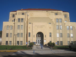
Colfax County is a county in the U.S. state of New Mexico. As of the 2020 census, the population was 12,387. Its county seat is Raton. It is south from the Colorado state line. This county was named for Schuyler Colfax (1823–1885), seventeenth Vice President of the United States under U.S. President Ulysses S. Grant.

Ely is the largest city and county seat of White Pine County, Nevada, United States. Ely was founded as a stagecoach station along the Pony Express and Central Overland Route. In 1906 copper was discovered. Ely's mining boom came later than the other towns along US 50. The railroads connecting the transcontinental railroad to the mines in Austin, Nevada and Eureka, Nevada have long been removed, but the railroad to Ely is preserved as a heritage railway by the Nevada Northern Railway and known as the Ghost Train of Old Ely. As of the 2020 census, the population was 3,924.

Philmont Scout Ranch is a ranch located in Colfax County, New Mexico, near the village of Cimarron; it covers 140,177 acres (56,728 ha) of wilderness in the Sangre de Cristo Mountains on the east side of the Cimarron Range of the Rocky Mountains. Donated by oil baron Waite Phillips, the ranch is owned and operated by the Boy Scouts of America. It is a National High Adventure Base where crews of Scouts and Venturers take part in backpacking treks and other outdoor activities. By land area, it is one of the largest youth camps in the world. During the 2019 season, between June 8 and August 22, an estimated 24,000 Scouts and adult leaders backpacked through the Ranch's extensive backcountry. That same year 1,302 staff were responsible for the Ranch's summer operations.

Hillsboro is an unincorporated community in Sierra County, New Mexico, United States, located in the southwestern part of the state. It was founded in 1877, following the discovery of gold. The community was the county seat of Sierra County from 1884 until 1936, when Hot Springs became the county seat.

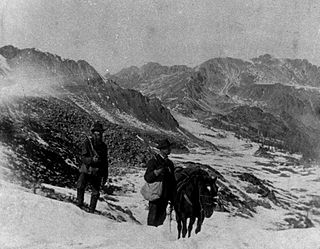
Baldy Mountain, Baldy Peak, Mount Baldy, or Old Baldy is the highest peak in the Cimarron Range, a subrange of the Sangre de Cristo Mountains of New Mexico. It is located in Colfax County, about 6 miles (10 km) northeast of Eagle Nest. It rises abruptly, with 3,640 feet (1,110 m) of vertical relief, from the Moreno Valley to the west and has a total elevation of 12,441 feet (3,792 m).

Mining in Australia has long been a significant primary sector industry and contributor to the Australian economy by providing export income, royalty payments and employment. Historically, mining booms have also encouraged population growth via immigration to Australia, particularly the gold rushes of the 1850s. Many different ores, gems and minerals have been mined in the past and a wide variety are still mined throughout the country.
Greenwater was an unincorporated community near Death Valley located in the eastern side of the Inyo County, California. It is now a deserted ghost town.
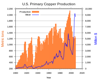
In the United States, copper mining has been a major industry since the rise of the northern Michigan copper district in the 1840s. In 2017, the US produced 1.27 million metric tonnes of copper, worth $8 billion, making it the world's fourth largest copper producer, after Chile, China, and Peru. Copper was produced from 23 mines in the US. Top copper producing states in 2014 were Arizona, Utah, New Mexico, Nevada, and Montana. Minor production also came from Idaho, and Missouri. As of 2014, the US had 45 million tonnes of known remaining reserves of copper, the fifth largest known copper reserves in the world, after Chile, Australia, Peru, and Mexico.

The Cerro Gordo Mines are a collection of abandoned mines located in Cerro Gordo in the Inyo Mountains, Inyo County, near Lone Pine, California. Mining operations spanned 1866 to 1957, producing high grade silver, lead, zinc ore, and more rarely gold ore and copper ore. Some ore was smelted on site, but larger capacity smelters were eventually constructed along the shore of nearby Owens Lake.
Silver mining in Arizona was a powerful stimulus for exploration and prospecting in early Arizona. Cumulative silver production through 1981 totaled 490 million troy ounces. However, only about 10% of Arizona's silver production came from silver mining. More than 80% of the state's silver was a byproduct of copper mining; other silver came as a byproduct of lead, zinc, and gold mining.
Elizabethtown is an unincorporated community in Colfax County, New Mexico, United States. It is located just off New Mexico State Road 38, between the communities of Eagle Nest and Red River. Elizabethtown is just east of the Carson National Forest. The community is a former mining town, and lies northeast of Scully Mountain, and west of Baldy Mountain.

Gold Hill is an unincorporated community in far western Tooele County, Utah, located near the Nevada state line.
Gold mining in Alaska, a state of the United States, has been a major industry and impetus for exploration and settlement since a few years after the United States acquired the territory in 1867 from the Russian Empire. Russian explorers discovered placer gold in the Kenai River in 1848, but no gold was produced. Gold mining started in 1870 from placers southeast of Juneau, Alaska.

The Maxwell Land Grant, also known as the Beaubien-Miranda Land Grant, was a 1,714,765-acre (6,939.41 km2) Mexican land grant in Colfax County, New Mexico, and part of adjoining Las Animas County, Colorado. This 1841 land grant was one of the largest contiguous private landholdings in the history of the United States. The New Mexico communities of Cimarron, Dawson, Elizabethtown, Baldy Town, Maxwell, Miami, Raton, Rayado, Springer, Ute Park and Vermejo Park came to be located within the grant, as well as numerous places that are now ghost towns.

Confederate Gulch is a steeply incised gulch or valley on the west-facing slopes of the Big Belt Mountains in the U.S. state of Montana. Its small stream drains westward into Canyon Ferry Lake, on the upper Missouri River near present-day Townsend, Montana. In 1864, Confederate soldiers on parole during the American Civil War made a minor gold discovery in the gulch, but the discovery of the sensationally rich Montana Bar the following year—one of the richest placer strikes per acre ever made—led to other rich gold strikes up and down the gulch, and touched off a frantic boom period of placer gold mining in the area that extended through 1869. From 1866 to 1869, the gulch equaled or outstripped all other mining camps in the Montana Territory in gold production, producing an estimated $19–30 million worth of gold. For a time, Confederate Gulch was the largest community in Montana. In 1866, Montana had a total population of 28,000, and of these, about 10,000 (35%) were working in Confederate Gulch.
Philmont Scout Ranch is located in the Sangre de Cristo Mountains of the Rocky Mountains of New Mexico. Philmont is about 12 miles (19 km) across at its widest point, and about 30 miles (48 km) long. The southern part of the ranch is mostly grasslands/prairie, while the north is rocky and rugged, but a small part of the eastern area is prairie.
The French Henry mine is a gold and silver mine located on Baldy Mountain. The mine was in operation intermittently from 1870 to 1938. Part of the Baldy Mining District, the mine has changed ownership many times and is now owned by the Boy Scouts of America as a part of Philmont Scout Ranch. The French Henry is no longer operational.

Baldy Town, New Mexico is a former mining town in the Baldy Mining District in Colfax County, New Mexico. Baldy Town was established in 1868, to service mining prospects on the East side of Baldy Mountain, notably the Aztec Mine. After Baldy Town's initial high profit boom from 1868-1870, Baldy Town suffered a series of booms and busts as investors and prospectors searched for profitable lodes. The town was originally a conglomerate of miner's homes and services in Ute Meadow. Then in 1886, Baldy Town's core was moved to a strip of services just above the Aztec Mill. The new town grew to accommodate hundreds of residents with a store, stables, saloons, boarding houses, a church, small school, and post office. In 1895, at the height of its population, Baldy Town was home to around 1,000 residents. Multiple ambitious and extensive expeditions were made from 1870-1936 to discover additional gold veins, but only a select few found substantial lodes. By 1941, Baldy Town had been deserted and a majority of its infrastructure sold. In 1963, the eastern half of Baldy Mountain, including former Baldy Town, was donated to the Boy Scouts of America by Norton Clapp. Today, Baldy Town operates as a staffed camp at Philmont Scout Ranch providing a living history program regarding mining as well as logistical support like food resupply for hikers

