Natural Resources Conservation Service (NRCS), formerly known as the Soil Conservation Service (SCS), is an agency of the United States Department of Agriculture (USDA) that provides technical assistance to farmers and other private landowners and managers.
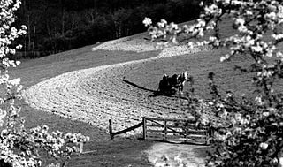
Contour bunding or contour farming or contour ploughing is the farming practice of plowing and/or planting across a slope following its elevation contour lines. These contour lines create a water break which reduces the formation of rills and gullies during times of heavy precipitation, allowing more time for the water to settle into the soil. In contour plowing, the ruts made by the plow run perpendicular rather than parallel to the slopes, generally furrows that curve around the land and are level. This method is also known for preventing tillage erosion. Tillage erosion is the soil movement and erosion by tilling a given plot of land. A similar practice is contour bunding where stones are placed around the contours of slopes. Contour ploughing has been proved to reduce fertilizer loss, power and time consumption, and wear on machines, as well as to increase crop yields and reduces soil erosion.

Strip cropping is a method of farming which involves cultivating a field partitioned into long, narrow strips which are alternated in a crop rotation system. It is used when a slope is too steep or when there is no alternative method of preventing soil erosion. The most common crop choices for strip cropping are closely sown crops such as hay, wheat, or other forages which are alternated with strips of row crops, such as corn, soybeans, cotton, or sugar beets. The forages serve primarily as cover crops. In certain systems, strips in particularly-eroded areas are used to grow permanent protective vegetation, but in most systems, all strips are alternated on an annual basis.
Kalkaska sand is the official soil of the U.S. state of Michigan.

Erosion control is the practice of preventing or controlling wind or water erosion in agriculture, land development, coastal areas, river banks and construction. Effective erosion controls handle surface runoff and are important techniques in preventing water pollution, soil loss, wildlife habitat loss and human property loss.
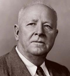
Hugh Hammond Bennett was a pioneer in the field of soil conservation in the United States of America. He was the head of the Soil Conservation Service, a federal agency now referred to as the Natural Resources Conservation Service.

The National Cooperative Soil Survey Program (NCSS) in the United States is a nationwide partnership of federal, regional, state, and local agencies and institutions. This partnership works together to cooperatively investigate, inventory, document, classify, and interpret soils and to disseminate, publish, and promote the use of information about the soils of the United States and its trust territories. The activities of the NCSS are carried out on national, regional, and state levels.

The Miami, Indiana soil series is the state soil of Indiana.

Prime farmland is a designation assigned by U.S. Department of Agriculture defining land that has the best combination of physical and chemical characteristics for producing food, feed, forage, fiber, and oilseed crops and is also available for these land uses.
Downer is the New Jersey state soil. The Downer has four soil horizons:
Orovada series soil is the official state soil of Nevada. The soil series has an extent of 367,853 acres (148,865 ha), primarily in northern and central Nevada, and extending into southern Idaho and Oregon. They are common soils on semiarid rangeland with sagebrush-grassland plant communities. Orovada soils are arable, able to be cultivated, when irrigated and are considered prime farmland. Alfalfa for hay and seed, winter wheat, barley, and grasses for hay and pasture are the principal crops grown on these soils.

Sonoma Coast State Park is a State of California property in Sonoma County consisting of public access use on lands adjoining the Pacific Ocean. This extent of beach runs from a coastal point about 4 miles (6 km) north of Jenner and continues for approximately 17 miles (27 km) to the south to terminate at Bodega Head. The property lies along State Route 1 and consists of a number of named beaches including Arched Rock Beach, Gleason Beach and Goat Rock Beach. The ecosystem consists of alternating sandy beaches and rocky shoreline, with a marine terrace extending above the entire extent with an upland California coastal prairie habitat.

San Joaquin is an officially designated state insignia, the state soil of the U.S. state of California.

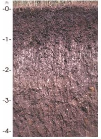
Antigo soils are among the most extensive soils in Wisconsin. They occur on about 300,000 acres (1,200 km²) in the northern part of the State. Antigo soils are well-drained and formed under northern hardwood forests in loess and loamy sediments over stratified sandy outwash. The average annual precipitation ranges from 28 to 33 inches, and the average annual air temperature ranges from 39 to 45 °F. The soil series was named after the city of Antigo, Wisconsin.
Myakka soil is the official state soil of Florida, which has more than 1,500,000 acres (6,100 km2) of land composed partly or entirely of Myakka soils, out of its total acreage of 42,084,928 acres (170,311.66 km2). This soil is primarily located in broad flatwoods in irregularly shaped areas ranging from 5 to 500 acres in size. The organic matter content and fertility of the soil is low. Most areas where this soil occurs are native range or improved pasture, although some is used for citrus or vegetable farming. Some counties in Florida where this soil occurs are Hendry, Collier, Glades, and Lee.
Houdek is a type of soil composed of glacial till and decomposed organic matter. The soil series was established in 1955 in Spink County, South Dakota. It is unique to the United States, but in particular to South Dakota where it is the state soil.

A buffer strip is an area of land maintained in permanent vegetation that helps to control air quality, soil quality, and water quality, along with other environmental problems, dealing primarily on land that is used in agriculture. Buffer strips trap sediment, and enhance filtration of nutrients and pesticides by slowing down surface runoff that could enter the local surface waters. The root systems of the planted vegetation in these buffers hold soil particles together which alleviate the soil of wind erosion and stabilize stream banks providing protection against substantial erosion and landslides. Farmers can also use buffer strips to square up existing crop fields to provide safety for equipment while also farming more efficiently.
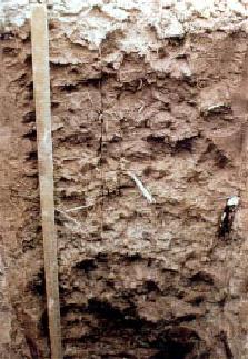
Menfro soil is a series of deep, well drained, moderately permeable soils formed in 6-to-20-foot thick loess deposits. It is found in central and eastern Missouri and west-central and southwestern Illinois on upland ridgetops, backslopes, and benches adjacent to the Missouri and Mississippi rivers and their major tributaries. Menfro soils are prime farmland where the slope is less than 6 percent.
Calcids are a soil suborder in the USDA soil taxonomy. They are aridisols that have accumulated high levels of residual or dryfall calcium carbonate.
