
Edgar County is a county located in the U.S. state of Illinois. As of the 2010 United States Census, the population was 18,576. Its county seat is Paris.

Bingham County is a county in the U.S. state of Idaho. As of the 2010 United States Census, the population was 45,607. The county seat and largest city is Blackfoot.

Cordillera Administrative Region (CAR), also known as Cordillera Region, is an administrative region in the Philippines, situated within the island of Luzon. The only landlocked region in the insular country, it is bordered by the Ilocos Region to west and southwest, and by the Cagayan Valley Region to the north, east, and southeast. It is the least populous region in the Philippines, with a population less than that of the City of Manila.

Google Maps is a web mapping service developed by Google. It offers satellite imagery, aerial photography, street maps, 360° interactive panoramic views of streets, real-time traffic conditions, and route planning for traveling by foot, car, bicycle and air, or public transportation. In 2020, Google Maps was used by over 1 billion people every month.
State Highway 251A, also known as SH-251A or OK-251A, is a highway maintained by the U.S. state of Oklahoma. The highway has a length of 5.37 miles (8.64 km) in Wagoner County and 0.69 miles (1.11 km) in Cherokee County, for a total length of 6.06 miles (9.75 km). The highway runs from State Highway 16 in Okay, Oklahoma to State Highway 80 north of Ft. Gibson. It runs across the dam of Fort Gibson Lake. The highway was once part of SH-16.

The White Salmon River is a 44-mile (71 km) tributary of the Columbia River in the U.S. state of Washington. Originating on the slopes of Mount Adams, it flows into the Columbia Gorge near the community of Underwood. Parts of the river have been designated Wild and Scenic. The principal tributaries of the White Salmon River include Trout Lake and Buck, Mill, Dry, Gilmer, and Rattlesnake Creeks.

Kihansi Hydroelectric Power Station, is a 180 megawatts (241,384 hp) hydroelectric power station in Tanzania. The power station is reported to generate the electricity with zero carbon dioxide emission. The Tanzanian electricity utility monopoly Tanesco operates the power station on behalf of the government of Tanzania.
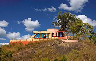
Jhalda is a city and a municipality in Purulia district in the Indian state of West Bengal. It is the headquarters of the Jhalda subdivision.

State Trunk Highway 131 is a 78.9-mile (127.0 km) state highway in the U.S. state of Wisconsin. The highway is located in Wisconsin's Driftless Area, and it passes through Crawford, Vernon, Richland, and Monroe counties. It runs from WIS 60 near Wauzeka north to US Highway 12 and WIS 16 in Tomah. WIS 131 is maintained by the Wisconsin Department of Transportation (WisDOT).

Mukutmanipur is a village in Bankura district of West Bengal, India. It is located at the confluence of the Kangsabati and Kumari rivers close to the Jharkhand border.

Palm Island Airport is an airport in Palm Island, on Great Palm Island, Queensland, Australia.
U.S. Route 93 in the state of Arizona is a United States Numbered Highway that begins in Wickenburg and heads north to the Nevada state line at the Mike O'Callaghan–Pat Tillman Memorial Bridge.

State Route 262 (SR 262) is a state highway in the U.S. state of Washington, serving rural Grant County. The highway travels north from SR 26 between Royal City and Othello through farmland and east through the Columbia National Wildlife Refuge and on top of the O'Sullivan Dam over the Potholes Reservoir before ending at SR 17 northwest of Warden. A roadway to the Potholes Reservoir has appeared on maps since 1922 and a fully paved road on the current route was built by 1981. SR 262 was designated in 1991 primarily to serve Potholes State Park.

State Route 263 is a 9.24-mile (14.87 km) long state highway in the U.S. state of Washington, serving rural Franklin County and the Lower Monumental Dam. The highway begins at the Port of Windust on the Snake River and travels east to the Lower Monumental Dam and north to SR 260 in Kahlotus, paralleling the Columbia Plateau Trail. Devils Canyon carried traffic on the Spokane, Portland and Seattle Railway in the early 20th century before the completion of a road serving the Lower Monumental Dam in 1961. The Devils Canyon Road was paved and signed as SR 263 in 1991 and the railroad became the Columbia Plateau Trail the same year.

State Route 194 (SR 194) is a 21.01-mile (33.81 km) long state highway that serves the Lower Granite Dam in Whitman County, located in the U.S. state of Washington. The highway extends eastward from the Port of Almota on the Snake River to an intersection with U.S. Route 195 (US 195) west of Pullman. SR 194 was established in 1991, although the roadway has appeared on maps as early as 1933 and the Almota area being home to a ferry as early as 1893.

The Sirindhorn Dam is in Sirindhorn District, Ubon Ratchatani, Thailand. It impounds the Lam Dom Noi River, and its reservoir is the province's largest water resource. The dam was commissioned in 1971 to serve as a hydropower facility as well as to supply irrigation water. The dam was named after Princess Royal Sirindhorn. All of the electricity generated by the dam is destined for domestic markets. The dam was constructed and is owned and operated by the Electricity Generating Authority of Thailand and is located in the Mekong River Basin, just upstream from the controversial Pak Mun Dam.

In Asia, Google Street View is available in Bangladesh, Bhutan, Cambodia, Hong Kong, Indonesia, Israel, Japan, Kyrgyzstan, Macau, Malaysia, Mongolia, Philippines, Russia, Singapore, South Korea, Sri Lanka, Taiwan, Thailand and Turkey. It is also available for a few select tourist attractions in the People's Republic of China and Pakistan.

Gavali is a small village located in the Belgaum district, Karnataka state in India, southwest of the city of Belgaum. The village is surrounded by forests, waterways and falls, which are subject to illegal mining, removal of medicinal plants and deforestation.
Kinchant Dam is a locality in the Mackay Region, Queensland, Australia. In the 2016 census, Kinchant Dam had a population of 123 people.
