Bandama Caldera

Last updated
Bandama Caldera, Gran Canaria Bandama Caldera.jpg
Bandama Caldera, Gran Canaria

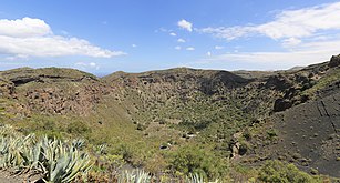
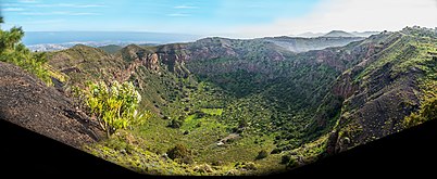
The Bandama Natural Monument is part of the Tafira Protected Landscape on the island of Gran Canaria in the Canary Islands, Spain. It is considered a point of geological interest, because of the Caldera de Bandama. This volcanic crater, which is geologically a maar rather than a caldera, [1] reaches 569 m (1,867 ft) above sea level at the highest point on its rim, Pico de Bandama, and is about 1,000 m (3,300 ft) wide and 200 m (700 ft) deep. The crater was developed during the last heavy eruptions 2000 years ago. It is recorded as the most recent volcanic activity on Gran Canaria. [2]

Contents

The bottom of the caldera contains volcanic ash of different colors, and some botanic species of Canary Islands origin. An endemic bush can be found inside the caldera that doesn't grow anywhere else; Dama de Bandama [3] (parolinia grabiuscula).

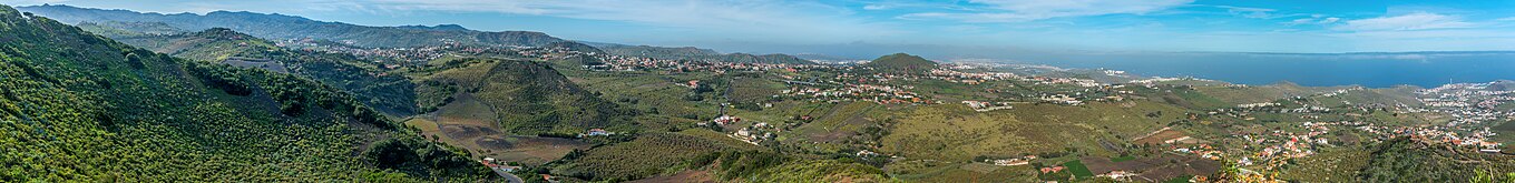
The Caldera de Bandama is located at the meeting point of three municipalities: Las Palmas de Gran Canaria, Santa Brígida and Telde.

Related Research Articles

<span class="mw-page-title-main">Canary Islands</span> Spanish archipelago and region in the Atlantic Ocean

The Canary Islands, also known informally as the Canaries, are a Spanish autonomous community and archipelago in Macaronesia in the Atlantic Ocean. At their closest point to the African mainland, they are 100 kilometres west of Morocco. They are the southernmost of the autonomous communities of Spain. The islands have a population of 2.2 million people and are the most populous special territory of the European Union.

<span class="mw-page-title-main">Las Palmas</span> Municipality in Canary Islands, Spain

Las Palmas, officially Las Palmas de Gran Canaria, is a Spanish city and capital of Gran Canaria, in the Canary Islands, in the Atlantic Ocean.

<span class="mw-page-title-main">Gran Canaria</span> Spanish island of the Canary Islands

Gran Canaria, also Grand Canary Island, is the third-largest and second-most-populous island of the Canary Islands, an archipelago off the Atlantic coast of Northwest Africa which is part of Spain. As of 2019 the island had a population of 851,231 that constitutes approximately 40% of the population of the archipelago. Las Palmas de Gran Canaria, the capital of the island, is the biggest city of the Canary Islands and the ninth of Spain.

<span class="mw-page-title-main">La Palma</span> Most northwestern Canary Island

La Palma, also known as La isla bonita and officially San Miguel de La Palma, is the most northwesterly island of the Canary Islands, Spain. La Palma has an area of 708 square kilometres (273 sq mi) making it the fifth largest of the eight main Canary Islands. The total population at the end of 2020 was 85,840, of which 15,716 lived in the capital, Santa Cruz de La Palma and about 20,467 in Los Llanos de Aridane. Its highest mountain is the Roque de los Muchachos, at 2,423 metres (7,949 ft), being second among the peaks of the Canaries after the Teide massif on Tenerife.

<span class="mw-page-title-main">Lanzarote</span> Island of the Canary Islands, Spain

Lanzarote is a Spanish island, the easternmost of the Canary Islands in the Atlantic Ocean. It is located approximately 125 kilometres off the north coast of Africa and 1,000 kilometres from the Iberian Peninsula. Covering 845.94 square kilometres, Lanzarote is the fourth-largest of the islands in the archipelago. With 152,289 inhabitants at the start of 2019, it is the third most populous Canary Island, after Tenerife and Gran Canaria. Located in the centre-west of the island is Timanfaya National Park, one of its main attractions. The island was declared a biosphere reserve by UNESCO in 1993. The island's capital is Arrecife, which lies on the eastern coastline. It is the smaller main island of the Province of Las Palmas.

<span class="mw-page-title-main">Teide</span> Volcano in Tenerife

Teide, or Mount Teide, is a volcano on Tenerife in the Canary Islands, Spain. Its summit is the highest point in Spain and the highest point above sea level in the islands of the Atlantic. If measured from the ocean floor, its height of 7,500 m (24,600 ft) makes Teide the third-highest volcano in the world, and is described by UNESCO and NASA as Earth's third-tallest volcanic structure. Teide's elevation above sea level makes Tenerife the tenth highest island in the world.

<span class="mw-page-title-main">Cumbre Vieja</span> Volcano in La Palma, Spain

The Cumbre Vieja is an active volcanic ridge on the island of La Palma in the Canary Islands, Spain. The spine of Cumbre Vieja trends in an approximate north–south direction, comprising the southern half of La Palma, with both summit ridge and flanks pockmarked by dozens of craters and cones. The latest eruption began on 19 September 2021 in a forested area of Las Manchas locality known as Cabeza de Vaca. Voluminous lava flows quickly reached populated areas downslope, fanning out across settlements and banana plantations, destroying thousands of buildings and ultimately pouring over steep cliffs into the ocean to enlarge the island at several locations. The volcano went quiet on 13 December 2021, and on 25 December 2021, the local government declared the eruption to be over.

<span class="mw-page-title-main">Caldera de Taburiente National Park</span> National park in the Canary Islands, Spain

Caldera de Taburiente National Park is a national park on the island of La Palma, Canary Islands, Spain. It contains the Caldera de Taburiente, which dominates the northern part of the island, and was designated as a national park in 1954. The telescopes of the Roque de los Muchachos Observatory are situated very close to the summit.

<span class="mw-page-title-main">Lobos Island</span> Spanish Island in the Atlantic

Lobos is a small island of the Canary Islands (Spain) located just 2 kilometres north of the island of Fuerteventura. It belongs to the municipality of La Oliva on the island of Fuerteventura. It has an area of 4.68 square kilometres (1.8 sq mi). It has been a nature reserve since 1982.

<span class="mw-page-title-main">Santa Brígida, Las Palmas</span> Municipality in Canary Islands, Spain

Santa Brígida is a town and a municipality in the northeastern part of the island of Gran Canaria in the Province of Las Palmas of the Canary Islands. Its population is 18,791 (2013), and the area is 23.81 km². It is situated in the mountains, 13 km southwest of Las Palmas.

<span class="mw-page-title-main">Tejeda</span> Municipality in Canary Islands, Spain

Tejeda is a village and a municipality in the mountainous central part of the island of Gran Canaria in the province of Las Palmas in the Canary Islands.

<span class="mw-page-title-main">Roque Nublo</span>

Roque Nublo is a volcanic rock on the island of Gran Canaria, Canary Islands, Spain. It is 67 m (220 ft) tall, and its top is 1,813 m (5,948 ft) above sea level. The Roque Nublo is the third highest point on the island of Gran Canaria, after the Morro de la Agujereada at 1,956 meters, and the Pico de las Nieves at 1,949 meters.

<span class="mw-page-title-main">Puerto Rico de Gran Canaria</span> Holiday resort in Mogán, Gran Canaria

Puerto Rico de Gran Canaria is a holiday resort situated on the south-west coast of the Spanish island of Gran Canaria. Temperatures in the winter remain around 20-25 °C while there is an average of less than three days per month of precipitation.

<span class="mw-page-title-main">Malpaís de Güímar</span>

Malpaís de Güímar or Badlands of Guimar consist of a volcanic cone, subsidiary cones, and several basaltic lava flows in the Güímar municipality on the island of Tenerife, in the Canary Islands, Spain. They total in area about 290 hectares. The lava flows are quite recent, with the typical ʻaʻā type less than 10,000 years old. The large cone is called Montaña Grande and reaches a height of 276 m (906 ft).

Tourism is an essential part of the economy of the Canary Islands, a Spanish archipelago located in the Atlantic Ocean, 100 kilometres west of Morocco. Seven main islands and six islets make up the Canary Islands. They had more than 9 million foreign incoming tourists in 2007. Tourists seeking sunshine and beaches first began to visit the Canaries in large numbers in the 1960s. The Canary Islands are a leading European tourist destination with very attractive natural and cultural resources.

<span class="mw-page-title-main">Guayadeque ravine</span>

The Guayadeque ravine, in Spanish Barranco de Guayadeque, is a ravine-type valley located on the Spanish municipalities of Ingenio and Agüimes, in the province of Las Palmas on Grand Canary island, off the coast of Morocco.

<span class="mw-page-title-main">El Maipés Necropolis</span> Cultural property in Agaete, Spain

The El Maipés necropolis is an ancient burial site near Agaete on the Spanish island of Grand Canary, province of Las Palmas in the Canary Islands of the west coast of Africa.

<span class="mw-page-title-main">Volcanic crater lake</span> Lake formed within a volcanic crater

A volcanic crater lake is a lake in a crater that was formed by explosive activity or a collapse during a volcanic eruption.

<span class="mw-page-title-main">Geology of the Canary Islands</span>

The geology of the Canary Islands is dominated by volcanic rock. The Canary Islands and some seamounts to the north-east form the Canary Volcanic Province whose volcanic history started about 70 million years ago. The Canary Islands region is still volcanically active. The most recent volcanic eruption on land occurred in 2021 and the most recent underwater eruption was in 2011-12.

References

  1. "Gran Canaria: Synonyms & Subfeatures". Global Volcanism Program . Smithsonian Institution . Retrieved 2021-06-26.
  2. "The Geology of the Canary Islands - 1st Edition". www.elsevier.com. Retrieved 2022-12-13.
  3. "Hiking Tips for Caldera de Bandama in Gran Canaria". January 2022. Archived from the original on 2022-02-01.

28°02′0″N15°27′20″W / 28.03333°N 15.45556°W / 28.03333; -15.45556