Captain George Vancouver was a British Royal Navy officer best known for his 1791–1795 expedition, which explored and charted North America's northwestern Pacific Coast regions, including the coasts of what are now the Canadian province of British Columbia as well as the US states of Alaska, Washington, Oregon, and California. The expedition also explored the Hawaiian Islands and the southwest coast of Australia.

Archibald Menzies was a Scottish surgeon, botanist and naturalist. He spent many years at sea, serving with the Royal Navy, private merchants, and the Vancouver Expedition. He was the first recorded European to reach the summit of the Hawaiian volcano Mauna Loa and introduced the Monkey Puzzle tree to England.

The Alexander Archipelago is a 300-mile (480 km) long archipelago in North America lying off the southeastern coast of Alaska. It contains about 1,100 islands, the tops of submerged coastal mountains that rise steeply from the Pacific Ocean. Deep channels and fjords separate the islands and cut them off from the mainland. The islands shelter the northern part of the Inside Passage as it winds its way among them.

John Meares was an English navigator, explorer, and maritime fur trader, best known for his role in the Nootka Crisis, which brought Britain and Spain to the brink of war.
Chatham Strait, or Shee ya xhaak in the Tlingit language, is a narrow passage of the Alexander Archipelago in the southeastern region of the U.S. state of Alaska. It separates Chichagof Island and Baranof Island to its west from Admiralty Island and Kuiu Island on its east.
Robert Gray was an American Merchant Sea Captain who is known for his achievements in connection with two trading voyages to the northern Pacific coast of North America, between 1790 and 1793, which pioneered the American maritime fur trade in that region. In the course of those voyages, Gray explored portions of that coast and in the year 1790 he completed the first American circumnavigation of the world. He was also noted for coming upon and naming the Columbia River, in 1792, while on his second voyage.
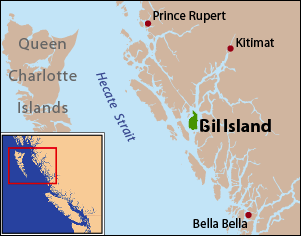
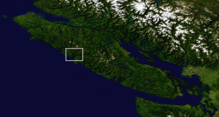
Gil Island is an island on the North Coast of British Columbia, Canada, located on the west side of Whale Channel in the entrance to Douglas Channel, one of the main coastal inlets, on the route of the Inside Passage between Pitt Island and Princess Royal Island. It is 26 km (16 mi) long, with a width ranging from 6 to 13 km, and an area of 231 km2. The only named summit on the mountainous island is Mount Gil, which faces the opening of Douglas Channel.
Jacinto Caamaño Moraleja was the leader of the last great Spanish exploration of Alaska and the coast of what is now British Columbia. He was a Knight of the Military Order of Calatrava.
The Vancouver Expedition (1791–1795) was a four-and-a-half-year voyage of exploration and diplomacy, commanded by Captain George Vancouver of the Royal Navy. The British expedition circumnavigated the globe and made contact with five continents. The expedition at various times included between two and four vessels, and up to 153 men, all but 6 of whom returned home safely.
Towereroo was the first Hawaiian to visit Europe. He returned to the Hawaiian islands on the Vancouver Expedition in 1792. Although during his time the British spelled his name "Toweroo", it would probably be Kualelo with modern Hawaiian language spelling.

During the Age of Exploration, the Spanish Empire undertook several expeditions to the Pacific Northwest of North America. Spanish claims to the region date to the papal bull of 1493, and the Treaty of Tordesillas signed in 1494. In 1513, this claim was reinforced by Spanish explorer Vasco Núñez de Balboa, the first European to sight the Pacific Ocean, when he claimed all lands adjoining this ocean for the Spanish Crown. Spain only started to colonize the claimed territory north of present-day Mexico in the 18th century, when it settled the northern coast of Las Californias.

Milbanke Sound is a sound on the coast of the Canadian province of British Columbia.

Porcher Island is an island in Hecate Strait, British Columbia, Canada, near the mouth of the Skeena River and southwest of the port city of Prince Rupert. The locality of Porcher Island is located near the island's northern tip at Humpback Bay, 54°05′11″N130°23′23″W. Stephens and Prescott Islands are located off its northwestern tip.
The Nootka Crisis, also known as the Spanish Armament, was an international incident and political dispute between the Nuu-chah-nulth Nation, Spain, the Kingdom of Great Britain, and the fledgling United States of America triggered by a series of events revolving around sovereignty claims and rights of navigation and trade. It took place during the summer of 1789 at the Spanish outpost Santa Cruz de Nuca, in Nootka Sound on Vancouver Island in present-day British Columbia, Canada. The commander of the outpost, Jose Esteban Martínez, seized some British commercial ships which had come for the maritime fur trade and to build a permanent post at Nootka Sound. Public outcry in Britain led to the mobilization of the Royal Navy, and the possibility of war. Both sides called upon allies, the Dutch joined the side of Britain; Spain mobilized their navy and her key ally France also mobilized theirs, but the latter soon announced they would not go to war. Without French help, Spain had little hope against the British and the Dutch, resulting in Spain seeking a diplomatic solution and making concessions.
Princess Royal was a British merchant ship that sailed on fur trading ventures in the late 1780s, and was captured at Nootka Sound by Esteban José Martínez of Spain during the Nootka Crisis of 1789. Called Princesa Real while under the Spanish Navy, the vessel was one of the important issues of negotiation during the first Nootka Convention and the difficulties in carrying out the agreements. The vessel also played an important role in both British and Spanish exploration of the Pacific Northwest and the Hawaiian Islands. In 1790, while under Spanish control, Princesa Real carried out the first detailed examination of the Strait of Juan de Fuca by non-indigenous peoples, finding, among other places, the San Juan Islands, Haro Strait, Esquimalt Harbour near present-day Victoria, British Columbia, and Admiralty Inlet.

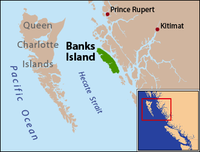
Campania Island is an island on the coast of the Canadian province of British Columbia. It is located south of Prince Rupert, east across Hecate Strait from Haida Gwaii. To its west, across Estevan Sound, is the Estevan Group archipelago. Banks Island lies to the northwest, across Nepean Sound; and Pitt Island to the north, across Otter Channel. To the northeast, across Squally Channel, is Gil Island, and to the east is Princess Royal Island, across Campania Sound. To the south of Campania Island is Caamaño Sound, beyond which is Aristazabal Island.
James Colnett was an officer of the British Royal Navy, an explorer, and a maritime fur trader. He served under James Cook during Cook's second voyage of exploration. Later he led two private trading expeditions that involved collecting sea otter pelts in the Pacific Northwest of North America and selling them in Canton, China, where the British East India Company maintained a trading post. Wintering in the recently discovered Hawaiian Islands was a key component of the new trade system. Colnett is remembered largely for his involvement in the Nootka Crisis of 1789—initially a dispute between British traders and the Spanish Navy over the use of Nootka Sound on Vancouver Island that became an international crisis that led Britain and Spain to the brink of war before being peacefully resolved through diplomacy and the signing of the Nootka Conventions.
Imperial Eagle, originally named Loudoun, was a 400-ton (bm) British merchant ship, launched in 1774 at Liverpool. By 1780 her master was S. Rains, her owner Robertson, and her trade a transport out of London. In 1786 she underwent refitting at Shadwell Dock, Thames, London. She then sailed on maritime fur trading ventures in the late 1780s. She was under the command of Captain Charles William Barkley until confiscated in India.
James Johnstone was a British naval officer and explorer. He is noted for having served as sailing master of the armed tender HMS Chatham and later acting lieutenant during George Vancouver's 1791–1795 expedition to the Pacific Northwest. Johnstone Strait in British Columbia is named after him.
Charles Duncan was a British ship captain engaged in the maritime fur trade and related exploration in the late 1780s. From 1786 to 1788 he was captain of Princess Royal, the tender for Prince of Wales, under James Colnett, both vessels owned by the King George's Sound Company. Colnett and Duncan acquired sea otter furs by trade with the indigenous peoples of the Pacific Northwest Coast, then sold them in Guangzhou (Canton), sailing there via the Hawaiian Islands.