Baram River Last updated February 27, 2025 River in Sarawak, Malaysia
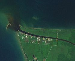
Baram River Mouth of Baram river with black water plume
Native name Sungai Baram (Malay ) Country Malaysia Source Kelabit Highlands • locationConfluence of Kelapang and Dappur Rivers • coordinates 3°25′25.41″N 115°27′11.7252″E / 3.4237250°N 115.453257000°E / 3.4237250; 115.453257000 • elevation710 m (2,330 ft) 2nd source Kelapang River • coordinates 3°27′52.254″N 115°31′35.3928″E / 3.46451500°N 115.526498000°E / 3.46451500; 115.526498000 • elevation1,490 m (4,890 ft) 3rd source Dappur River • coordinates 3°46′11.5284″N 115°33′24.4656″E / 3.769869000°N 115.556796000°E / 3.769869000; 115.556796000 • elevation1,085 m (3,560 ft) Mouth South China Sea • location
at Miri into South China Sea • coordinates
4°35′11.4288″N 113°58′30.5796″E / 4.586508000°N 113.975161000°E / 4.586508000; 113.975161000 • elevation
0 m (0 ft) Length Baram–Kelapang 635 km (395 mi) [ 1] Basin size 22,325 km2 (8,620 sq mi) [ 2] [ 3] Discharge • locationBaram Delta • average58.21 km3 /a (1,845 m3 /s) [ 2] [ 4] Progression South China Sea River system Baram River Tributaries • leftKelapang, Tutoh, Temala, Pelutan, Patah, Akah, Buang, Selaan, Serungo • rightDappur, Arang, Tinjar, Julan, Silat, Moh
The Baram River seen from the ASEAN Bridge The Baram River (Malay : Sungai Baram Sarawak on the island of Borneo . The river originates in the Kelabit Highlands , a watershed demarcated by the Iran Mountains of East Kalimantan , which form a natural border with Sarawak .
Geography The Baram river basin, an area of some 22,325 km 2 (8,620 sq mi) , has been part of Sarawak since it was ceded to the White Rajah of Sarawak by the then sultan of Brunei in 1882, for a perpetual annual payment of 6,000 dollars. [ 5]
The river flows westwards through tropical rainfores (Köppen climate classification Af type) to the South China Sea . [ 6] [ 7] The Baram catchment receives around 3,800 mm of rainfall per year. [ 2] [ 8] The Baram River terminates in a delta , which is subdivided into two units: East Barma Delta of Middle-Late Miocene age and West Baram Delta of Late Miocene-Quaternary age. [ 9] The western unit is composed of mudstones enriched in organic components (total organic carbon content is more than 1.0 wt.%) which constitute substantial oil and gas reserves . [ 10]
The river is crossed not far from its mouth by the Miri-Baram Highway , Federal Route 22 , on the Batang Baram Bridge opened in 2003. Some 100 km upstream lies the town of Marudi . [ 11]
Etymology Batang (meaning "trunk" in Malay) is the name used for the main river in the river system such as "Batang Baram" (Baram river). For upriver areas, such as the areas surrounding the headwaters, the place is named as "Ulu" (which means "upriver"). For example, "Ulu Baram" is the upriver part of the Baram river. [ 12] "Long" meaning "confluence" is used by the Orang Ulu (upriver people). It is used to name the places located at the confluence between the smaller tributaries and the major river, same way as the Malay usage of the name "Kuala" (meaning river delta). The name "Pa'" (meaning "village") is exclusively used in the Kelabit Highlands such as "Pa Umor " village in Bario . [ 12]
History The Baram river flood happened in May 1962. [ 13]
References ↑ "FREQUENCY ANALYSIS OF RIVER FLOW IN SABAH AND SARAWAK" (PDF) . 1 2 3 "Japan International Cooperation Agency" (PDF) . ↑ Ministry of Natural Reserves and Environment, Malaysia: National Water Resources Study, Vol. 29 - Sarawak [ permanent dead link ] MB) page 74 ↑ Prabakaran, Krishnamurthy (2017). "Environmental Geochemistry of the Lower Baram River, Borneo" (PDF) . Archived from the original (PDF) on December 28, 2023. ↑ The Pagan Tribes of Borneo, retrieved 22-05-2007 Archived September 28, 2007, at the Wayback Machine ↑ Reed L. Wadley (2005). Histories of the Borneo Environment . KITLV Press. ISBN 90-6718-254-0 ↑ Louisiana State University ↑ Eric, Tilman. "Kalimantan-Borneo" . ↑ Hutchison, Charles (2005). Geology of North-West Borneo: Sarawak, Brunei and Sabah . Amsterdam: Elsevier. ISBN 978-0-444-51998-6 ↑ Togunwa, Olayinka; Abdullah, Wan (2017-08-10). "Geochemical characterization of Neogene sediments from onshore West Baram Delta Province, Sarawak: paleoenvironment, source input and thermal maturity" . Open Geosciences . 9 (1): 302– 313. doi : 10.1515/geo-2017-0025 . ISSN 2391-5447 . ↑ "处处垃圾 影响环境 美里河污染严重 (Garbage everywhere Miri River environmental pollution)" . Xinhua Daily (Shihua News) (in Chinese). 15 June 2014. Archived from the original on 16 June 2014. Retrieved 14 July 2017 . 1 2 "Sarawak place names" . Rough Guides . Archived from the original on 9 October 2018. Retrieved 9 October 2018 . ↑ "Recorded Flood Events in Sarawak (1946 - 1996)" . Sarawak Drainage and Irrigation Department. Archived from the original on 16 April 2023. Retrieved 16 April 2023 . This page is based on this
Wikipedia article Text is available under the
CC BY-SA 4.0 license; additional terms may apply.
Images, videos and audio are available under their respective licenses.